
for Thursday, 10 April 2014 [8:05 AM PhT]
Issued at: 6:30 PM PhT (10:30 GMT) Thursday 10 April 2014
Tropical Depression PEIPAH (DOMENG) has weakened into an area of low pressure due to unfavorable atmospheric conditions while over the South Philippine Sea during the past 12 hours.
*This is the last and final update on TD Peipah (Domeng).
Information based on data collected by WeatherPhilippines Foundation, Inc. shall not be taken as official data. Weather information broadcasted and distributed by PAGASA remains as official data. WeatherPhilippines shall not be responsible for the private use and reliance of its weather information.
CYCLONE HAZARDS AFFECTING LAND
Below are the regions or places in the Philippines with possible effects caused by the remnants of tropical cyclone.
EASTERN VISAYAS including DINAGAT & SIARGAO ISLANDS: Moderate to Heavy rains of 30 to 50 mm are likely to occur beginning Friday morning until Monday morning. Residents in these areas are advised to be always on alert and closely monitor the weather situation for possible changes in its forecast.
CURRENT CYCLONE INFORMATION
As of 5:00 PM PhT today...0900 GMT.
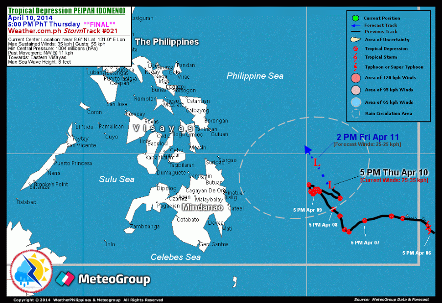
Location: Over the northern part of the South Philippine Sea (near 8.6N 131.0E)
About: 520 km east-northeast of Bislig City, Surigao Del Sur...or 645 km southeast of Guiuan, Eastern Samar
Maximum Sustained Winds (1-min avg): 35 kph near the center...Gustiness: 55 kph
24 hr. Rain Accumulation (near and west of the center): 2 to 400 mm [Slight to Extreme]
Size (in diameter): 500 km (Small)
Past Movement: Northwest @ 11 kph
Forecast Movement: Northwest at 13 kph
Towards: Eastern Samar
1-DAY FORECAST OUTLOOK*
The remnants of Peipah (Domeng) is expected to continue moving northwestward throughout the forecast period. On the forecast track, the remnants of TD Peipah will still be over the northern part of South Philippine Sea on Friday afternoon.
The following is the summary of the 1-day forecast outlook on this system:
FRIDAY AFTERNOON: Dissipating over the South Philippine Sea...about 470 km E of Siargao Island [2PM APR 11: 9.6N 130.4E @ 35kph].
*Please be reminded that the Forecast Outlook changes every 6 hours, and the Day 2 and 3 Forecast Track has an average error of 100 and 250 km respectively...while the wind speed forecast error, averages 35 kph per day. Therefore, a turn to the left or right of its future track and changes in its wind speed must be anticipated from time to time.
Important Note: Please keep in mind that the above hazards summary and forecast outlook changes every 6 to 12 hrs!
ADDITIONAL DISTANCES & TECHNICAL INFO
Time/Date: 5:00 PM PhT Thu Apr 10, 2014
Class/Name: TD Peipah (Domeng)
Minimum Central Pressure: 1004 millibars (hPa)
Location of Center: Near 8.6º N Lat 131.0º E Lon
Distance 1: 490 km ENE of Cateel, Davao Oriental
Distance 2: 520 km ENE of Bislig City
Distance 3: 565 km ESE of Siargao Island
Distance 4: 610 km ESE of Surigao City
Distance 5: 645 km SE of Guiuan, Eastern Samar
T2K/WP StormTrack (for Public): GIF
CURRENT TRACKING MAP:
 _____________________________________________________________________________
__________________________________________________________________________________________________
CURRENT NOAA/MTSAT-2 INFRARED (IR) SATELLITE IMAGE:

__________________________________________________________________________________________________
>> To know the meteorological terminologies and acronyms used on this update visit the ff:
http://typhoon2000.ph/tcterm.htm
http://www.nhc.noaa.gov/aboutgloss.shtml
http://www.nhc.noaa.gov/acronyms.shtml
For the complete details on TD PEIPAH (DOMENG)...go visit our website @:
> http://www.typhoon2000.com
> http://www.maybagyo.com
Copyright © 2014 Typhoon2000.com All Rights Reserved
| Reply via web post | Reply to sender | Reply to group | Start a New Topic | Messages in this topic (1) |

No comments:
Post a Comment