
for Saturday, 01 February 2014 [2:52 PM PhT]
WEATHER.COM.PH TROPICAL CYCLONE UPDATES
TROPICAL DEPRESSION KAJIKI (BASYANG) UPDATE NUMBER 007
Issued at: 12:30 PM PhT (04:30 GMT) Saturday 01 February 2014
Next Update: 6:00 PM PhT (10:00 GMT) Saturday 01 February 2014
KAJIKI (BASYANG) has weakened into a Tropical Depression as it traverses Western Visayas...associated cloudiness are still bringing moderate to heavy downpours across Western Visayas and Palawan which could trigger flashfloods and landslides.
Residents and visitors along MiMaRoPa should closely monitor the development of TD Kajiki (Basyang).
Information based on data collected by WeatherPhilippines Foundation, Inc. shall not be taken as official data. Weather information broadcasted and distributed by PAGASA remains as official data. WeatherPhilippines shall not be responsible for the private use and reliance of its weather information.
CURRENT CYCLONE INFORMATION
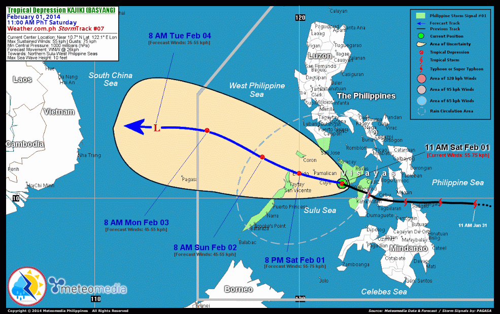
As of 11:00 AM PhT today...0300 GMT...
Location: Along the southern border of Iloilo and Antique (near 10.7N 122.1E)
About: 45 km west of Iloilo City...or 120 km east-southeast of Cuyo Island
Maximum Sustained Winds (1-min avg): 55 kph near the center...Gustiness: 75 kph
24 hr. Rain Accumulation (near its center): 300 mm [Extreme]
Size (in diameter): 500 km (Small)
Past Movement: West-northwest at 26 kph
Forecast Movement: West-northwest at 19 kph
Towards: Northern Sulu-West Philippine Seas
3-DAY FORECAST OUTLOOK*
Kajiki (Basyang) is expected to move west-northwest to northwest within the next 24 to 48 hrs, with a turn to the west through 72 hrs. On the forecast track, the core of TD Kajiki (Basyang) will be crossing Northern Sulu Sea this afternoon through evening...and will traverse the West Philippine Sea late tonight through Monday morning before it exits the Philippine Area of Responsibility. Kajiki will then be over the South China Sea by Tuesday noon.
Kajiki (Basyang) is expected to weaken further within the next 24 hours as it moves over an area of unfavorable environment. Advance Intensity Forecast (AIF) shows its 1-minute maximum sustained winds decreasing to 45 kph on Sunday morning.
The following is the summary of the 3-day forecast outlook on this system:
SUNDAY MORNING: Weakens further as it moves over the West Philippine Sea...about 175 km WNW of El Nido, Palawan [8AM FEB 02: 12.0N 118.2E @ 45kph].
MONDAY MORNING: Maintains its strength while moving farther into the West Philippine Sea...about 285 km NE of Pagasa Island, Spratlys [8AM FEB 03: 13.3N 115.5E @ 45kph].
TUESDAY MORNING: Dissipates into an area of low pressure as it moves over the South China Sea...about 290 km NW of Pagasa Island, Spratlys [8AM FEB 04: 13.4N 113.0E @ 35kph].
*Please be reminded that the Forecast Outlook changes every 6 hours, and the Day 2 and 3 Forecast Track has an average error of 100 and 250 km respectively...while the wind speed forecast error, averages 35 kph per day. Therefore, a turn to the left or right of its future track and changes in its wind speed must be anticipated from time to time.
CYCLONE HAZARDS AFFECTING LAND
Below are the regions or places with possible or ongoing effects caused by the current tropical cyclone.
NORTHERN PALAWAN: Heavy rains of 50 to 100 mm will be experienced until Sunday morning. Residents living along the hazard-prone areas are advised to seek shelter and take precautionary measures against flashfloods and landslides.
WESTERN VISAYAS / ROMBLON / CALAMIAN AND CUYO ISLAND GROUP / PORTIONS OF CENTRAL PALAWAN: Moderate to heavy rains of 30-50 mm will be experienced along these areas today...extending through Sunday morning across portions of Central Palawan and the Calamian Group of Islands.. Residents living along hazard-prone areas are advised to seek shelter and take precautionary measures against flashfloods and landslides.
Important Note: Please keep in mind that the above forecast outlook and hazards summary changes every 6 to 12 hrs!
ADDITIONAL DISTANCES & TECHNICAL INFO
Time/Date: 11:00 AM PhT Sat Feb 01, 2014
Class/Name: TD Kajiki (Basyang)
Minimum Central Pressure: 1000 millibars (hPa)
Location of Center: Near 10.7º N Lat 122.1º E Lon
Distance 1: 45 km W of Iloilo City
Distance 2: 120 km ESE of Cuyo Island
Distance 3: 125 km SW of Roxas City
Distance 4: 270 km ESE of El Nido Island
Distance 5: 390 km ENE of Puerto Princesa City
CPA [ETA] to Northern Palawan: Tonight [between 8-10 PM PhT]
Issued by: Leonilo C. Millanes for Weather.com.ph
CURRENT TRACKING MAP:
 _____________________________________________________________________________
__________________________________________________________________________________________________
CURRENT NOAA/MTSAT-2 INFRARED (IR) SATELLITE IMAGE:

__________________________________________________________________________________________________
>> To know the meteorological terminologies and acronyms used on this update visit the ff:
http://typhoon2000.ph/tcterm.htm
http://www.nhc.noaa.gov/aboutgloss.shtml
http://www.nhc.noaa.gov/acronyms.shtml
__________________________________________________________________________________________
For the complete details on TD KAJIKI (BASYANG)...go visit our website @:
> http://www.typhoon2000.com
> http://www.maybagyo.com
<<<Typhoon2000.com Mobile >>>
Get the latest SMS Storm Alerts!
For more details: Text T2K TYPHOON to
2800 (Globe/TM) | Offline (Smart/TNT) | 2288 (Sun)
*Only P2.50 (Smart/Globe) / P2.00 (Sun) per msg received.
Click here on how to use this service (in PDF file)
Powered by: Synermaxx Corporation
Copyright © 2014 Typhoon2000.com All Rights Reserved
| Reply via web post | Reply to sender | Reply to group | Start a New Topic | Messages in this topic (1) |

No comments:
Post a Comment