
for Sunday, 19 January 2014 [7:43 PM PhT]
WEATHER.COM.PH TROPICAL CYCLONE UPDATES
TROPICAL DEPRESSION LINGLING (AGATON) UPDATE NUMBER 007
Issued at: 6:00 PM PhT (10:00 GMT) Sunday 19 January 2014
Next Update: 12:00 AM PhT (16:00 GMT) Monday 20 January 2014
Tropical Depression (TD) LINGLING [AGATON] has remained almost stationary during the past 6 hours while over the South Philippine Sea...east of Davao Oriental. Its thick rainbands continues to spread across Caraga, Davao and Northern Mindanao Regions.
Lingling (Agaton) will continue to enhance the cool surge of the Northeast Monsoon (Hanging Amihan) - bringing mostly cloudy conditions w/ passing drizzles, slight to sometimes moderate rains and gusty winds (not exceeding 70 kph) across Eastern Luzon including Bicol Region and some parts of the Visayas and Northern Mindanao through Monday.
Residents and visitors along Eastern, Central and Southern Mindanao should closely monitor the development of Lingling (Agaton).
Information based on data collected by WeatherPhilippines Foundation, Inc. shall not be taken as official data. Weather information broadcasted and distributed by PAGASA remains as official data. WeatherPhilippines shall not be responsible for the private use and reliance of its weather information.
CURRENT CYCLONE INFORMATION
As of 5:00 PM PhT today...0900 GMT...
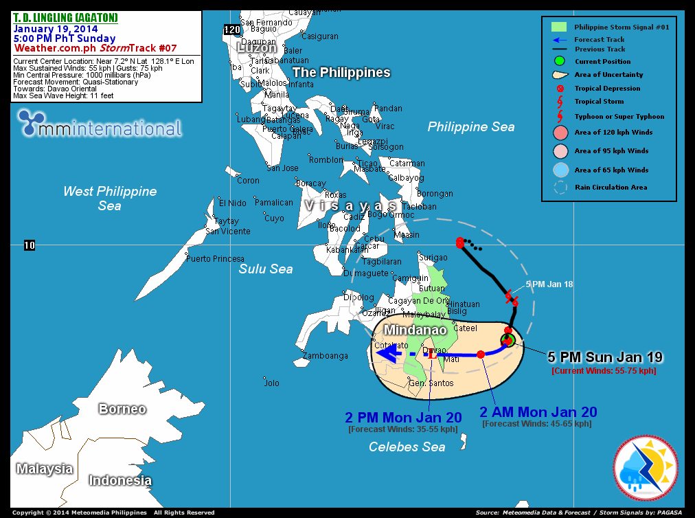
Location: Over the South Philippine Sea (near 7.2N 128.1E)
About: 185 km east-southeast of Cateel, Davao Oriental...or 215 km east-northeast of Mati City
Maximum Sustained Winds (1-min avg): 55 kph near the center...Gustiness: 75 kph
24 hr. Rain Accumulation (along its rainbands): Extreme [400 mm]
Size (in diameter): Small (445 km)
Past Movement: Quasi-Stationary
Forecast Movement: West-southwest at 09 kph
Towards: The Southern Tip of Davao Oriental
1-DAY FORECAST OUTLOOK*
TD Lingling (Agaton) is expected to move west-southwest slowly within the next 24 hours. On the forecast track, the weakening core of TD Lingling (Agaton) will be crossing the southern tip of Davao Oriental on Monday morning...and will be traversing Davao Gulf Monday afternoon.
TD Lingling (Agaton) is expected to continue losing strength within the next 12 hours and will weaken further into an area of low pressure through 24 hours as it makes landfall along the mountainous terrain of Davao Oriental. Advance Intensity Forecast (AIF) shows its 1-minute maximum sustained winds decreasing to 35 km/hr on Monday afternoon.
The following is the summary of the 1-day forecast outlook on this system:
MONDAY AFTERNOON: Weakens into an area of low pressure...over Davao Gulf [2PM JAN 20: 6.8N 125.9E @ 35kph].
*Please be reminded that the Forecast Outlook changes every 6 hours, and the Day 2 and 3 Forecast Track has an average error of 100 and 250 km respectively...while the wind speed forecast error, averages 35 kph per day. Therefore, a turn to the left or right of its future track and changes in its wind speed must be anticipated from time to time.
CYCLONE HAZARDS AFFECTING LAND
Below are the regions or places with possible or ongoing effects caused by the current tropical cyclone:
CARAGA / NORTHERN MINDANAO / DAVAO REGION - Heavy rains of 50 to 100 mm will be experienced along these areas...becoming extreme rains of more than 100 mm along the provinces of Surigao Provinces, Davao Oriental, Agusan Provinces, & eastern portions of Compostela Valley through Monday morning. Residents living along the hazard-prone areas are advised to take precautionary measures against flashfloods and landslides.
NORTHERN SOCCSKSARGEN / NORTHERN ARMM / ZAMBOANGA DEL NORTE / BOHOL / SOUTHERN PORTION OF NEGROS ORIENTAL / SOUTHERN LEYTE / SOUTHERN CEBU - Moderate to heavy rains of 30-50 mm will be experienced along these areas through Monday morning. Residents living along hazard-prone areas are advised to take precautionary measures against flashfloods and landslides.
Important Note: Please keep in mind that the above forecast outlook and hazards summary changes every 6 to 12 hrs!
CURRENT TECHNICAL INFORMATION
Time/Date: 5:00 PM PhT Sun Jan 19, 2014
Class/Name: TD Lingling (Agaton)
Location of Center: Near 7.2º N Lat 128.1º E Lon
Distance 1: 185 km ESE of Cateel, Davao Oriental
Distance 2: 215 km ENE of Mati City
Distance 3: 225 km SE of Bislig City
Distance 4: 275 km E of Metro Davao
MaxWinds (1-min avg): 55 kph near the center
Peak Wind Gusts: 75 kph
Past Movement: Quasi-Stationary
Forecast Movement: WSW @ 09 kph
Towards: Sea south of Davao Oriental
Minimum Central Pressure: 1000 millibars (hPa)
Issued by: David Michael V. Padua for Weather.com.ph
CURRENT TRACKING MAP:
 _____________________________________________________________________________
__________________________________________________________________________________________________
CURRENT NOAA/MTSAT-2 INFRARED (IR) SATELLITE IMAGE:

__________________________________________________________________________________________________
>> To know the meteorological terminologies and acronyms used on this update visit the ff:
http://typhoon2000.ph/tcterm.htm
http://www.nhc.noaa.gov/aboutgloss.shtml
http://www.nhc.noaa.gov/acronyms.shtml
__________________________________________________________________________________________
For the complete details on TD LINGLING (AGATON)...go visit our website @:
> http://www.typhoon2000.com
> http://www.maybagyo.com
<<<Typhoon2000.com Mobile >>>
Get the latest SMS Storm Alerts!
For more details: Text T2K TYPHOON to
2800 (Globe/TM) | Offline (Smart/TNT) | 2288 (Sun)
*Only P2.50 (Smart/Globe) / P2.00 (Sun) per msg received.
Click here on how to use this service (in PDF file)
Powered by: Synermaxx Corporation
Copyright © 2014 Typhoon2000.com All Rights Reserved
| Reply via web post | Reply to sender | Reply to group | Start a New Topic | Messages in this topic (1) |

No comments:
Post a Comment