
for Sunday, 03 November 2013 [7:11 AM PhT]
WEATHER.COM.PH TROPICAL CYCLONE UPDATES
TYPHOON KROSA (VINTA) UPDATE NUMBER 017
Issued at: 6:00 AM PhT (22:00 GMT) Sunday 03 November 2013
Next Update: 6:00 PM PhT (10:00 GMT) Sunday 03 November 2013
Typhoon KROSA (VINTA) has weakened gradually while barely moving over the South China Sea...likely to move southwestward towards Vietnam.
Residents and visitors along Southern China, Hainan Island and Central Vietnam should closely monitor the development of Krosa (Vinta).
Do not use this for life or death decisions. This update is intended for additional information purposes only. Kindly refer to your national weather agency for official warnings, advisories or bulletins.
CURRENT STORM ANALYSIS
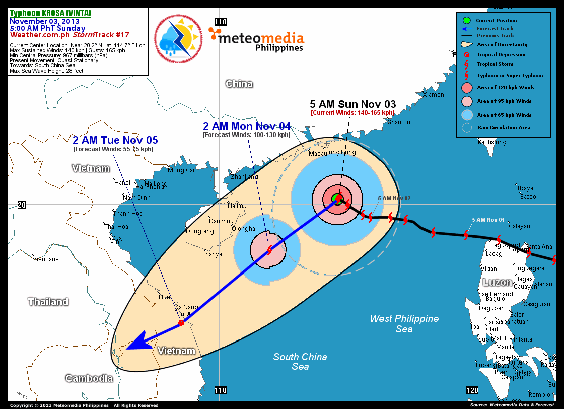
As of 5:00 am today, the eye of TY Krosa (Vinta) was located over the northwestern part of the South China Sea...about 240 km south-southeast of Hong Kong, China or 460 km east of Haikou, Hainan Island...currently quasi-stationary over the South China Sea.
Maximum Sustained Winds (1-min. avg) have decreased to 140 km/hr near the center with higher gusts. Typhoon Force Winds (118 km/hr or more) extend outward up to 65 kilometers from the center...and Tropical Storm Force Winds (63-117 km/hr) extend outward up to 205 kilometers. TY Krosa (Vinta) is a small-sized tropical cyclone with a diameter of 500 kilometers across.
2-DAY FORECAST OUTLOOK*
TY Krosa (Vinta) is expected to drift slowly west-southwest or southwestward in the next 12 hours before accelerating through 48 hours. On the forecast track, the core of TY Krosa (Vinta) will remain over the open waters of the South China Sea, well to the east of Hainan Island today through Monday...and will make landfall over Central Vietnam on Tuesday.
TY Krosa (Vinta) will continue to lose strength throughout the forecast period due to entrainment of dry continental air from China. This system will be downgraded into a Tropical Storm (TS) within the next 24 hours as it moves across the western part of the South China Sea. Advance Intensity Forecast (AIF) shows its 1-minute maximum sustained winds decreasing further to 55 km/hr on Tuesday early morning, as it makes landfall over Central Vietnam.
The following is the summary of the 2-day forecast outlook on this system:
 MONDAY EARLY MORNING: Accelerating west-southwest to southwestward across the western part of the South China Sea...weakens to TS...about 195 km southeast of Qionghai, Hainan Island [2AM NOV 04: 18.2N 112.0E @ 100kph].
TUESDAY EARLY MORNING: Makes landfall over Central Vietnam as a Tropical Depression (TD)...about 60 km south-southeast of Hoi An, Vietnam [2AM NOV 05: 15.3N 108.5E @ 55kph].
*Please be reminded that the Forecast Outlook changes every 6 hours, and the Day 2 and 3 Forecast Track has an average error of 100 and 250 km respectively...while the wind speed forecast error, averages 35 kph per day. Therefore, a turn to the left or right of its future track and changes in its wind speed must be anticipated from time to time.
EFFECTS & HAZARDS SUMMARY
Below is the summary of the storm's parts and its hazards affecting specific areas. You can also view this image link for you to understand the parts.
CLOUD-FILLED EYE - over the northwestern portion of the South China Sea. Possible calm and lull conditions (with <20 kph winds) will be expected inside the eye (click here to know more about the EYE). EYEWALL - where Typhoon Conditions with Typhoon Force Winds (>118 kph) will be expected within this wall. Affected Areas: Northwestern part of the South China Sea (click here to know more about the Eyewall). INNER RAINBANDS - where Tropical Storm Conditions with Tropical Storm Force Winds (63-100 kph) will be expected. Affected Areas: Northern and NW part of the South China Sea. OUTER RAINBANDS - where Tropical Depression Conditions with light, moderate to strong winds (30-62 kph) will be expected. Affected Areas: Coastal areas of Guangdong Province, China and Northwestern part of the South China Sea (click here to know more about Rainbands). 24HR TOTAL RAINFALL ACCUMULATION - from 5 up to 200 mm (slight to heavy rainfall) can be expected along areas affected by the outer & inner rainbands (see above)...with isolated amounts of 201 to 400 mm (heavy to extreme) along areas near the center of Krosa (Vinta).
Important Note: Please keep in mind that the above forecast outlook, effects and hazards summary changes every 6 to 12 hrs!
CURRENT TECHNICAL INFORMATION
Time/Date: 5:00 AM PhT Sun Nov 03, 2013
Class/Name: TY Krosa (Vinta)
Location of Eye: Near 20.2º N Lat 114.7º E Lon
Distance 1: 240 km SSE of Hong Kong, China
Distance 2: 250 km SSE of Macau, China
Distance 3: 460 km E of Haikou, Hainan Island
MaxWinds (1-min avg): 140 kph near the center
Peak Wind Gusts: 165 kph
Saffir-Simpson Hurricane Scale: Category 3
Present Movement: Quasi-Stationary
Towards: South China Sea
Minimum Central Pressure: 967 millibars (hPa)
T2K/WP StormTracks (for Public): GIF | Google Map (Flash)
CURRENT TRACKING MAP:
 _____________________________________________________________________________
__________________________________________________________________________________________________
CURRENT NOAA/MTSAT-2 INFRARED (IR) SATELLITE IMAGE:

__________________________________________________________________________________________________
>> To know the meteorological terminologies and acronyms used on this update visit the ff:
http://typhoon2000.ph/tcterm.htm
http://www.nhc.noaa.gov/aboutgloss.shtml
http://www.nhc.noaa.gov/acronyms.shtml
__________________________________________________________________________________________
For the complete details on TY KROSA (VINTA)...go visit our website @:
> http://www.typhoon2000.com
> http://www.maybagyo.com
<<<Typhoon2000.com Mobile >>>
Get the latest SMS Storm Alerts!
For more details: Text T2K TYPHOON to
2800 (Globe/TM) | Offline (Smart/TNT) | 2288 (Sun)
*Only P2.50 (Smart/Globe) / P2.00 (Sun) per msg received.
Click here on how to use this service (in PDF file)
Powered by: Synermaxx Corporation
Copyright © 2013 Typhoon2000.com All Rights Reserved
| Reply via web post | Reply to sender | Reply to group | Start a New Topic | Messages in this topic (1) |

No comments:
Post a Comment