
for Tuesday, 05 November 2013 [7:47 AM PhT]
WEATHER.COM.PH TROPICAL CYCLONE UPDATES
TROPICAL STORM HAIYAN UPDATE NUMBER 002
Issued at: 6:00 AM PhT (22:00 GMT) Tuesday 05 November 2013
Next Update: 6:00 PM PhT (10:00 GMT) Tuesday 05 November 2013
Tropical Storm HAIYAN rapidly intensifying as it moves quickly across the central part of the Caroline Islands...will become a Typhoon today. Dynamic Forecast Models indicate Haiyan to make landfall over Eastern Visayas or Southern Bicol (Samar-Leyte-Masbate-Sorsogon Area) on Friday, November 8. Residents living along the eastern seaboards of the Philippines from Northern Quezon...Bicol Region...down to Northeastern Mindanao should pay attention on the approach of this potentially destructive typhoon. Plans for emergency situation and/or disaster planning must be implemented now as the storm is only 3 days away from hitting land.
Residents and visitors along Northeastern Mindanao, Visayas, Bicol Region and Eastern Luzon should closely monitor the development of Haiyan.
Do not use this for life or death decisions. This update is intended for additional information purposes only. Kindly refer to your national weather agency for official warnings, advisories or bulletins.
CURRENT STORM ANALYSIS
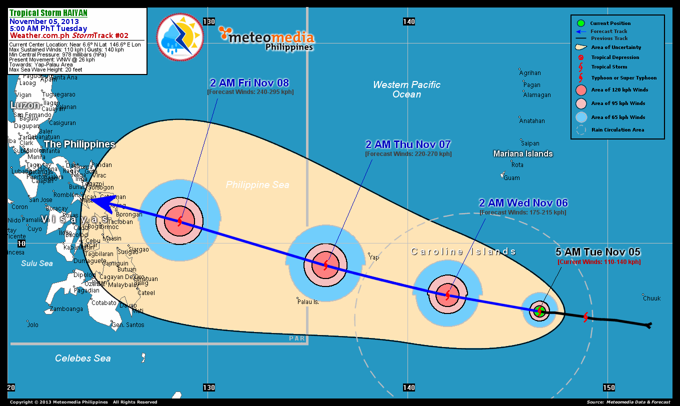
As of 5:00 am today, the center of TS Haiyan was located over the central part of the Caroline Islands...about 780 km south-southeast of Hagatna, Guam or 2,390 km east-southeast of Samar, Philippines...currently moving west-northwest with a forward speed of 26 km/hr towards Yap-Palau Area.
Maximum Sustained Winds (1-min. avg) have increased to 110 km/hr near the center with higher gusts. Tropical Storm Force Winds (63-117 km/hr) extend outward up to 100 kilometers from the center. TS Haiyan is a small-sized tropical cyclone with a diameter of 445 kilometers across.
2-DAY FORECAST OUTLOOK*
TS Haiyan is expected to move in a generally straight, west-northwest track throughout the forecast period. On the forecast track, the core of TS Haiyan will passing in between the islands of Yap and Palau on Thursday early morning...and will enter the Philippine Area of Responsibility (PAR).
TS Haiyan will continue to rapidly intensify within the next 24 to 48 hours as the system moves over the warmer sea surface temperatures of the Pacific...and could become a Category 4 Typhoon on Wednesday evening. Advance Intensity Forecast (AIF) shows its 1-minute maximum sustained winds increasing to 220 km/hr by Thursday early morning.
The following is the summary of the 2-day forecast outlook and an extended 3-day forecast on this system:
 WEDNESDAY EARLY MORNING: Approaching Category 3 strength as it heads for Western Micronesia...about 490 km southeast of Colonia, Yap [2AM NOV 06: 7.4N 142.0E @ 175kph].
THURSDAY EARLY MORNING: Strengthens to a Category 4 Typhoon as it passes in between the islands of Yap and Palau...about 235 km northeast of Koror, Palau [2AM NOV 07: 8.9N 135.9E @ 220kph].
FRIDAY EARLY MORNING: Becomes a Super Typhoon as it moves faster to the west-northwest...approaching the eastern coast of Samar Island...about 355 km east-southeast of Borongan City, Eastern Samar, PH [2AM NOV 08: 11.1N 128.6E @ 240kph].
*Please be reminded that the Forecast Outlook changes every 6 hours, and the Day 2 and 3 Forecast Track has an average error of 100 and 250 km respectively...while the wind speed forecast error, averages 35 kph per day. Therefore, a turn to the left or right of its future track and changes in its wind speed must be anticipated from time to time.
EFFECTS & HAZARDS SUMMARY
Below is the summary of the storm's parts and its hazards affecting specific areas. You can also view this image link for you to understand the parts.
CENTRAL DENSE OVERCAST (CDO) - where Near-Typhoon Conditions w/ Near-Typhoon Force Winds (101-120 kph) will be expected along the CDO (click here to know more about CDO). Possible "Eye" may also be forming underneath the cirrus canopy. Affected Areas:Central part of the Caroline Islands. INNER RAINBANDS - where Tropical Storm Conditions with Tropical Storm Force Winds (63-100 kph) will be expected. Affected Areas: Central part of the Caroline Islands. OUTER RAINBANDS - where Tropical Depression Conditions with light, moderate to strong winds (30-62 kph) will be expected. Affected Areas: Central part of Caroline Islands, Yap and Chuuk State (Federated States of Micronesia) (click here to know more about Rainbands). 24HR TOTAL RAINFALL ACCUMULATION - from 5 up to 100 mm (slight to heavy rainfall) can be expected along areas affected by the outer & inner rainbands (see above)...with isolated amounts of 101 to 200 mm (heavy) along areas near the center of Haiyan.
Important Note: Please keep in mind that the above forecast outlook, effects and hazards summary changes every 6 to 12 hrs!
CURRENT TECHNICAL INFORMATION
Time/Date: 5:00 AM PhT Tue Nov 05, 2013
Class/Name: TS Haiyan
Location of Center: Near 6.6º N Lat 146.6º E Lon
Distance 1: 780 km SSE of Guam, CNMI
Distance 2: 990 km ESE of Yap State
Distance 3: 1280 km E of P.A.R.
Distance 4: 1340 km ESE of the Republic of Palau
Distance 5: 2390 km ESE of Samar, PH
MaxWinds (1-min avg): 110 kph near the center
Peak Wind Gusts: 140 kph
Present Movement: WNW @ 26 kph
Towards: Yap-Palau Area
Minimum Central Pressure: 978 millibars (hPa)
T2K/WP StormTracks (for Public): GIF
CURRENT TRACKING MAP:
 _____________________________________________________________________________
__________________________________________________________________________________________________
CURRENT NOAA/MTSAT-2 INFRARED (IR) SATELLITE IMAGE:

__________________________________________________________________________________________________
>> To know the meteorological terminologies and acronyms used on this update visit the ff:
http://typhoon2000.ph/tcterm.htm
http://www.nhc.noaa.gov/aboutgloss.shtml
http://www.nhc.noaa.gov/acronyms.shtml
__________________________________________________________________________________________
For the complete details on TS HAIYAN...go visit our website @:
> http://www.typhoon2000.com
> http://www.maybagyo.com
<<<Typhoon2000.com Mobile >>>
Get the latest SMS Storm Alerts!
For more details: Text T2K TYPHOON to
2800 (Globe/TM) | Offline (Smart/TNT) | 2288 (Sun)
*Only P2.50 (Smart/Globe) / P2.00 (Sun) per msg received.
Click here on how to use this service (in PDF file)
Powered by: Synermaxx Corporation
Copyright © 2013 Typhoon2000.com All Rights Reserved
| Reply via web post | Reply to sender | Reply to group | Start a New Topic | Messages in this topic (1) |

No comments:
Post a Comment