
for Monday, 04 November 2013 [10:24 PM PhT]
WEATHER.COM.PH TROPICAL CYCLONE UPDATES
TROPICAL STORM HAIYAN UPDATE NUMBER 001
Issued at: 8:00 PM PhT (12:00 GMT) Monday 04 November 2013
Next Update: 6:00 AM PhT (22:00 GMT) Tuesday 05 November 2013
The broad and strong disturbance (LPA) over the easternmost Caroline Islands which has intensified yesterday into a Tropical Depression (TD)...is now a strong Tropical Storm, internationally named HAIYAN (a Chinese word for Petrel, a kind of seabird). Dynamic Forecast Models indicate a dangerous Typhoon which could become a Super Typhoon...moving towards the central part of the Philippines...with a possible landfall over Eastern Visayas (Samar-Leyte-Masbate Area) on Friday, November 8. Residents living along the eastern seaboards of the Philippines from Northern Quezon...Bicol Region...down to Northeastern Mindanao should pay attention on the approach of this potentially destructive cyclone. Plans for emergency situation and/or disaster planning is a must as the storm is only 4 days away from hitting land.
Residents and visitors along Northeastern Mindanao, Visayas, Bicol Region and Eastern Luzon should closely monitor the development of Haiyan.
Do not use this for life or death decisions. This update is intended for additional information purposes only. Kindly refer to your national weather agency for official warnings, advisories or bulletins.
CURRENT STORM ANALYSIS
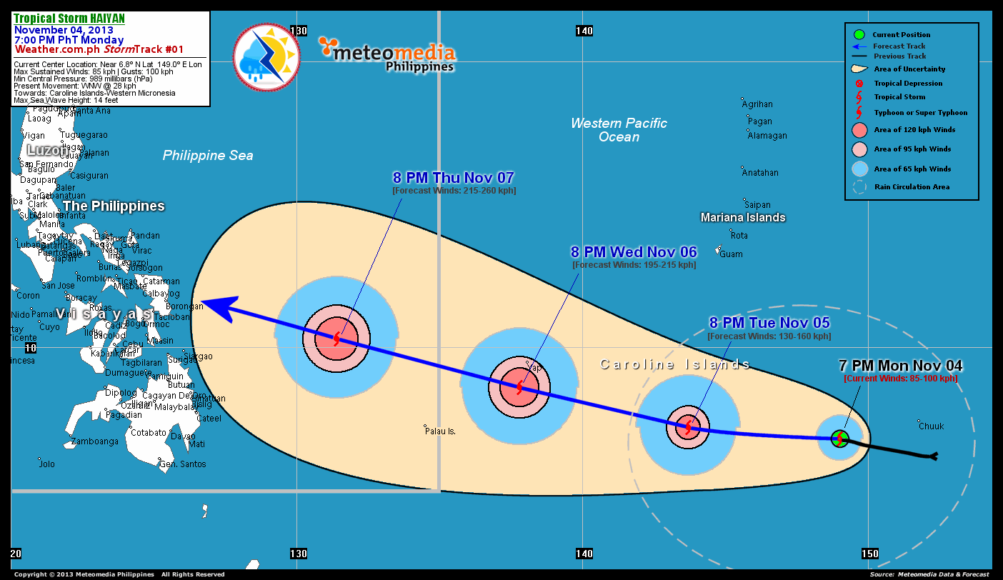
As of 7:00 pm today, the center of TS Haiyan was located over the central part of the Caroline Islands, just west of Chuuk State...about 865 km south-southeast of Hagatna, Guam or 2,645 km east-southeast of Samar, Philippines...currently moving west-northwest with a forward speed of 28 km/hr towards Yap State in Western Micronesia.
Maximum Sustained Winds (1-min. avg) are at 85 km/hr near the center with higher gusts. Tropical Storm Force Winds (63-117 km/hr) extend outward up to 85 kilometers from the center. TS Haiyan is a small-sized tropical cyclone with a diameter of 445 kilometers across.
2-DAY FORECAST OUTLOOK*
TS Haiyan is expected to continue moving slightly westerly during the the next 24 hours...with a west-northwest turn through 48 hours. On the forecast track, the core of TS Haiyan will passing just to the south of Yap State on Wednesday evening.
TS Haiyan will gradually intensify within the next 24 to 48 hours as the system moves over the warm open waters of the Western Pacific Ocean...and could become a well-developed Typhoon on Tuesday. Advance Intensity Forecast (AIF) shows its 1-minute maximum sustained winds increasing to almost 200 km/hr on Wednesday afternoon.
The following is the summary of the 2-day forecast outlook and an extended 3-day forecast on this system:
 TUESDAY EVENING: Strengthens into a Typhoon (Category 1) as it heads for Yap State...about 665 km east-southeast of Colonia, Yap [8PM NOV 05: 7.2N 143.7E @ 130kph].
WEDNESDAY EVENING: Becomes a Category 3 Typhoon as it passes to the south of Yap State...about 105 km south-southwest of Colonia, Yap [2PM NOV 06: 8.6N 137.8E @ 195kph].
THURSDAY EVENING: Moving across the Philippine Sea as a Category 4 Typhoon as it dangerously approaches Eastern Visayas...about 670 km east-southeast of Borongan City, Eastern Samar, PH [8PM NOV 07: 10.3N 131.4E @ 215kph].
*Please be reminded that the Forecast Outlook changes every 6 hours, and the Day 2 and 3 Forecast Track has an average error of 100 and 250 km respectively...while the wind speed forecast error, averages 35 kph per day. Therefore, a turn to the left or right of its future track and changes in its wind speed must be anticipated from time to time.
EFFECTS & HAZARDS SUMMARY
Below is the summary of the storm's parts and its hazards affecting specific areas. You can also view this image link for you to understand the parts.
INNER RAINBANDS - where Tropical Storm Conditions with Tropical Storm Force Winds (63-100 kph) will be expected. Affected Areas: Central part of the Caroline Islands. OUTER RAINBANDS - where Tropical Depression Conditions with light, moderate to strong winds (30-62 kph) will be expected. Affected Areas: Central part of Caroline Islands and Chuuk State (Federated States of Micronesia) (click here to know more about Rainbands). 24HR TOTAL RAINFALL ACCUMULATION - from 5 up to 100 mm (slight to heavy rainfall) can be expected along areas affected by the outer & inner rainbands (see above)...with isolated amounts of 101 to 250 mm (heavy) along areas near the center of Haiyan.
Important Note: Please keep in mind that the above forecast outlook, effects and hazards summary changes every 6 to 12 hrs!
CURRENT TECHNICAL INFORMATION
Time/Date: 7:00 PM PhT Mon Nov 04, 2013
Class/Name: TS Haiyan
Location of Center: Near 6.8º N Lat 149.0º E Lon
Distance 1: 865 km SSE of Guam, CNMI
Distance 2: 1235 km ESE of Yap State
Distance 3: 1545 km E of P.A.R.
Distance 4: 1600 km ESE of Republic of Palau
Distance 5: 2645 km ESE of Samar Island, PH
MaxWinds (1-min avg): 85 kph near the center
Peak Wind Gusts: 100 kph
Present Movement: WNW @ 28 kph
Towards: Caroline Islands-Western Micronesia Area
Minimum Central Pressure: 989 millibars (hPa)
T2K/WP StormTracks (for Public): GIF
CURRENT TRACKING MAP:
 _____________________________________________________________________________
__________________________________________________________________________________________________
CURRENT NOAA/MTSAT-2 INFRARED (IR) SATELLITE IMAGE:

__________________________________________________________________________________________________
>> To know the meteorological terminologies and acronyms used on this update visit the ff:
http://typhoon2000.ph/tcterm.htm
http://www.nhc.noaa.gov/aboutgloss.shtml
http://www.nhc.noaa.gov/acronyms.shtml
__________________________________________________________________________________________
For the complete details on TS HAIYAN...go visit our website @:
> http://www.typhoon2000.com
> http://www.maybagyo.com
<<<Typhoon2000.com Mobile >>>
Get the latest SMS Storm Alerts!
For more details: Text T2K TYPHOON to
2800 (Globe/TM) | Offline (Smart/TNT) | 2288 (Sun)
*Only P2.50 (Smart/Globe) / P2.00 (Sun) per msg received.
Click here on how to use this service (in PDF file)
Powered by: Synermaxx Corporation
Copyright © 2013 Typhoon2000.com All Rights Reserved
| Reply via web post | Reply to sender | Reply to group | Start a New Topic | Messages in this topic (1) |

No comments:
Post a Comment