
for Monday, 11 November 2013 [11:45 AM PhT]
WEATHER.COM.PH TROPICAL CYCLONE UPDATES
TROPICAL DEPRESSION (ZORAIDA) UPDATE NUMBER 002
Issued at: 12:00 PM PhT (04:00 GMT) Monday 11 November 2013
Next Update: 6:00 PM PhT (10:00 GMT) Monday 11 November 2013
Tropical Depression (TD) [ZORAIDA] has maintained its strength as it continues to move closer to Mindanao...poses threat to the provinces of Northern and Eastern Mindanao and the Visayas.
Residents and visitors along Mindanao and Visayas should closely monitor the development of Zoraida .
Do not use this for life or death decisions. This update is intended for additional information purposes only. Kindly refer to your national weather agency for official warnings, advisories or bulletins.
CURRENT STORM ANALYSIS
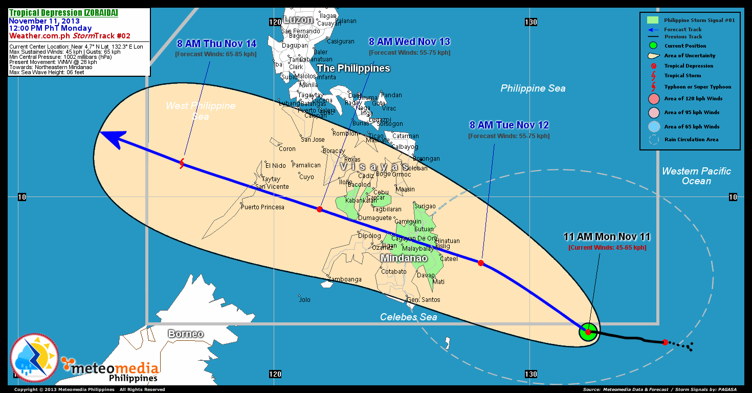
As of 11:00 am today, the center of TD Zoraida was located over south of the South Philippine Sea...about 725 km southeast of Cateel, Davao Oriental or 785 km east-southeast of Metro Davao...currently moving west-northwest with a forward speed of 28 km/hr towards Northeastern Mindanao.
Maximum Sustained Winds (1-min. avg) are at 45 km/hr near the center with higher gusts.
2-DAY FORECAST OUTLOOK*
TD Zoraida is expected to accelerate northwestward during the next 24 hours...turning west-northwestward through 48 hours. On the forecast track, the core of TD Zoraida will make landfall along the border of Surigao Del Sur and Davao Oriental...passing across Agusan Del Sur, Bukidnon and Misamis Oriental on Tuesday afternoon through evening...and will traverse the Mindanao Sea Wednesday early morning on its way to the Sulu Sea.
TD Zoraida will slightly intensify within the next 24 hours. Advance Intensity Forecast (AIF) shows its 1-minute maximum sustained winds increasing to 55 km/hr by Tuesday morning.
The following is the summary of the 2-day forecast outlook and an extended 3-day forecast on this system:
TUESDAY MORNING: Slightly intensifies as it moves closer to Surigao del Sur and Davao Oriental...about 180 km ESE of Cateel, Davao Oriental [8AM NOV 12: 7.4N 128.1E @ 55kph].
WEDNESDAY MORNING: Maintains TD status as it traverses Mindanao and Sulu Seas...about 180 km SE of Cuyo Island [8AM NOV 13: 9.5N 121.8E @ 55kph].
THURSDAY MORNING: Inensifies into a TS as it moves across the West Philippine Sea...about 300 km NW of Puerto Princesa City, Palawan [8AM NOV 14: 11.3N 116.4E @ 65kph].
*Please be reminded that the Forecast Outlook changes every 6 hours, and the Day 2 and 3 Forecast Track has an average error of 100 and 250 km respectively...while the wind speed forecast error, averages 35 kph per day. Therefore, a turn to the left or right of its future track and changes in its wind speed must be anticipated from time to time.
EFFECTS & HAZARDS SUMMARY
Below is the summary of the storm's parts and its hazards affecting specific areas. You can also view this image link for you to understand the parts.
DEVELOPING RAINBANDS - where Tropical Depression Conditions with light, moderate to strong winds (30-62 kph) will be expected. Affected Areas: Eastern Mindanao (click here to know more about Rainbands).
Important Note: Please keep in mind that the above forecast outlook, effects and hazards summary changes every 6 to 12 hrs!
CURRENT TECHNICAL INFORMATION
Time/Date: 11:00 AM PhT Mon Nov 11, 2013
Class/Name: TD (Zoraida)
Location of Center: Near 4.7º N Lat 132.3º E Lon
Distance 1: 35 km S of P.A.R.
Distance 2: 380 km SW of Koror, Palau
Distance 3: 725 km SE of Cateel, Davao Oriental
Distance 4: 785 km ESE of Metro Davao
Distance 5: 935 km SE of Surigao City
MaxWinds (1-min avg): 45 kph near the center
Peak Wind Gusts: 65 kph
Present Movement: WNW @ 28 kph
Towards: Northeastern Mindanao
Minimum Central Pressure: 1002 millibars (hPa)
CURRENT TRACKING MAP:
 _____________________________________________________________________________
__________________________________________________________________________________________________
CURRENT NOAA/MTSAT-2 INFRARED (IR) SATELLITE IMAGE:

__________________________________________________________________________________________________
>> To know the meteorological terminologies and acronyms used on this update visit the ff:
http://typhoon2000.ph/tcterm.htm
http://www.nhc.noaa.gov/aboutgloss.shtml
http://www.nhc.noaa.gov/acronyms.shtml
__________________________________________________________________________________________
For the complete details on TD 90W (ZORAIDA)...go visit our website @:
> http://www.typhoon2000.com
> http://www.maybagyo.com
<<<Typhoon2000.com Mobile >>>
Get the latest SMS Storm Alerts!
For more details: Text T2K TYPHOON to
2800 (Globe/TM) | Offline (Smart/TNT) | 2288 (Sun)
*Only P2.50 (Smart/Globe) / P2.00 (Sun) per msg received.
Click here on how to use this service (in PDF file)
Powered by: Synermaxx Corporation
Copyright © 2013 Typhoon2000.com All Rights Reserved
| Reply via web post | Reply to sender | Reply to group | Start a New Topic | Messages in this topic (1) |

No comments:
Post a Comment