
for Monday, 04 November 2013 [10:16 AM PhT]
WEATHER.COM.PH TROPICAL CYCLONE UPDATES
TROPICAL DEPRESSION 30W (WILMA) UPDATE NUMBER 001
Issued at: 8:00 AM PhT (00:00 GMT) Monday 04 November 2013
Next Update: 12:00 NN PhT (04:00 GMT) Monday 04 November 2013
The area of low pressure over the southern Philippine Sea, east of Surigao Provinces has strengthened and becomes Tropical Depression (TD) 30W locally named Wilma...threatens the quake-ravaged areas of the Visayas with heavy rains that can cause flashfloods and landslides. This system is expected to traverse Central Visayas today.
Meanwhile, another newly-formed cyclone, Tropical Depression 31W (Haiyan) has been spotted gradually developing over the easternmost part of the Caroline Islands, near Chuuk State of the Federated States of Micronesia. As of 5:00 am today, its center was estimated about 160 km SE of Chuuk or 2,915 km east of Southern Mindanao (near 6.3N 152.6E). With maximum winds of 55 kph near the center and was moving westward at 30 kph in the general direction of the Caroline Islands-Micronesia Area. Various dynamic forecast models indicate this system will rapidly intensified into a powerful Typhoon and has the potential of becoming our next Super Typhoon due to the warm sea surface temperatures along its track. The models also show a very rapid movement towards Central Philippines w/ a possible landfall over Eastern Visayas-Bicol Area on November 08 (Friday). The public are advised to monitor this dangerous threat as its formative location is similar to that of last year's STY BOPHA (PABLO).
Residents and visitors along Northeastern Mindanao, Visayas and Palawan should closely monitor the development of 30W (Wilma).
Do not use this for life or death decisions. This update is intended for additional information purposes only. Kindly refer to your national weather agency for official warnings, advisories or bulletins.
CURRENT STORM ANALYSIS
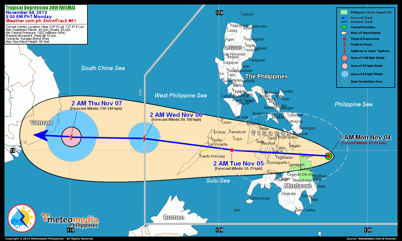
As of 5:00 am today, the center of TD 30W (Wilma) was located near the east coast of Surigao...about 155 km east-southeast of Siargao Island or 210 km East of Surigao City, Surigao Del Norte...currently moving quickly westward with a forward speed of 33 km/hr towards Siargao-Bohol Area.
Maximum Sustained Winds (1-min. avg) are at 45 km/hr near the center with higher gusts.
2-DAY FORECAST OUTLOOK*
TD 30W (Wilma) is expected to continue moving westward fast through the next 48 hours. On the forecast track, the core of TD 30W (Wilma) will traverse Central Visayas later today....passing over Bohol this afternoon...and will be over Sulu Sea, just south of Pamalican Island by early Tuesday morning. On Wednesday morning, 30W is likely to have move out of the Philippine Area of Responsibility (PAR) via Pagasa Island.
TD 30W (Wilma) will intensify within the next 24 hours as the system moves back over the warm open waters of the Sulu Sea and West Philippine Sea within the next 48 hours. Advance Intensity Forecast (AIF) shows its 1-minute maximum sustained winds increasing to 85 km/hr on Wednesday early morning.
The following is the summary of the 2-day forecast outlook and an extended 3-day forecast on this system:
TUESDAY EARLY MORNING: Maintains its strength as it emerges over the Sulu Sea...about 185 km east-southeast of San Vicente, Palawan [2AM NOV 05: 10.0N 120.9E @ 55kph].
WEDNESDAY EARLY MORNING: Over the Spratlys as it intensified into a Tropical Storm (TS) and exit PAR...about 85 km east-southeast of Pagasa Island [2AM NOV 06: 10.8N 115.0E @ 85kph].
THURSDAY EARLY MORNING: Just along the coast of Southern Vietnam...prepares to make landfall at near-Typhoon strength...about 185 km southeast of Nha Trang, Vietnam. [2AM NOV 07: 10.9N 110.1E @ 110kph].
*Please be reminded that the Forecast Outlook changes every 6 hours, and the Day 2 and 3 Forecast Track has an average error of 100 and 250 km respectively...while the wind speed forecast error, averages 35 kph per day. Therefore, a turn to the left or right of its future track and changes in its wind speed must be anticipated from time to time.
EFFECTS & HAZARDS SUMMARY
Below is the summary of the storm's parts and its hazards affecting specific areas. You can also view this image link for you to understand the parts.
DEVELOPING LOOSE RAINBANDS - where Tropical Depression Conditions with light, moderate to strong winds (30-62 kph) will be expected. Affected Areas: Northeastern Mindanao and the Visayas (click here to know more about Rainbands).
24HR TOTAL RAINFALL ACCUMULATION - from 5 up to 100 mm (slight to heavy rainfall) can be expected along areas affected by the outer & inner rainbands (see above)...with isolated amounts of 101 to 250 mm (heavy) along areas near the center of 30W (Wilma).
Important Note: Please keep in mind that the above forecast outlook, effects and hazards summary changes every 6 to 12 hrs!
CURRENT TECHNICAL INFORMATION
Time/Date: 5:00 AM PhT Mon Nov 04, 2013
Class/Name: TD 30W (Wilma)
Location of Center: Near 9.6º N Lat 127.4º E Lon
Distance 1: 155 km ESE of Siargao Island
Distance 2: 210 km E of Surigao City
Distance 3: 310 km ESE of Maasin City, Leyte
Distance 4: 390 km ESE of Metro Cebu
Distance 5: 395 km E of Tagbilaran City
MaxWinds (1-min avg): 45 kph near the center
Peak Wind Gusts: 65 kph
Present Movement: W @ 33 kph
Towards: Siargao-Bohol Area
Minimum Central Pressure: 1002 millibars (hPa)
CURRENT TRACKING MAP:
 _____________________________________________________________________________
__________________________________________________________________________________________________
CURRENT NOAA/MTSAT-2 INFRARED (IR) SATELLITE IMAGE:

__________________________________________________________________________________________________
>> To know the meteorological terminologies and acronyms used on this update visit the ff:
http://typhoon2000.ph/tcterm.htm
http://www.nhc.noaa.gov/aboutgloss.shtml
http://www.nhc.noaa.gov/acronyms.shtml
__________________________________________________________________________________________
For the complete details on TD 30W (WILMA)...go visit our website @:
> http://www.typhoon2000.com
> http://www.maybagyo.com
<<<Typhoon2000.com Mobile >>>
Get the latest SMS Storm Alerts!
For more details: Text T2K TYPHOON to
2800 (Globe/TM) | Offline (Smart/TNT) | 2288 (Sun)
*Only P2.50 (Smart/Globe) / P2.00 (Sun) per msg received.
Click here on how to use this service (in PDF file)
Powered by: Synermaxx Corporation
Copyright © 2013 Typhoon2000.com All Rights Reserved
| Reply via web post | Reply to sender | Reply to group | Start a New Topic | Messages in this topic (1) |

No comments:
Post a Comment