
for Thursday, 07 November 2013 [9:52 AM PhT]
WEATHER.COM.PH TROPICAL CYCLONE UPDATES
SUPER TYPHOON HAIYAN UPDATE NUMBER 007 (CORRECTED)
Issued at: 6:00 AM PhT (22:00 GMT) Thursday 07 November 2013
Next Update: 12:00 NN PhT (04:00 GMT) Thursday 07 November 2013
HAIYAN (YOLANDA) becomes an Extremely Catastrophic Super Typhoon and is considered as the most powerful of all Super Typhoons of 2013...now endangers Leyte and Samar Provinces..as well as the whole of Central Visayas. The potential landfall area of this super typhoon is likely along the Northern Leyte on or before noontime Friday, November 08.
Important Note: This typhoon is similar in track but more powerful in strength of Super Typhoon MIKE (RUPING) which passed across the Visayas on November 12, 1990 which devastated much of Central Visayas particularly Cebu.
Residents living along the eastern seaboards of the Philippines from Northern Quezon...Bicol Region...down to Northeastern Mindanao should continue monitoring the approach of this destructive typhoon for possible unprecendented track changes. Plans for emergency situations and/or disaster management planning must be completed as soon as possible as the dangerous cyclone is only 1 day away from hitting land.
Residents and visitors along Northeastern Mindanao, Visayas, and Bicol Region should closely monitor the development of Haiyan.
Do not use this for life or death decisions. This update is intended for additional information purposes only. Kindly refer to your national weather agency for official warnings, advisories or bulletins.
CURRENT STORM ANALYSIS [CORRECTED]
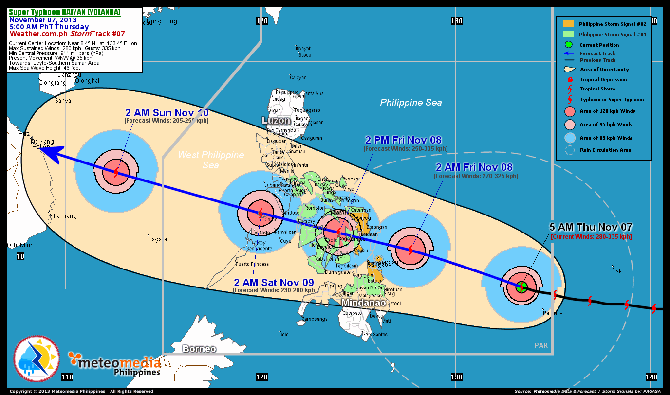
As of 5:00 am today, the eye of STY Haiyan was located over the South Philippine Sea...about 975 km southeast of Tacloban City, Leyte or 1,065 km east-southeast of Metro Cebu...currently moving very quickly west-northwest with a forward speed of 35 km/hr towards Leyte and Southern Samar Area.
Maximum Sustained Winds (1-min. avg) have rapidly increased to 280 km/hr near the center with higher gusts. Typhoon Force Winds (118 km/hr or more) extend outward up to 85 kilometers from the center...and Tropical Storm Force Winds (63-117 km/hr) extend outward up to 230 kilometers from the center. STY Haiyan remains a small-sized tropical cyclone with a diameter of 555 kilometers across.
2-DAY FORECAST OUTLOOK*
STY Haiyan is expected to move fast in a generally straight, west-northwest track throughout the forecast period. On the forecast track, the core of STY Haiyan will make landfall over the northeastern shores of Leyte, about 35 km south of Tacloban City between 10-11 AM Friday and cross Northern Leyte passing over or very close to Ormoc City around noontime Friday. This Super Typhoon will start traversing the North Central part of the Visayas Friday afternoon, passing over the northern tip of Cebu, very close to Bogo City around 2 PM...across the northern tip of Panay (along Roxas City and Boracay) Friday evening between 6 PM to 8 PM...and will be over Coron, Palawan by early Saturday Morning (approx. 2 AM). By Saturday morning, Haiyan (Yolanda) will be over the West Philippine Sea moving away from the Philippines.
STY Haiyan (Yolanda) will start to slightly weaken within the next 24 hours as the system makes landfall over North Central Visayas...and will be just a Category 4 TY on Saturday. Advance Intensity Forecast (AIF) shows its 1-minute maximum sustained winds decreasing to just 230 km/hr by early Saturday morning.
The following is the summary of the 2-day forecast outlook and an extended 3-day forecast on this system:
 FRIDAY EARLY MORNING: Weakens slightly but remains a very dangerous Category 5 Super Typhoon...approaching the eastern coast of Leyte...about 315 km east-southeast of Tacloban City, Leyte [2AM NOV 08: 10.3N 127.7E @ 270kph].
SATURDAY EARLY MORNING: Over the Calamian Group of Islands...weakens to a Category 4 Typhoon as it moves into the West Philippine Sea...about 30 km northwest of Coron, Palawan [2AM NOV 09: 12.2N 120.0E @ 230kph].
SUNDAY EARLY MORNING: Already outside of PAR...moving across the western part of the South China Sea...approaching the coast of Central Vietnam...weakens to Category 3...about 515 km southeast of Da Nang, Vietnam [2AM NOV 10: 14.3N 112.6E @ 205kph].
*Please be reminded that the Forecast Outlook changes every 6 hours, and the Day 2 and 3 Forecast Track has an average error of 100 and 250 km respectively...while the wind speed forecast error, averages 35 kph per day. Therefore, a turn to the left or right of its future track and changes in its wind speed must be anticipated from time to time.
EFFECTS & HAZARDS SUMMARY
Below is the summary of the storm's parts and its hazards affecting specific areas. You can also view this image link for you to understand the parts.
SMALL 15-KM ROUND EYE - over water. Possible calm and lull conditions (with <20 kph winds) will be expected inside the eye (click here to know more about the EYE). EYEWALL - where Typhoon Conditions with Typhoon Force Winds (>118 kph) will be expected within this wall. Affected Areas: None (click here to know more about the Eyewall). INNER RAINBANDS - where Tropical Storm Conditions with Tropical Storm Force Winds (63-100 kph) will be expected. Affected Areas: Republic of Palau. OUTER RAINBANDS - where Tropical Depression Conditions with light, moderate to strong winds (30-62 kph) will be expected. Affected Areas: Eastern Visayas and Northeastern Mindanao (click here to know more about Rainbands). 24HR TOTAL RAINFALL ACCUMULATION - from 5 up to 200 mm (slight to heavy rainfall) can be expected along areas affected by the outer & inner rainbands (see above)...with isolated amounts of 201 to 400 mm (heavy to extreme) along areas near the center of Haiyan. COASTAL STORM SURGE FLOODING - possible >18 ft (>5.5 m) above normal tide levels...accompanied by large and dangerous battering waves can be expected along the coastal, inland lakes and beach front areas of Eastern Visayas beginning tonight through Friday morning. Catastrophic damage is likely on this type of storm surge. Danger from Rip Currents or Rip Tides can be expected along the rest of the beach-front areas of Eastern Luzon, Eastern and Northern Mindanao and the rest of Visayas incl. Palawan (click here to know more about Storm Surge).-->
Important Note: Please keep in mind that the above forecast outlook, effects and hazards summary changes every 6 to 12 hrs!
CURRENT TECHNICAL INFORMATION
Time/Date: 5:00 AM PhT Thu Nov 07, 2013
Class/Name: STY Haiyan (31W)
Location of Eye: Near 8.4º N Lat 133.4º E Lon
Distance 1: 820 km ESE of Siargao Island
Distance 2: 945 km SE of Borongan City
Distance 3: 975 km SE of Tacloban City
Distance 4: 1065 km ESE of Metro Cebu
Distance 5: 1065 km ESE of Tagbilaran City
MaxWinds (1-min avg): 280 kph near the center
Peak Wind Gusts: 335 kph
Saffir-Simpson Hurricane Scale: Category 5
Present Movement: WNW @ 35 kph
Towards: Leyte-Southern Samar Area
CPA [ETA] to Leyte: Friday Morning [between 10AM-12NN PhT]
Minimum Central Pressure: 911 millibars (hPa)
T2K/WP StormTracks (for Public): GIF | Google Map (Flash)
CURRENT TRACKING MAP:
 _____________________________________________________________________________
__________________________________________________________________________________________________
CURRENT NOAA/MTSAT-2 RGB & INFRARED (IR) SATELLITE IMAGES:

 __________________________________________________________________________________________________
 >> To know the meteorological terminologies and acronyms used on this update visit the ff:
http://typhoon2000.ph/tcterm.htm
http://www.nhc.noaa.gov/aboutgloss.shtml
http://www.nhc.noaa.gov/acronyms.shtml
__________________________________________________________________________________________
For the complete details on STY HAIYAN...go visit our website @:
> http://www.typhoon2000.com
> http://www.maybagyo.com
<<<Typhoon2000.com Mobile >>>
Get the latest SMS Storm Alerts!
For more details: Text T2K TYPHOON to
2800 (Globe/TM) | Offline (Smart/TNT) | 2288 (Sun)
*Only P2.50 (Smart/Globe) / P2.00 (Sun) per msg received.
Click here on how to use this service (in PDF file)
Powered by: Synermaxx Corporation
Copyright © 2013 Typhoon2000.com All Rights Reserved
| Reply via web post | Reply to sender | Reply to group | Start a New Topic | Messages in this topic (1) |

No comments:
Post a Comment