
for Monday, 14 October 2013 [9:03 PM PhT]
WEATHER.COM.PH TROPICAL CYCLONE UPDATES
TYPHOON NARI (SANTI) UPDATE NUMBER 017
Issued at: 6:00 PM PhT (10:00 GMT) Monday 14 October 2013
Next Update: 6:00 AM PhT (22:00 GMT) Tuesday 15 October 2013
Typhoon NARI (SANTI) has weakened slightly as it continues to move closer to Central Vietnam particularly the cities of Hoi An, Da Nang and Hue, threatening these areas. Western outer rainbands are now spreading across Central Vietnam.
Meanwhile, the very large Typhoon WIPHA (TINO) has weakened into a Category 3 cyclone during the past 12 hours. As of 5:00 pm today, its eye was estimated about 1,330 km ENE of Basco, Batanes (near 23.9N 134.4E). The system has maximum sustained winds of 195 kph with higher gusts and was moving north-northwest at 26 kph in the general direction of the sea south of Japan. Various forecast models indicate this system will briefly pass the northeastern border of PAR tonight through early morning Tuesday before making a complete recurvature. Due to this development, Wipha will not affect any part of the Philippines.
Residents and visitors along Hainan Island and Central Vietnam should closely monitor the development of Nari (Santi).
Do not use this for life or death decisions. This update is intended for additional information purposes only. Kindly refer to your national weather agency for official warnings, advisories or bulletins.
CURRENT STORM ANALYSIS
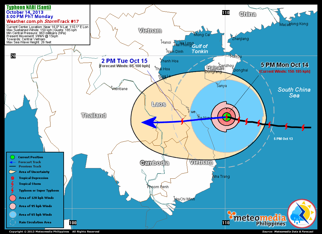
As of 5:00 pm today, the cloud-filled eye of TY Nari (Santi) was located over the western part of the South China Sea...about 205 km east of Da Nang, Vietnam or 275 km east-southeast of Hue, Vietnam...currently moving west to west-northwest with a decreased forward speed of 15 km/hr towards Central Vietnam.
Maximum Sustained Winds (1-min. avg) have slightly decreased to 150 km/hr near the center with higher gusts. Typhoon Force Winds (118 km/hr or more) extend outward up to 65 kilometers from the center...and Tropical Storm Force Winds (63-117 km/hr) extend outward up to 240 kilometers. Nari (Santi) has reduced to an average-sized tropical cyclone with a diameter of 610 kilometers across. The 24-hour rainfall accumulation near the center of Nari (Santi) is estimated to be extreme (420 mm).
1-DAY FORECAST OUTLOOK*
TY Nari (Santi) is expected to move generally westward with a west-southwest deviation on its forward track throughout the forecast period. On the forecast track, the core of Nari (Santi) will continue to move across the western portion of the South China Sea...approaching the shores of Central Vietnam by early Tuesday morning and making landfall over the cities of Hoi An and Da Nang just before daybreak. By Tuesday afternoon, Nari (Santi) will be moving across the border of Central Vietnam and Southern Laos.
TY Nari (Santi) will weaken rapidly within the next 24 hours as it interacts with the rugged terrain of Vietnam...and will gradually dissipate through 36 hours as the system continues to move over land. Advance Intensity Forecast (AIF) shows its 1-minute maximum sustained winds weakening to 85 km/hr (TS) on Tuesday afternoon.
The following is the summary of the 1-day forecast outlook on this system:
 TUESDAY AFTERNOON: Moving west to west-southwest as it bears down the coast of Central Vietnam...weakens into a Tropical Storm...about 115 km west-southwest of Da Nang, Vietnam [2PM OCT 15: 15.7N 107.2E @ 85kph].
*Please be reminded that the Forecast Outlook changes every 6 hours, and the Day 2 and 3 Forecast Track has an average error of 100 and 250 km respectively...while the wind speed forecast error, averages 35 kph per day. Therefore, a turn to the left or right of its future track and changes in its wind speed must be anticipated from time to time.
EFFECTS & HAZARDS SUMMARY
Below is the summary of the storm's parts and its hazards affecting specific areas. You can also view this image link for you to understand the parts.
CLOUD-FILLED EYE - Over the Western part of the South China Sea. Possible calm and lull conditions (with <20 kph winds) will be expected inside the eye (click here to know more about the EYE). EYEWALL - where Typhoon Conditions with Typhoon Force Winds (>118 kph) will be expected within this wall. Affected Areas: Western part of the South China Sea (click here to know more about the Eyewall). INNER RAINBANDS - where Tropical Storm Conditions with Tropical Storm Force Winds (63-100 kph) will be expected. Affected Areas: Offshore areas of Central Vietnam and the western part of the South China Sea. OUTER RAINBANDS - where Tropical Depression Conditions with light, moderate to strong winds (30-62 kph) will be expected. Affected Areas: Central Vietnam, Southern Hainan and the Western and Northwestern part of the South China Sea. (click here to know more about Rainbands). 24HR TOTAL RAINFALL ACCUMULATION - from 5 up to 200 mm (slight to heavy rainfall) can be expected along areas affected by the outer & inner rainbands (see above)...with isolated amounts of 201 to 420 mm (heavy to extreme) along areas near the center of Nari (Santi). COASTAL STORM SURGE FLOODING - possible 4-5 ft (1.2-1.7 m) above normal tide levels...accompanied by large and dangerous battering waves can be expected along the coastal, inland lakes and beach front areas of Central Vietnam beginning tonight until Tuesday. Minimal damage is likely on this type of storm surge. Danger from Rip Currents or Rip Tides can be expected along the rest of the beach-front areas Vietnam (click here to know more about Storm Surge).
Important Note: Please keep in mind that the above forecast outlook, effects and hazards summary changes every 6 to 12 hrs!
CURRENT TECHNICAL INFORMATION
Time/Date: 5:00 PM PhT Mon Oct 14, 2013
Class/Name: TY Nari (Santi)
Location of Eye: Near 16.0º N Lat 110.1º E Lon
Distance 1: 195 km E of Hoi An, Vietnam
Distance 2: 205 km E of Da Nang, Vietnam
Distance 3: 255 km SSE of Sanya, Hainan Is.
Distance 4: 275 km ESE of Hue, Vietnam
Distance 5: 1065 km WNW of Iba, Zambales
MaxWinds (1-min avg): 150 kph near the center
Peak Wind Gusts: 185 kph
Saffir-Simpson Hurricane Scale: Category 1
Present Movement: WNW @ 15 kph
Towards: Central Vietnam
24hr Rainfall Accum (Near the Center): Extreme [420 mm]
Minimum Central Pressure: 963 millibars (hPa)
Size (in Diameter): 610 km [Average]
Max Sea Wave Height (near center): 26 feet
Possible Storm Surge Height: 4-5 ft (1.2-1.7 m)
T2K/WP StormTracks (for Public): GIF | Google Map (Flash)
CURRENT TRACKING MAP:
 _____________________________________________________________________________
__________________________________________________________________________________________________
CURRENT NOAA/MTSAT-2 INFRARED (IR) SATELLITE IMAGE:

__________________________________________________________________________________________________
>> To know the meteorological terminologies and acronyms used on this update visit the ff:
http://typhoon2000.ph/tcterm.htm
http://www.nhc.noaa.gov/aboutgloss.shtml
http://www.nhc.noaa.gov/acronyms.shtml
__________________________________________________________________________________________
For the complete details on TY NARI (SANTI)...go visit our website @:
> http://www.typhoon2000.com
> http://www.maybagyo.com
<<<Typhoon2000.com Mobile >>>
Get the latest SMS Storm Alerts!
For more details: Text T2K TYPHOON to
2800 (Globe/TM) | Offline (Smart/TNT) | 2288 (Sun)
*Only P2.50 (Smart/Globe) / P2.00 (Sun) per msg received.
Click here on how to use this service (in PDF file)
Powered by: Synermaxx Corporation
Copyright © 2013 Typhoon2000.com All Rights Reserved
| Reply via web post | Reply to sender | Reply to group | Start a New Topic | Messages in this topic (1) |

No comments:
Post a Comment