
for Sunday, 13 October 2013 [9:46 AM PhT]
WEATHER.COM.PH TROPICAL CYCLONE UPDATES
TYPHOON NARI (SANTI) UPDATE NUMBER 014
Issued at: 8:00 AM PhT (00:00 GMT) Sunday 13 October 2013
Typhoon NARI (SANTI) has left the Philippine Area of Responsibility (PAR) while maintaining its generally straight but fast westerly path towards Central Vietnam...intensified slightly during the past 12 hours.
Meanwhile, a large and powerful Typhoon internationally named as WIPHA continues to move closer towards the northeastern border of the PAR. As of 5:00 am today, its eye was estimated about 1,635 km E of Santa Ana, Cagayan or 1,665 km ESE of Basco, Batanes (near 18.2N 137.6E). The system is moving north-northwest at 13 kph in the general direction of the sea south of Japan. Various forecast models suggest this system will briefly enter the PAR on Monday before making a complete recurvature. Due to this, Wipha will not affectly any part of the Philippines.
Residents and visitors along Hainan Island and Central Vietnam should closely monitor the development of Nari (Santi).
Do not use this for life or death decisions. This update is intended for additional information purposes only. Kindly refer to your national weather agency for official warnings, advisories or bulletins.
CURRENT STORM ANALYSIS
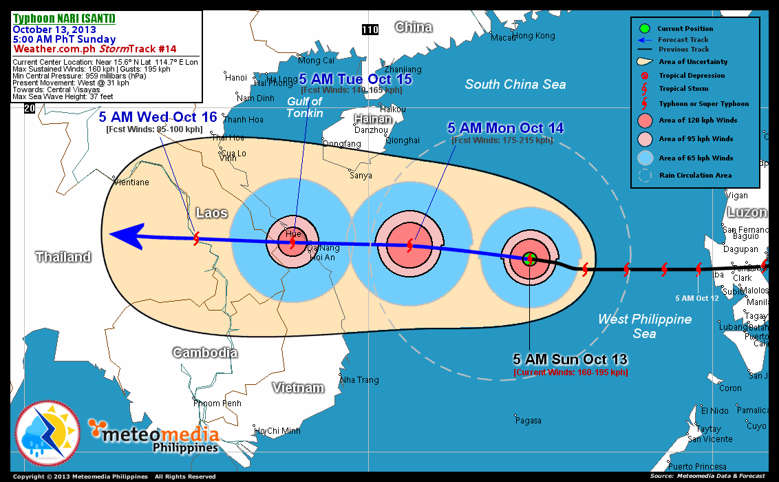
As of 5:00 am today, the cloud-filled eye of TY Nari (Santi) was located over the South China Sea...about 570 km west-northwest of Iba, Zambales or 695 km east-southeast of Da Nang, Vietnam...currently moving westward with a rapidly increased forward speed of 31 km/hr towards Central Vietnam.
Maximum Sustained Winds (1-min. avg) have increased back to 160 km/hr near the center with higher gusts. Typhoon Force Winds (118 km/hr or more) extend outward up to 65 kilometers from the center...and Tropical Storm Force Winds (63-117 km/hr) extend outward up to 165 kilometers. Nari (Santi) remains an average-sized tropical cyclone with a diameter of 610 kilometers across. The 24-hour rainfall accumulation near the center of Nari (Santi) is estimated to be extreme (500 mm).
2-DAY FORECAST OUTLOOK*
TY Nari (Santi) is expected to continue moving westward throughout the forecast period. On the forecast track, the core of Nari (Santi) will continue to move across the western portion of the South China Sea...approaching the shores of Central Vietnam on Monday morning and making landfall over the area in between the cities of Hue and Da Nang on Tuesday morning around sunrise.
TY Nari (Santi) is expected to re-intensify while over the South China Sea during the next 24 hours and will lose strength through 48 hours. Advance Intensity Forecast (AIF) shows its 1-minute maximum sustained winds increasing to 175 km/hr on Monday morning.
The following is the summary of the 2-day forecast outlook and an extended 3-day forecast on this system:
 MONDAY MORNING: Moving westward across the South China Sea...intensifies to near Category 3 status...about 320 km east of Da Nang, Vietnam [5AM OCT 14: 16.0N 111.2E @ 175kph].
TUESDAY MORNING: Makes landfall over Central Vietnam...weakens to Category 1...about 50 km south-southeast of Hue, Vietnam [5AM OCT 15: 16.1N 107.8E @ 140kph].
WEDNESDAY MORNING: Rapidly dissipating over the Laos-Thailand Border...just a Tropical Storm (TS)...about 280 km west-southwest of Hue, Vietnam [5AM OCT 16: 16.2N 105.0E @ 85kph].
*Please be reminded that the Forecast Outlook changes every 6 hours, and the Day 2 and 3 Forecast Track has an average error of 100 and 250 km respectively...while the wind speed forecast error, averages 35 kph per day. Therefore, a turn to the left or right of its future track and changes in its wind speed must be anticipated from time to time.
EFFECTS & HAZARDS SUMMARY
Below is the summary of the storm's parts and its hazards affecting specific areas. You can also view this image link for you to understand the parts.
CLOUD-FILLED EYE - Over the central part of the South China Sea. Possible calm and lull conditions (with <20 kph winds) will be expected inside the eye (click here to know more about the EYE). EYEWALL - where Typhoon Conditions with Typhoon Force Winds (>118 kph) will be expected within this wall. Affected Areas: Central part of the South China Sea (click here to know more about the Eyewall). INNER RAINBANDS - where Tropical Storm Conditions with Tropical Storm Force Winds (63-100 kph) will be expected. Affected Areas: Central part of the South China Sea. OUTER RAINBANDS - where Tropical Depression Conditions with light, moderate to strong winds (30-62 kph) will be expected. Affected Areas: Western and Central part of the South China Sea. (click here to know more about Rainbands). 24HR TOTAL RAINFALL ACCUMULATION - from 5 up to 100 mm (slight to heavy rainfall) can be expected along areas affected by the outer & inner rainbands (see above)...with isolated amounts of 101 to 500 mm (heavy to extreme) along areas near the center of Nari (Santi).
Important Note: Please keep in mind that the above forecast outlook, effects and hazards summary changes every 6 to 12 hrs!
CURRENT TECHNICAL INFORMATION
Time/Date: 5:00 AM PhT Sun Oct 13, 2013
Class/Name: TY Nari (Santi)
Location of Eye: Near 15.6º N Lat 114.7º E Lon
Distance 1: 550 km WSW of Cape Bolinao, Pangasinan
Distance 2: 570 km WNW of Iba, Zambales
Distance 3: 625 km SE of Sanya, Hainan Is.
Distance 4: 695 km ESE of Da Nang, Vietnam
Distance 5: 735 km S of Hong Kong
Distance 6: 765 km ESE of Hue, Vietnam
MaxWinds (1-min avg): 160 kph near the center
Peak Wind Gusts: 195 kph
Saffir-Simpson Hurricane Scale: Category 2
Present Movement: West @ 31 kph
Towards: Central Vietnam
24hr Rainfall Accum (Near the Center): Extreme [500 mm]
Minimum Central Pressure: 959 millibars (hPa)
Size (in Diameter): 610 km [Average]
Max Sea Wave Height (near center): 37 feet
T2K/WP StormTracks (for Public): GIF | Google Map (Flash)
CURRENT TRACKING MAP:
 _____________________________________________________________________________
__________________________________________________________________________________________________
CURRENT NOAA/MTSAT-2 INFRARED (IR) SATELLITE IMAGE:

__________________________________________________________________________________________________
>> To know the meteorological terminologies and acronyms used on this update visit the ff:
http://typhoon2000.ph/tcterm.htm
http://www.nhc.noaa.gov/aboutgloss.shtml
http://www.nhc.noaa.gov/acronyms.shtml
__________________________________________________________________________________________
For the complete details on TY NARI (SANTI)...go visit our website @:
> http://www.typhoon2000.com
> http://www.maybagyo.com
<<<Typhoon2000.com Mobile >>>
Get the latest SMS Storm Alerts!
For more details: Text T2K TYPHOON to
2800 (Globe/TM) | Offline (Smart/TNT) | 2288 (Sun)
*Only P2.50 (Smart/Globe) / P2.00 (Sun) per msg received.
Click here on how to use this service (in PDF file)
Powered by: Synermaxx Corporation
Copyright © 2013 Typhoon2000.com All Rights Reserved
| Reply via web post | Reply to sender | Reply to group | Start a New Topic | Messages in this topic (1) |

No comments:
Post a Comment