
for Thursday, 31 October 2013 [7:01 AM PhT]
WEATHER.COM.PH TROPICAL CYCLONE UPDATES
TYPHOON KROSA (VINTA) UPDATE NUMBER 008
Issued at: 6:00 AM PhT (22:00 GMT) Thursday 31 October 2013
Next Update: 12:00 NN PhT (04:00 GMT) Thursday 31 October 2013
KROSA (VINTA) has intensified rapidly into a Typhoon...endangers Cagayan, Northern Isabela, Apayao and Ilocos Norte. Landfall expected along Northern Cagayan before or after sunset.
This typhoon will continue to enhance the Northeast Monsoon (Hanging Amihan) - bringing mostly cloudy conditions w/ passing slight to moderate to sometimes heavy rains and gusty winds across Luzon including Bicol Region and Northern Visayas tonight through Thursday.
Residents and visitors along Luzon should closely monitor the development of TY Krosa (Vinta).
Do not use this for life or death decisions. This update is intended for additional information purposes only. Kindly refer to your national weather agency for official warnings, advisories or bulletins.
CURRENT STORM ANALYSIS
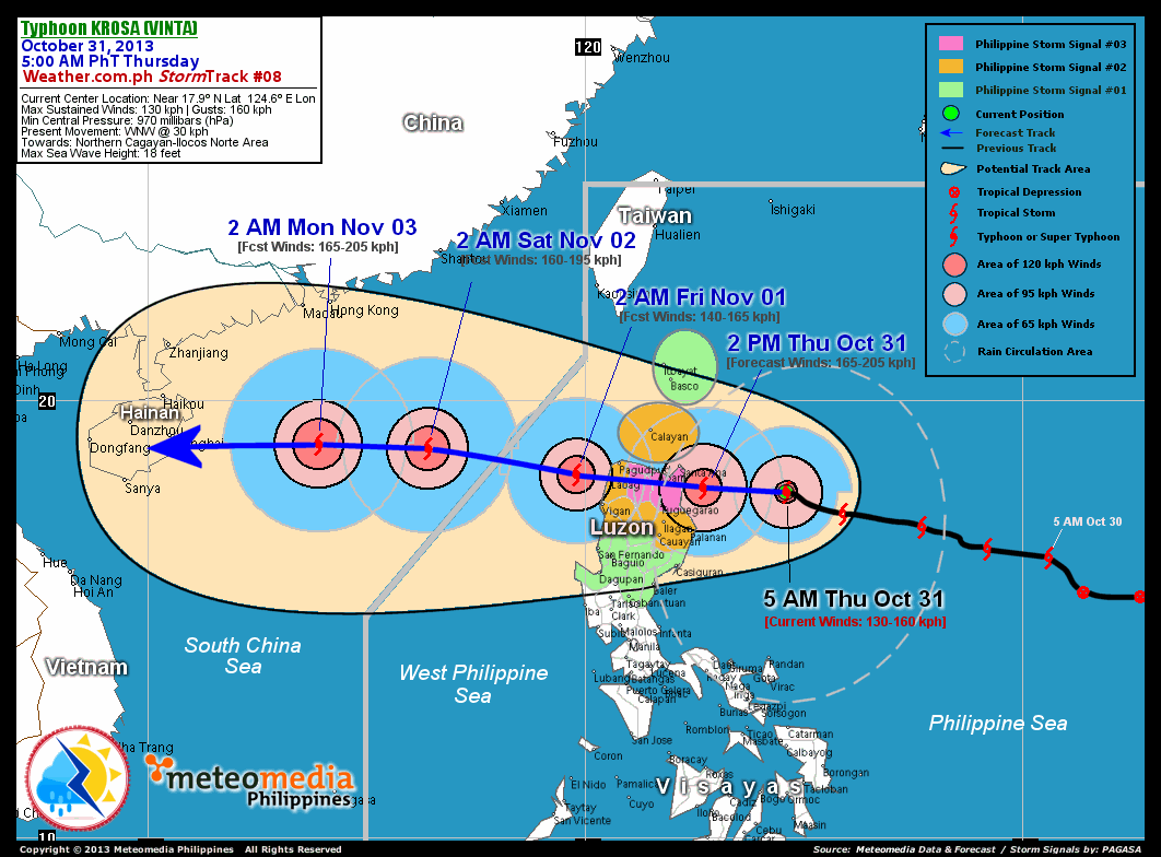
As of 5:00 am today, the eye of TY Krosa (Vinta) was located over the northwestern part of the Central Philippine Sea...about 260 km east-southeast of Santa Ana, Cagayan or 310 km east-northeast of Tuguegarao City, Cagayan...currently moving west-northwest with a forward speed of 30 km/hr towards Northern Cagayan-Ilocos Norte Area.
Maximum Sustained Winds (1-min. avg) have rapidly increased to 130 km/hr near the center with higher gusts. Typhoon Force Winds (118 km/hr or more) extend outward up to 30 kilometers from the center...and Tropical Storm Force Winds (63-117 km/hr) extend outward up to 165 kilometers. TY Krosa (Vinta) is a small-sized tropical cyclone with a diameter of 500 kilometers across.
2-DAY FORECAST OUTLOOK*
TY Krosa (Vinta) is expected to maintain a generally west to west-northwest movement throughout the forecast period. On the forecast track, the core of TY Krosa (Vinta) will be approaching the eastern coast of Cagayan this afternoon...and will make landfall over Northern Cagayan before or after sunset today (between 5-7 PM). Krosa will cross Extreme Northern Luzon thru Northern Cagayan, Northern Apayao and Ilocos Norte by Thursday evening...and will emerge over the west coast of Ilocos Norte by early Friday morning. On Friday evening, the typhoon will exit the Philippine Area of Responsibility (PAR)...and will be over the South China Sea by early Saturday morning, as it moves towards Hainan Island.
TY Krosa (Vinta) will still continue to gain strength through the next 12 hours...and could become a Category 2 Typhoon (TY) before it makes landfall over Northern Cagayan later today. Advance Intensity Forecast (AIF) shows its 1-minute maximum sustained winds increasing to a peak of 165 km/hr by this afternoon.
The following is the summary of the 2-day forecast outlook and an extended 3-day forecast on this system:
 FRIDAY EARLY MORNING: Weakens to Category 1 after crossing Extreme Northern Luzon...emerges along the west coast of Ilocos Norte...about 85 km west of Laoag City, Ilocos Norte [2AM NOV 01: 18.3N 119.8E @ 140kph].
SATURDAY EARLY MORNING: Reintensifies to Category 2 as it moves across the West Philippine and South China Seas...exits the PAR...about 440 km southeast of Hong Kong, China [2AM NOV 02: 18.9N 116.4E @ 160kph].
SUNDAY EARLY MORNING: Still intensifying as it approaches the eastern coast of Hainan Island turns more westerly...about 370 km south of Hong Kong, China [2AM NOV 03: 19.0N 113.9E @ 165kph].
*Please be reminded that the Forecast Outlook changes every 6 hours, and the Day 2 and 3 Forecast Track has an average error of 100 and 250 km respectively...while the wind speed forecast error, averages 35 kph per day. Therefore, a turn to the left or right of its future track and changes in its wind speed must be anticipated from time to time.
EFFECTS & HAZARDS SUMMARY
Below is the summary of the storm's parts and its hazards affecting specific areas. You can also view this image link for you to understand the parts.
CLOUD-FILLED EYE - over the NW part of the Central Philippine Sea. Possible calm and lull conditions (with <20 kph winds) will be expected inside the eye (click here to know more about the EYE). EYEWALL - where Typhoon Conditions with Typhoon Force Winds (>118 kph) will be expected within this wall. Affected Areas: NW part of the Central Philippine Sea (click here to know more about the Eyewall). INNER RAINBANDS - where Tropical Storm Conditions with Tropical Storm Force Winds (63-100 kph) will be expected. Affected Areas: Northern and NW part of the Central Philippine Sea. OUTER RAINBANDS - where Tropical Depression Conditions with light, moderate to strong winds (30-62 kph) will be expected. Affected Areas: Cagayan, Isabela and Northern Aurora (click here to know more about Rainbands). 24HR TOTAL RAINFALL ACCUMULATION - from 5 up to 100 mm (slight to heavy rainfall) can be expected along areas affected by the outer & inner rainbands (see above)...with isolated amounts of 101 to 250 mm (heavy) along areas near the center of Krosa (Vinta). COASTAL STORM SURGE FLOODING - possible 4-5 ft (1.2-1.7 m) above normal tide levels...accompanied by large and dangerous battering waves can be expected along the coastal, inland lakes and beach front areas of Eastern Cagayan, Eastern Isabela and Eastern Aurora today. Minimal damage is likely on this type of storm surge. Danger from Rip Currents or Rip Tides can be expected along the rest of the beach-front areas Luzon (click here to know more about Storm Surge).
Important Note: Please keep in mind that the above forecast outlook, effects and hazards summary changes every 6 to 12 hrs!
CURRENT TECHNICAL INFORMATION
Time/Date: 5:00 AM PhT Thu Oct 31, 2013
Class/Name: TY Krosa (Vinta)
Location of Eye: Near 17.9º N Lat 124.6º E Lon
Distance 1: 260 km ESE of Santa Ana, Cagayan
Distance 2: 310 km ESE of Aparri, Cagayan
Distance 3: 310 km ENE of Tuguegarao City
Distance 4: 360 km SE of Calayan Island
Distance 5: 425 km SE of Laoag City
MaxWinds (1-min avg): 130 kph near the center
Peak Wind Gusts: 160 kph
Saffir-Simpson Hurricane Scale: Category 1
Present Movement: WNW @ 30 kph
Towards: Northern Cagayan-Ilocos Norte Area
CPA [ETA] to Cagayan: Early Evening Today [between 5PM-7PM PhT]
Minimum Central Pressure: 970 millibars (hPa)
T2K/WP StormTracks (for Public): GIF | Google Map (Flash)
CURRENT TRACKING MAP:
 _____________________________________________________________________________
__________________________________________________________________________________________________
CURRENT NOAA/MTSAT-2 INFRARED (IR) SATELLITE IMAGE:

__________________________________________________________________________________________________
>> To know the meteorological terminologies and acronyms used on this update visit the ff:
http://typhoon2000.ph/tcterm.htm
http://www.nhc.noaa.gov/aboutgloss.shtml
http://www.nhc.noaa.gov/acronyms.shtml
__________________________________________________________________________________________
For the complete details on TS KROSA (VINTA)...go visit our website @:
> http://www.typhoon2000.com
> http://www.maybagyo.com
<<<Typhoon2000.com Mobile >>>
Get the latest SMS Storm Alerts!
For more details: Text T2K TYPHOON to
2800 (Globe/TM) | Offline (Smart/TNT) | 2288 (Sun)
*Only P2.50 (Smart/Globe) / P2.00 (Sun) per msg received.
Click here on how to use this service (in PDF file)
Powered by: Synermaxx Corporation
Copyright © 2013 Typhoon2000.com All Rights Reserved
| Reply via web post | Reply to sender | Reply to group | Start a New Topic | Messages in this topic (1) |

No comments:
Post a Comment