
for Tuesday, 15 October 2013 [6:52 PM PhT]
WEATHER.COM.PH TROPICAL CYCLONE UPDATES
TROPICAL STORM NARI (SANTI) UPDATE NUMBER 019 [FINAL]
Issued at: 6:00 PM PhT (10:00 GMT) Tuesday 15 October 2013
NARI (SANTI) has weakened rapidly into a Tropical Storm (TS) after it made landfall over Central Vietnam this morning...now moving southwestward across Southern Laos. Strong winds and heavy rains affecting Southern Laos, Northern Cambodia and Eastern Thailand.
Meanwhile, Typhoon WIPHA (TINO) has completed its recurvature and is now moving quickly towards Southeastern Honshu (Japan). As of 5:00 pm today, its eye was estimated about 790 km SE of Tokyo, Japan (near 29.5N 135.6E). Its maximum winds has weakened to 150 kph near the center with higher gusts and was moving north-northeast at 30 kph in the general direction of Southeastern Honshu.
*This is the last and final update on Nari (Santi).
Do not use this for life or death decisions. This update is intended for additional information purposes only. Kindly refer to your national weather agency for official warnings, advisories or bulletins.
CURRENT STORM ANALYSIS
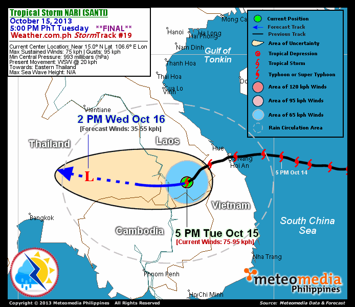
As of 5:00 pm today, the center of TS Nari (Santi) was located over Southern Laos...about 200 km south-southwest of Hue, Vietnam or 420 km north-northeast of Phnom Penh, Cambodia...currently moving west-southwest with a forward speed of 20 km/hr towards Eastern Thailand.
Maximum Sustained Winds (1-min. avg) have rapidly decreased to 75 km/hr near the center with higher gusts. Tropical Storm Force Winds (63-117 km/hr) extend outward up to 95 kilometers from the center. Nari (Santi) is an average-sized tropical cyclone with a diameter of 650 kilometers across. The 24-hour rainfall accumulation near the center of Nari (Santi) is estimated to be heavy (250 mm).
1-DAY FORECAST OUTLOOK*
TS Nari (Santi) is expected to resume moving westward throughout the forecast period. On the forecast track, the core of Nari (Santi) will make its way across Eastern Thailand on Wednesday afternoon.
TS Nari (Santi) will weaken rapidly within the next 12 hours as it interacts with the rugged terrains of Southern Laos and Eastern Thailand...and will gradually dissipate through 24 hours as the system continues to move over land. Advance Intensity Forecast (AIF) shows its 1-minute maximum sustained winds weakening to 35 km/hr (LPA) on Wednesday afternoon.
The following is the summary of the 1-day forecast outlook on this system:
 WEDNESDAY AFTERNOON: Moving west across Eastern Thailand...dissipates into an area of low pressure...about 285 km northeast of Phnom Penh, Cambodia [2PM OCT 16: 15.2N 102.7E @ 35kph].
*Please be reminded that the Forecast Outlook changes every 6 hours, and the Day 2 and 3 Forecast Track has an average error of 100 and 250 km respectively...while the wind speed forecast error, averages 35 kph per day. Therefore, a turn to the left or right of its future track and changes in its wind speed must be anticipated from time to time.
EFFECTS & HAZARDS SUMMARY
Below is the summary of the storm's parts and its hazards affecting specific areas. You can also view this image link for you to understand the parts.
INNER RAINBANDS - where Tropical Storm Conditions with Tropical Storm Force Winds (63-100 kph) will be expected. Affected Areas: Southern Laos, Northern Cambodia and Easternmost part of Eastern Thailand. OUTER RAINBANDS - where Tropical Depression Conditions with light, moderate to strong winds (30-62 kph) will be expected. Affected Areas: Rest of Cambodia, Central and Southern Vietnam, and the Central part of Eastern Thailand. (click here to know more about Rainbands). 24HR TOTAL RAINFALL ACCUMULATION - from 5 up to 100 mm (slight to heavy rainfall) can be expected along areas affected by the outer & inner rainbands (see above)...with isolated amounts of 101 to 250 mm (heavy) along areas near the center of Nari (Santi).
Important Note: Please keep in mind that the above forecast outlook, effects and hazards summary changes every 6 to 12 hrs!
CURRENT TECHNICAL INFORMATION
Time/Date: 5:00 PM PhT Tue Oct 15, 2013
Class/Name: TS Nari (Santi)
Location of Eye: Near 15.0º N Lat 106.6º E Lon
Distance 1: 200 km SSW of Hue, Vietnam
Distance 2: 205 km SW of Hoi An, Vietnam
Distance 3: 210 km SW of Da Nang, Vietnam
Distance 4: 420 km NNE of Phnom Penh, Cambodia
MaxWinds (1-min avg): 75 kph near the center
Peak Wind Gusts: 95 kph
Present Movement: WSW @ 20 kph
Towards: Eastern Thailand
24hr Rainfall Accum (Near the Center): Heavy [250 mm]
Minimum Central Pressure: 993 millibars (hPa)
Size (in Diameter): 650 km [Average]
Max Sea Wave Height (near center): N/A (Overland)
T2K/WP StormTracks (for Public): GIF | Google Map (Flash)
CURRENT TRACKING MAP:
 _____________________________________________________________________________
__________________________________________________________________________________________________
CURRENT NOAA/MTSAT-2 INFRARED (IR) SATELLITE IMAGE:

__________________________________________________________________________________________________
>> To know the meteorological terminologies and acronyms used on this update visit the ff:
http://typhoon2000.ph/tcterm.htm
http://www.nhc.noaa.gov/aboutgloss.shtml
http://www.nhc.noaa.gov/acronyms.shtml
__________________________________________________________________________________________
For the complete final details on TS NARI (SANTI)...go visit our website @:
> http://www.typhoon2000.com
> http://www.maybagyo.com
<<<Typhoon2000.com Mobile >>>
Get the latest SMS Storm Alerts!
For more details: Text T2K TYPHOON to
2800 (Globe/TM) | Offline (Smart/TNT) | 2288 (Sun)
*Only P2.50 (Smart/Globe) / P2.00 (Sun) per msg received.
Click here on how to use this service (in PDF file)
Powered by: Synermaxx Corporation
Copyright © 2013 Typhoon2000.com All Rights Reserved
| Reply via web post | Reply to sender | Reply to group | Start a New Topic | Messages in this topic (1) |

No comments:
Post a Comment