
for Tuesday, 01 October 2013 [11:12 PM PhT]
WEATHER.COM.PH TROPICAL CYCLONE UPDATES
TROPICAL STORM FITOW (QUEDAN) UPDATE NUMBER 002
Issued at: 6:45 PM PhT (11:45 GMT) Tuesday 01 October 2013
Tropical Storm FITOW (QUEDAN) has slightly gained strength as it continues to move generally northward slowly across the Philippine Sea. It will not directly affect any part of the country. .
Residents and visitors along the southern islands of Japan should closely monitor the development of FITOW (Quedan).
Do not use this for life or death decisions. This update is intended for additional information purposes only. Kindly refer to your national weather agency for official warnings, advisories or bulletins.
CURRENT STORM ANALYSIS
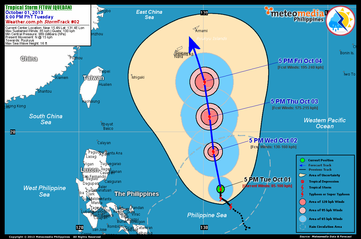
As of 5:00 pm today, the center of TS Fitow (Quedan) was located over the Central Philippine Sea...about 790 km east-northeast of Virac, Catanduanes or 1,000 km east-southeast of Casiguran, Aurora...currently moving north with a slow forward speed of 15 km/hr towards Ryukyus.
Maximum Sustained Winds (1-min. avg) are at 85 km/hr near the center with higher gusts. Tropical Storm Force Winds (63-117 km/hr) extend outward up to 110 kilometers from the center. Fitow (Quedan) remains an average-sized tropical cyclone with a diameter of 500 kilometers across. The 24-hour rainfall accumulation near the center of Fitow (Quedan) is estimated to be extreme (325 mm).
2-DAY FORECAST OUTLOOK*
TS Fitow (Quedan) is expected to move north-northwest during the next 24 to 48 hours. On the forecast track, the core of Fitow (Quedan) will be moving across the eastern and northern parts of the Philippine Sea thru Thursday.
TS Fitow (Quedan) will continue to gain strength during the next 24 hours...and could become a Typhoon (TY) on Wednesday afternoon. Advance Intensity Forecast (AIF) shows its 1-minute maximum sustained winds increasing to 175 km/hr on Thursday afternoon.
The following is the summary of the 2-day forecast outlook and an extended 3-day forecast on this system:
 WEDNESDAY AFTERNOON: Becomes a Category 1 Typhoon as it moves north-northwest across the northern part of Central Philippine Sea...about 890 km east of Santa Ana, Cagayan [5PM OCT 02: 18.4N 130.8E @ 130kph].
THURSDAY AFTERNOON: Intensifies into a Category 2 Typhoon as it continues to move north-northwest...about 885 km east-northeast of Basco, Batanes [5PM OCT 03: 21.2N 130.5E @ 175kph].
FRIDAY AFTERNOON: Strengthens into a Category 3 Typhoon as it moves closer to Ryukyu Islands...about 360 km southeast of Okinawa, Okinawa [5PM OCT 04: 24.0N 130.1E @ 195kph].
*Please be reminded that the Forecast Outlook changes every 6 hours, and the Day 2 and 3 Forecast Tracks have an average error of 100 and 250 km respectively...while the wind speed forecast error, averages 35 kph per day. Therefore, a turn to the left or right of its future track and changes in its wind speed must be anticipated from time to time.
EFFECTS & HAZARDS SUMMARY
Below is the summary of the storm's parts and its hazards affecting specific areas. You can also view this image link for you to understand the parts.
INNER RAINBANDS - where Tropical Storm Conditions with Tropical Storm Force Winds (63-100 kph) will be expected. Affected Areas: Northeastern part of Central Philippine Sea. OUTER RAINBANDS - where Tropical Depression Conditions with light, moderate to strong winds (30-62 kph) will be expected. Affected Areas: Central and eastern portions of Philippine Sea. (click here to know more about Rainbands). 24HR TOTAL RAINFALL ACCUMULATION - from 5 up to 100 mm (slight to heavy rainfall) can be expected along areas affected by the outer & inner rainbands (see above)...with isolated amounts of 101 to 325 mm (heavy to extreme) along areas near the center of Fitow (Quedan).
Important Note: Please keep in mind that the above forecast outlook, effects and hazards summary changes every 6 to 12 hrs!
CURRENT TECHNICAL INFORMATION
Time/Date: 5:00 PM PhT Tue Oct 01, 2013
Class/Name: TS Fitow (Quedan)
Location of Center: Near 15.4º N Lat 131.4º E Lon
Distance 1: 790 km ENE of Virac, Catanduanes
Distance 2: 1,000 km ESE of Casiguran, Aurora
Distance 3: 1,120 km ENE of Metro Manila
Distance 4: 975 km ESE of Palanan, Isabela
Distance 5: 1,045 km ESE of Santa Ana, Cagayan
MaxWinds (1-min avg): 85 kph near the center
Peak Wind Gusts: 100 kph
Present Movement: N @ 15 kph
Towards: Ryukyus
24hr Rainfall Accum (Near the Center): Extreme [325 mm]
Minimum Central Pressure: 989 millibars (hPa)
Size (in Diameter): 500 km [Average]
Max Sea Wave Height (near center): 16 feet
T2K/WP StormTracks (for Public): GIF | Google Map (Flash)
CURRENT TRACKING MAP:
 _____________________________________________________________________________
__________________________________________________________________________________________________
CURRENT NOAA/MTSAT-2 INFRARED (IR) SATELLITE IMAGE:
 __________________________________________________________________________________________________
 >> To know the meteorological terminologies and acronyms used on this update visit the ff:
http://typhoon2000.ph/tcterm.htm
http://www.nhc.noaa.gov/aboutgloss.shtml
http://www.nhc.noaa.gov/acronyms.shtml
__________________________________________________________________________________________
For the complete details on TS FITOW (QUEDAN)...go visit our website @:
> http://www.typhoon2000.com
> http://www.maybagyo.com
<<<Typhoon2000.com Mobile >>>
Get the latest SMS Storm Alerts!
For more details: Text T2K TYPHOON to
2800 (Globe/TM) | Offline (Smart/TNT) | 2288 (Sun)
*Only P2.50 (Smart/Globe) / P2.00 (Sun) per msg received.
Click here on how to use this service (in PDF file)
Powered by: Synermaxx Corporation
Copyright © 2013 Typhoon2000.com All Rights Reserved
| Reply via web post | Reply to sender | Reply to group | Start a New Topic | Messages in this topic (1) |

No comments:
Post a Comment