
for Thursday, 19 September 2013 [8:27 AM PhT]
WEATHER.COM.PH TROPICAL CYCLONE UPDATES
TYPHOON USAGI (ODETTE) UPDATE NUMBER 007
Issued at: 7:45 AM PhT (23:45 GMT) Thursday 19 September 2013
USAGI (ODETTE) is now a Category 2 Typhoon (TY) after it rapidly intensified overnight while over the Philippine Sea...threat to Northern Luzon and Taiwan increases.
This typhoon will continue to enhance the Southwest Monsoon (Hanging Habagat) - bringing mostly cloudy and windy conditions with occasional slight to moderate to sometimes heavy rains or thunderstorms across MiMaRoPa and Western Visayas today...will start to affect Western & Central Luzon including Metro Manila and CaLaBaRZon beginning Friday thru Sunday. The threat of flash floods and landslides are likely in hazard-prone areas especially along river banks and mountain slopes of the affected areas. Residents are advised to take necessary precautions.
Meanwhile, Tropical Depression 18W has rapidly accelerated and made landfall over Central Vietnam...dissipating over land. Its center was located about 1,365 km west-northwest of Dagupan City, Pangasinan or 10 km west of Hue, Vietnam (16.5N Lat 107.5E Lon)...with maximum winds of 45 km/hr near the center...currently moving west at 24 kph towards Laos.
Residents and visitors along Northern Luzon and Taiwan should closely monitor the development of Usagi (Odette).
Do not use this for life or death decisions. This update is intended for additional information purposes only. Kindly refer to your national weather agency for official warnings, advisories or bulletins.
CURRENT STORM ANALYSIS
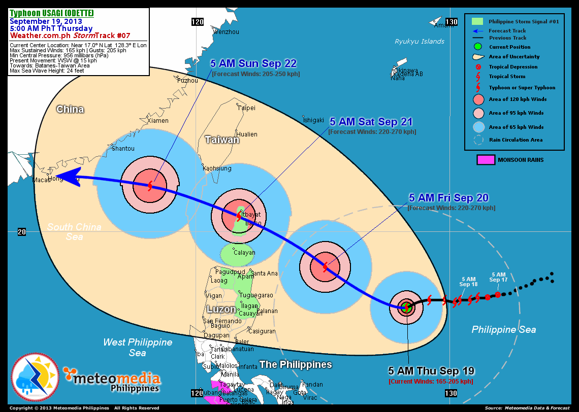
As of 5:00 am today, the eye of TY Usagi (Odette) was located over the north central part of the Philippine Sea...about 625 km east of Palanan, Isabela or 665 km east-southeast of Santa Ana, Cagayan...currently moving west to west-southwest with a forward speed of 15 km/hr towards Batanes-Taiwan Area.
Maximum Sustained Winds (1-min. avg) have rapidly increased to 165 km/hr near the center with higher gusts. Typhoon Force Winds (118 km/hr or more) extend outward up to 35 kilometers from the center...and Tropical Storm Force Winds (63-117 km/hr) extend outward up to 160 kilometers. Usagi (Odette) has grown into a large-sized tropical cyclone with a diameter of 890 kilometers across. The 24-hour rainfall accumulation near the center of Usagi (Odette) is estimated to be extreme (400 mm).
2-DAY FORECAST OUTLOOK*
TY Usagi (Odette) is expected to move west-northwest to northwest during the next 24 hours...turning back to west-northwestward through 48 hours. On the forecast track, the core of Usagi (Odette) will remain over the open waters of the Philippine Sea as it moves closer to Extreme Northern Luzon on Friday...and will over the Batanes Islands on Saturday morning.
TY Usagi (Odette) will continue to intensify during the next 24 to 48 hours...and could become a Category 4 TY by Friday morning. Advance Intensity Forecast (AIF) shows its 1-minute sustained winds increasing to 230 km/hr on Friday afternoon.
The following is the summary of the 2-day forecast outlook and an extended 3-day forecast on this system:
 FRIDAY MORNING: Becomes a Category 4 TY as it moves west-northwest to northwest across the north central part of the Philippine Sea...about 305 km east of Santa Ana, Cagayan [5AM SEP 20: 18.6N 125.1E @ 220kph].
SATURDAY MORNING: Maintains its strength as it moves across the Batanes Islands into the Bashi Channel...about 25 km south-southwest of Itbayat, Batanes [5AM SEP 21: 20.6N 121.7E @ 220kph].
SUNDAY MORNING: Exits the Philippine Area of Responsibility (PAR) as it moves across the South China Sea towards Hong Kong...weakens to a Category 3 TY...about 415 km east-southeast of Hong Kong, China [5AM SEP 22: 21.8N 118.2E @ 205kph].
*Please be reminded that the Forecast Outlook changes every 6 hours, and the Day 2 and 3 Forecast Tracks have an average error of 100 and 250 km respectively...while the wind speed forecast error, averages 35 kph per day. Therefore, a turn to the left or right of its future track and changes in its wind speed must be anticipated from time to time.
EFFECTS & HAZARDS SUMMARY
Below is the summary of the storm's parts and its hazards affecting specific areas. You can also view this image link for you to understand the parts.
CLOUD-FILLED + RAGGED EYE - Over the North Central part of the Philippine Sea. Possible calm and lull conditions (with <20 kph winds) will be expected inside the eye (click here to know more about the EYE). EYEWALL - where Typhoon Conditions with Typhoon Force Winds (>118 kph) will be expected within this wall. Affected Areas: North Central Part of the Philippine Sea (click here to know more about the Eyewall). INNER RAINBANDS - where Tropical Storm Conditions with Tropical Storm Force Winds (63-100 kph) will be expected. Affected Areas: North Central Part of the Philippine Sea OUTER RAINBANDS - where Tropical Depression Conditions with light, moderate to strong winds (30-62 kph) will be expected. Affected Areas: The northern coastal areas of Bicol Region (click here to know more about Rainbands). 24HR TOTAL RAINFALL ACCUMULATION - from 5 up to 199 mm (slight to heavy rainfall) can be expected along areas affected by the outer & inner rainbands (see above)...with isolated amounts of 200 to 400 mm (heavy to extreme) along areas near the center of Usagi (Odette). COASTAL STORM SURGE FLOODING - possible 6-8 ft (1.8-2.6 m) above normal tide levels...accompanied by large and dangerous battering waves can be expected along the coastal, inland lakes and beach front areas of Northern Luzon and Batanes-Calayan-Babuyan Islands beginning Friday through Saturday. Minimal damage is likely on this type of storm surge. Danger from Rip Currents or Rip Tides can be expected along the rest of the beach-front areas of Luzon, Bicol Region and Taiwan (click here to know more about Storm Surge).
Important Note: Please keep in mind that the above forecast outlook, effects and hazards summary changes every 6 to 12 hrs!
CURRENT TECHNICAL INFORMATION
Time/Date: 5:00 AM PhT Thu Sep 19, 2013
Class/Name: TY Usagi (Odette)
Location of Eye: Near 17.0º N Lat 128.3º E Lon
Distance 1: 625 km E of Palanan, Isabela
Distance 2: 665 km ESE of Santa Ana, Cagayan
Distance 3: 705 km ESE of Tuguegarao City
Distance 4: 760 km SE of Calayan Island
Distance 5: 780 km SE of Basco, Batanes
MaxWinds (1-min avg): 165 kph near the center
Peak Wind Gusts: 205 kph
Saffir-Simpson Hurricane Scale: Category 2
Present Movement: WSW @ 15 kph
Towards: Batanes-Taiwan Area
CPA [ETA] to Batanes: Saturday Morning [2AM-6AM PhT]
24hr Rainfall Accum (Near the Center): Extreme [400 mm]
Minimum Central Pressure: 956 millibars (hPa)
Size (in Diameter): 890 km [Large]
Max Sea Wave Height (near center): 24 feet
Possible Storm Surge Height: 6-8 ft (1.8-2.6 m)
T2K/WP StormTracks (for Public): GIF | Google Map (Flash)
CURRENT TRACKING MAP:
 _____________________________________________________________________________
__________________________________________________________________________________________________
CURRENT NOAA/MTSAT-2 INFRARED (IR) SATELLITE IMAGE:

__________________________________________________________________________________________________
>> To know the meteorological terminologies and acronyms used on this update visit the ff:
http://typhoon2000.ph/tcterm.htm
http://www.nhc.noaa.gov/aboutgloss.shtml
http://www.nhc.noaa.gov/acronyms.shtml
__________________________________________________________________________________________
For the complete details on TY USAGI (ODETTE)...go visit our website @:
> http://www.typhoon2000.com
> http://www.maybagyo.com
<<<Typhoon2000.com Mobile >>>
Get the latest SMS Storm Alerts!
For more details: Text T2K TYPHOON to
2800 (Globe/TM) | Offline (Smart/TNT) | 2288 (Sun)
*Only P2.50 (Smart/Globe) / P2.00 (Sun) per msg received.
Click here on how to use this service (in PDF file)
Powered by: Synermaxx Corporation
Copyright © 2013 Typhoon2000.com All Rights Reserved
| Reply via web post | Reply to sender | Reply to group | Start a New Topic | Messages in this topic (1) |

No comments:
Post a Comment