
for Friday, 13 September 2013 [12:28 PM PhT]
WEATHER.COM.PH TROPICAL CYCLONE UPDATES
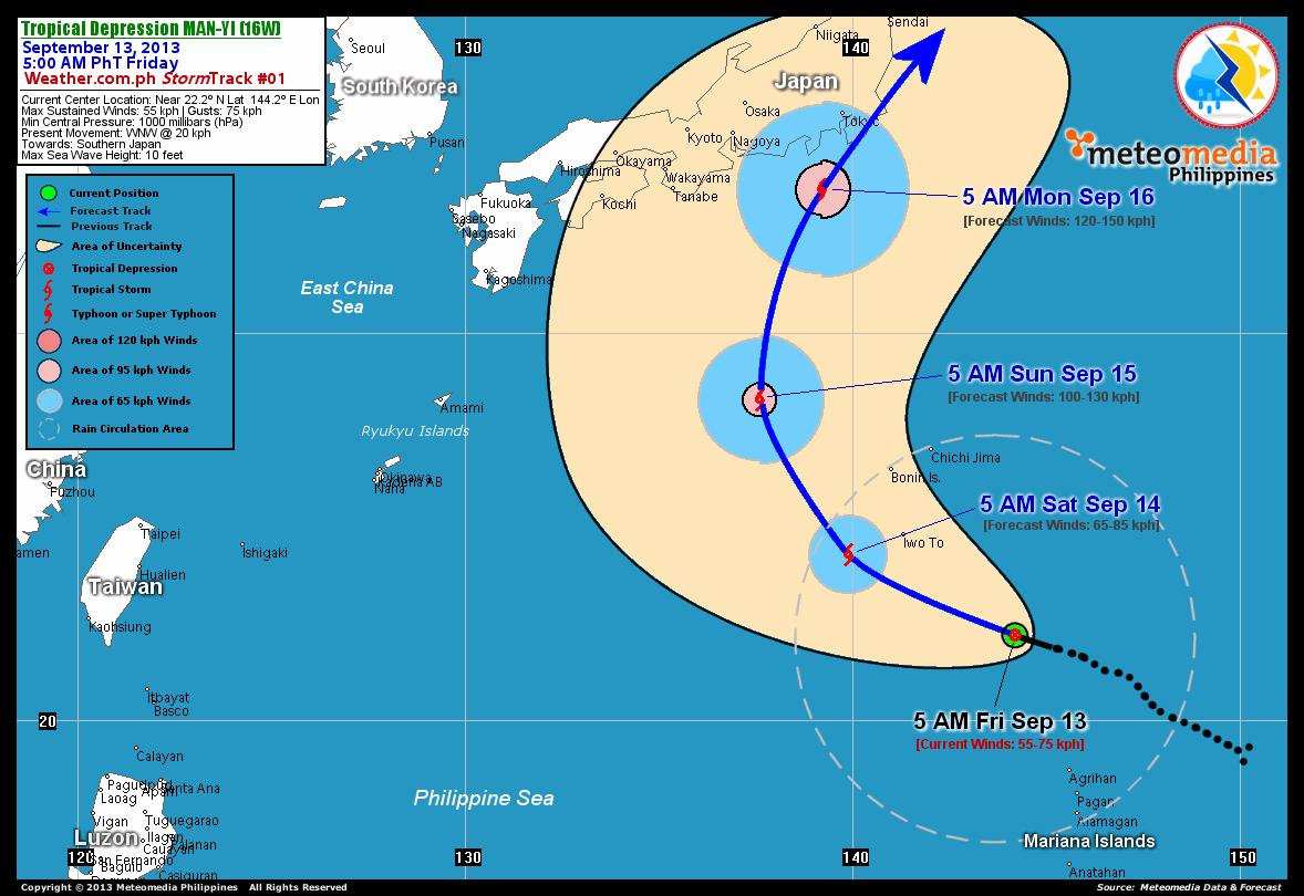
TROPICAL DEPRESSION MAN-YI (16W) UPDATE NUMBER 001
Issued at: 9:00 AM PhT (01:00 GMT) Friday 13 September 2013
Tropical Depression MAN-YI (16W) newly-formed to the north of Guam and the Marianas...may pose a threat to Japan this weekend.
Residents and visitors along Southern Japan should closely monitor the development of Man-yi (16W).
Do not use this for life or death decisions. This update is intended for additional information purposes only. Kindly refer to your national weather agency for official warnings, advisories or bulletins.
CURRENT STORM ANALYSIS
As of 5:00 am today, the center of TD Man-yi (16W) was located over the Western Pacific Ocean...about 415 km southeast of Iwo To, Japan or 2,305 km east-northeast of Basco, Batanes...currently moving west-northwest with a forward speed of 20 km/hr towards Southern Japan.
Maximum Sustained Winds (1-min. avg) are at 55 km/hr near the center with higher gusts. Man-yi (16W) is an average-sized tropical cyclone with a diameter of 555 kilometers across. The 24-hour rainfall accumulation near the center of Man-yi is estimated to be heavy (330 mm).
2-DAY FORECAST OUTLOOK*
TD Man-yi (16W) is expected to move west-northwest during the next 24 hours...with a gradual increase in forward speed as it turns northwesterly through 48 hours. On the forecast track, the core of Man-Yi will pass just to the west of Iwo To Island on Saturday...and over the open seas on Sunday.
TD Man-yi will continue to strengthen during the next 48 hours...and could become a Tropical Storm (TS) on Saturday. Advance Intensity Forecast (AIF) shows its 1-minute sustained winds increasing to 100 km/hr on Sunday morning.
The following is the summary of the 2-day forecast outlook and an extended 3-day forecast on this system:
 SATURDAY MORNING: Strengthens to a TS as it starts moving northwestward...about 150 km WSW of Iwo To, Japan [5AM SEP 14: 24.3N 139.9E @ 65kph].
SUNDAY MORNING: Continues to gain strength as it turns northward across the Western Pacific Ocean...about 635 km south-southeast of Tanabe, Japan [5AM SEP 15: 28.3N 137.6E @ 100kph].
MONDAY MORNING: Becomes a Typhoon as it approaches the shores of Southern Honshu...about 225 km south-southwest of Tokyo, Japan [5AM SEP 16: 33.7N 139.2E @ 120kph].
*Please be reminded that the Forecast Outlook changes every 6 hours, and the Day 2 and 3 Forecast Tracks have an average error of 100 and 250 km respectively...while the wind speed forecast error, averages 35 kph per day. Therefore, a turn to the left or right of its future track and changes in its wind speed must be anticipated from time to time.
EFFECTS & HAZARDS SUMMARY
Below is the summary of the storm's parts and its hazards affecting specific areas. You can also view this image link for you to understand the parts.
DEVELOPING RAINBANDS - where Tropical Depression Conditions with light, moderate to strong winds (30-62 kph) will be expected. Affected Areas: Northernmost Mariana Islands, Iwo To, Bonin and Chichijima Islands (click here to know more about Rainbands). 24HR TOTAL RAINFALL ACCUMULATION - from 5 up to 100 mm (slight to heavy rainfall) can be expected along areas affected by the outer & inner rainbands (see above)...with isolated amounts of 101 to 330 mm (heavy to extreme) along areas to the south, northwest and near the center of Man-yi (16W).
Important Note: Please keep in mind that the above forecast outlook, effects and hazards summary changes every 6 to 12 hrs!
CURRENT TECHNICAL INFORMATION
Time/Date: 5:00 AM PhT Fri Sep 13, 2013
Class/Name: TD Man-yi (16W)
Location of Center: Near 22.2º N Lat 144.2º E Lon
Distance 1: 415 km SE of Iwo To, Japan
Distance 2: 415 km NNW of Agrihan Is., CNMI
Distance 3: 580 km SSE of Chichijima
Distance 4: 1565 km SSE of Tokyo, Japan
Distance 5: 2305 km ENE of Basco, Batanes
MaxWinds (1-min avg): 55 kph near the center
Peak Wind Gusts: 75 kph
Present Movement: WNW @ 20 kph
Towards: Southern Japan
24hr Rainfall Accum (Near the Center): Heavy [330 mm]
Minimum Central Pressure: 1000 millibars (hPa)
Size (in Diameter): 555 km [Average]
Max Sea Wave Height (near center): 10 feet
T2K/WP StormTracks (for Public): GIF | Google Map (Flash)
CURRENT TRACKING MAP:
 _____________________________________________________________________________
__________________________________________________________________________________________________
CURRENT NOAA/MTSAT-2 INFRARED (IR) SATELLITE IMAGE:

__________________________________________________________________________________________________
>> To know the meteorological terminologies and acronyms used on this update visit the ff:
http://typhoon2000.ph/tcterm.htm
http://www.nhc.noaa.gov/aboutgloss.shtml
http://www.nhc.noaa.gov/acronyms.shtml
__________________________________________________________________________________________
For the complete details on TD MAN-YI (16W)...go visit our website @:
> http://www.typhoon2000.com
> http://www.maybagyo.com
<<<Typhoon2000.com Mobile >>>
Get the latest SMS Storm Alerts!
For more details: Text T2K TYPHOON to
2800 (Globe/TM) | Offline (Smart/TNT) | 2288 (Sun)
*Only P2.50 (Smart/Globe) / P2.00 (Sun) per msg received.
Click here on how to use this service (in PDF file)
Powered by: Synermaxx Corporation
Copyright © 2013 Typhoon2000.com All Rights Reserved
| Reply via web post | Reply to sender | Reply to group | Start a New Topic | Messages in this topic (1) |

No comments:
Post a Comment