
for Monday, 12 August 2013 [8:03 AM PhT]
WEATHER.COM.PH TROPICAL CYCLONE UPDATES
TYPHOON UTOR (LABUYO) UPDATE NUMBER 011
Issued: 6:00 AM PhT (22:00 GMT) Monday 12 August 2013
Next Update: 12:00 NN PhT (04:00 GMT) Monday 12 August 2013
Super Typhoon UTOR (LABUYO) weakens after it made landfall over Casiguran, Aurora early this morning...now moving over Quirino and Nueva Vizcaya...will be over Benguet in the next hour or two. Stormy weather will continue throughout the day across Northern Luzon. Its outer rainbands will continue to affect Central Luzon including Metro Manila.
This typhoon will continue to enhance the Southwest Monsoon (Hanging Habagat) bringing cloudy conditions with occasionally slight to moderate to sometimes heavy rains and thunderstorms across Western Visayas and MiMaRoPa today. Flash floods and landslides are likely in hazard-prone areas especially along river banks and mountain slopes.
Residents and visitors along Luzon should closely monitor the development of Utor (Labuyo).
Do not use this for life or death decisions. This update is intended for additional information purposes only. Kindly refer to your national weather agency for official warnings, advisories or bulletins.
CURRENT STORM ANALYSIS
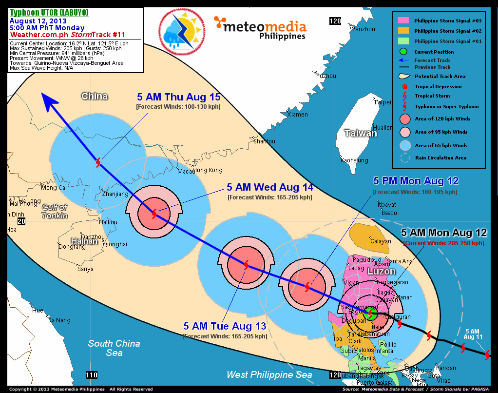
As of 5:00 am today, the center of Typhoon Utor (Labuyo) was located over the Quirino-Nueva Vizcaya Norder...about 80 km south of Cauayan City, Isabela or 110 km east-southeast of Baguio City, Benguet...currently moving west-northwest with an increased forward speed of 28 km/hr towards of Benguet and La Union.
Maximum Sustained Winds (1-min. avg) have rapidly decreased to near 205 km/hr near the center with higher gusts. Typhoon Force Winds (118 km/hr or more) extend outward up to 95 kilometers from the center...and Tropical Storm Force Winds (63-117 km/hr) extend outward up to 295 kilometers. A Meteomedia/WeatherPhilippines Weather Station located in Baler, Aurora (LPP), recorded wind gusts of 91 km/hr blowing from the south.--> Utor (Labuyo) is an average-sized tropical cyclone with a diameter of 555 kilometers across. The 24-hour rainfall accumulation near the center of Utor (Labuyo) is estimated to be heavy (350 mm).
2-DAY FORECAST OUTLOOK*
Typhoon Utor (Labuyo) is expected to continue moving west-northwestward throughout the forecast period. On the forecast track, the core of Utor (Labuyo) will emerge over the west coast of La Union before noon today and move across the West Philippine Sea, away from Northern Luzon this afternoon. By Tuesday morning, Utor will move out of the Philippine Area of Responsibility (PAR)...and will be approaching the coast of Western Guangdong on Wednesday morning.
Utor (Labuyo) is expected to rapidly lose strength as it moves across the Cordillera Mountain Range of Northern Luzon within the next 3 to 6 hours. Advance Intensity Forecast (AIF) shows Utor weakening to 160 km/hr this afternoon...however, the typhoon will again intensify slightly to 165 km/hr as it moves across the West Philippine and South China Seas.
The following is the summary of the 2-day forecast outlook and an extended 3-day forecast on this system:
 TUESDAY MORNING: Over the West Philippine Sea...exits the PAR...intensifies slightly...about 510 km south-southeast of Hong Kong, China [5AM AUGUST 13: 18.2N 116.4E @ 165kph].
WEDNESDAY MORNING: Maintains its strength as it approaches the coast of Western Guangdong in Southern China...about 245 km southeast of Zhanjiang City, China [5AM AUGUST 14: 20.3N 112.6E @ 165kph]. THURSDAY MORNING: Dissipating over Western Guangdong after making landfall...about 125 km north of Zhanjiang City, China [5AM AUGUST 15: 22.4N 110.3E @ 100kph].
*Please be reminded that the Forecast Outlook changes every 6 hours, and the Day 2 and 3 Forecast Tracks have an average error of 100 and 250 km respectively...while the wind speed forecast error, averages 35 kph per day. Therefore, a turn to the left or right of its future track and changes in its wind speed must be anticipated from time to time.
EFFECTS & HAZARDS SUMMARY
Below is the summary of the storm's parts and its hazards affecting specific areas. You can also view this image link for you to understand the parts.
CLOUD-FILLED EYE - Over Quirino-Nueva Vizcaya Border. Possible calm and lull conditions (with <20 kph winds) will be expected inside the eye (click here to know more about the EYE). EYEWALL - where Typhoon Conditions with Typhoon Force Winds (>118 kph) will be expected within this wall. Affected Areas: Quirino, Nueva Vizcaya, Southern Ifugao, and Benguet (click here to know more about the Eyewall). INNER RAINBANDS - where Tropical Storm Conditions with Tropical Storm Force Winds (63-100 kph) will be expected. Affected Areas: The Rest of Northern Luzon. OUTER RAINBANDS - where Tropical Depression Conditions with light, moderate to strong winds (30-62 kph) will be expected. Affected Areas: Central Luzon including Metro Manila and Southern Tagalog Provinces (click here to know more about Rainbands). 24HR TOTAL RAINFALL ACCUMULATION - from 5 up to 100 mm (slight to heavy rainfall) can be expected along areas affected by the outer & inner rainbands (see above)...with isolated amounts of 101 to 350 mm (heavy) along areas near the center of Utor (Labuyo). COASTAL STORM SURGE FLOODING - possible 6-8 ft (1.8-2.6 m) above normal tide levels...accompanied by large and dangerous battering waves can be expected along the coastal, inland lakes and beach front areas of Ilocos Provinces, La Union, and Pangasinan today. Moderate damage is likely on this type of storm surge. Danger from Rip Currents or Rip Tides can be expected along the rest of the beach-front areas of Luzon and Visayas (click here to know more about Storm Surge).
Important Note: Please keep in mind that the above forecast outlook, effects and hazards summary changes every 6 to 12 hrs!
CURRENT TECHNICAL INFORMATION
Time/Date: 5:00 AM PhT Mon Aug 12, 2013
Class/Name: TY Utor (Labuyo)
Location of Center: 16.2º N Lat 121.5º E Lon
Distance 1: 45 km N of Baler, Aurora
Distance 2: 55 km W of Casiguran, Aurora
Distance 3: 80 km S of Cauayan City
Distance 4: 100 km NNE of Cabanatuan City
Distance 5: 110 km ESE of Baguio City
Distance 6: 130 km NE of Tarlac City
Distance 7: 140 km ENE of Dagupan City
Distance 8: 145 km ESE of San Fernando City, La Union
Distance 9: 200 km SE of Vigan City
Distance 10: 185 km NNE of Metro Manila
MaxWinds (1-min avg):205 kph near the center
Peak Wind Gusts: 250 kph
Saffir-Simpson Hurricane Scale: Category 3
Present Movement: WNW @ 28 kph
Towards: Nueva Vizcaya-Benguet-La Union Area
24hr Rainfall Accum (near center): Heavy [350 mm]
Minimum Central Pressure: 941 millibars (hPa)
Size (in Diameter): 555 km [Average]
Max Sea Wave Height (near center): N/A
Possible Storm Surge Height: 6-8 ft (1.8-2.6 m)
T2K/WP StormTracks (for Public): GIF | Google Map (Flash)
CURRENT TRACKING MAP:
 _____________________________________________________________________________
__________________________________________________________________________________________________
CURRENT NOAA/MTSAT-2 INFRARED (IR) SATELLITE IMAGE:

__________________________________________________________________________________________________
>> To know the meteorological terminologies and acronyms used on this update visit the ff:
http://typhoon2000.ph/tcterm.htm
http://www.nhc.noaa.gov/aboutgloss.shtml
http://www.nhc.noaa.gov/acronyms.shtml
__________________________________________________________________________________________
For the complete details on TY UTOR (LABUYO)...go visit our website @:
> http://www.typhoon2000.com
> http://www.maybagyo.com
<<<Typhoon2000.com Mobile >>>
Get the latest SMS Storm Alerts!
For more details: Text T2K TYPHOON to
2800 (Globe/TM) | Offline (Smart/TNT) | 2288 (Sun)
*Only P2.50 (Smart/Globe) / P2.00 (Sun) per msg received.
Click here on how to use this service (in PDF file)
Powered by: Synermaxx Corporation
Copyright © 2013 Typhoon2000.com All Rights Reserved
| Reply via web post | Reply to sender | Reply to group | Start a New Topic | Messages in this topic (1) |

No comments:
Post a Comment