
for Wednesday, 21 August 2013 [10:02 PM PhT]
WEATHER.COM.PH TROPICAL CYCLONE UPDATES
TYPHOON TRAMI (MARING) UPDATE NUMBER 012
Issued: 9:00 PM PhT (13:00 GMT) Wednesday 21 August 2013
Next Update: 6:00 AM PhT (22:00 GMT) Thursday 22 August 2013
Typhoon TRAMI (MARING) has slightly intensified as it passed to the north of Taiwan...fast approaching the coast of Fujian Province (Southeastern China). Deteriorating weather conditions expected along the path of the typhoon.
This typhoon will continue to induce the Southwest Monsoon (Hanging Habagat) - bringing cloudy and windy conditions with "on-and-off" slight to moderate to sometimes heavy rains across the western sections of Luzon and Visayas...becoming more frequent along Occidental Mindoro, Bataan, Bulacan, Pampanga, Zambales, Pangasinan and La Union tonight. Flash floods and landslides are likely in hazard-prone areas especially along river banks and mountain slopes.
Meanwhile, Tropical Storm (TS) PEWA (01C) struggling over the open seas of the Western Pacific Ocean. Latest dynamic forecast models continues to show the system moving generally northwestward for the next 2 days. Its center was located about 445 km east-northeast of Wake Island or 4,965 km east-northeast of the Philippines (20.5N Lat 170.7E Lon)...with maximum winds of 65 km/hr near the center...moving NNW @ 22 kph. This storm is too far away to affect any part of the Philippines.
Residents and visitors along Taiwan and Southeastern China should closely monitor the development of Trami (Maring).
Do not use this for life or death decisions. This update is intended for additional information purposes only. Kindly refer to your national weather agency for official warnings, advisories or bulletins.
CURRENT STORM ANALYSIS
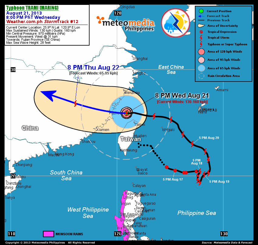
As of 8:00 pm today, the eye of Typhoon Trami (Maring) was located near the northern coast of Taiwan...about 120 km northwest of Taipei, Taiwan or 160 km east of Fuzhou, China...currently moving west with an increased forward speed of 31 km/hr towards Fujian Province (Southeastern China).
Maximum Sustained Winds (1-min. avg) have increased to 130 km/hr near the center with higher gusts. Typhoon Force Winds (118 km/hr or more) extend outward up to 45 kilometers from the center...and Tropical Storm Force Winds (63-100 km/hr) extend outward up to 185 kilometers. Trami (Maring) has grown into a very large-sized tropical cyclone with a diameter of 935 kilometers across. The 24-hour rainfall accumulation near the center of Trami (Maring) is estimated to be extreme (400 mm).
1-DAY FORECAST OUTLOOK*
Typhoon Trami (Maring) is expected to move generally westward during the next 12 hours...with a slight turn to the west-northwest thereafter. On the forecast track, the core of Trami (Maring) will make landfall over Fujian Province (Southeastern China) after or before midnight Thursday (approx 11pm to 1am)...passing over or very close to Fuzhou City. By Thursday evening, the typhoon will move over Jiangxi Province (Southeastern China).
Trami (Maring) will start to lose strength within the next 12 to 24 hours as it moves over land mass...weakening rapidly into a Tropical Storm (TS) on Thursday evening.
The following is the summary of the 1-day forecast outlook on this system:
 THURSDAY EVENING: Moving over Jiangxi Province...just a weak TS as it dissipates rapidly...about 330 km west-northwest of Fuzhou City, China [8PM AUG 22: 26.8N 116.1E @ 65kph].
*Please be reminded that the Forecast Outlook changes every 6 hours, and the Day 2 and 3 Forecast Tracks have an average error of 100 and 250 km respectively...while the wind speed forecast error, averages 35 kph per day. Therefore, a turn to the left or right of its future track and changes in its wind speed must be anticipated from time to time.
EFFECTS & HAZARDS SUMMARY
Below is the summary of the storm's parts and its hazards affecting specific areas. You can also view this image link for you to understand the parts.
CLOUD-FILLED + RAGGED EYE - Approaching the shores of Fujian Province. Possible calm and lull conditions (with <20 kph winds) will be expected inside the eye (click here to know more about the EYE). EYEWALL - where Typhoon Conditions with Typhoon Force Winds (>118 kph) will be expected within this wall. Affected Areas: Over the shores of Fujian Province (SE China) (click here to know more about the Eyewall). INNER RAINBANDS - where Tropical Storm Conditions with Tropical Storm Force Winds (63-117 kph) will be expected. Affected Areas: Fujian Province and Northern Taiwan. OUTER RAINBANDS - where Tropical Depression Conditions with light, moderate to strong winds (30-62 kph) will be expected. Affected Areas: Rest of Taiwan, Yaeyama and Miyako Islands, Fujian and Zhejiang Provinces (Southeastern China) (click here to know more about Rainbands). 24HR TOTAL RAINFALL ACCUMULATION - from 5 up to 200 mm (slight to heavy rainfall) can be expected along areas affected by the outer & inner rainbands (see above)...with isolated amounts of 201 to 400 mm (heavy to extreme) along areas to the south, west and near the center of Trami (Maring). COASTAL STORM SURGE FLOODING - possible 4-5 ft (1.2-1.7 m) above normal tide levels...accompanied by large and dangerous battering waves can be expected along the coastal, inland lakes and beach front areas of Northern Taiwan and Southeastern China tonight. Minimal damage is likely on this type of storm surge. Danger from Rip Currents or Rip Tides can be expected along the rest of the beach-front areas of Southern China, Rest of Taiwan, Yaeyama and Miyako Islands, and Extreme Northern Luzon (click here to know more about Storm Surge).
Important Note: Please keep in mind that the above forecast outlook, effects and hazards summary changes every 6 to 12 hrs!
CURRENT TECHNICAL INFORMATION
Time/Date: 8:00 PM PhT Wed Aug 21, 2013
Class/Name: TY Trami (Maring)
Location of Eye: 25.9º N Lat 120.9º E Lon
Distance 1: 120 km NW of Taipei, Taiwan
Distance 2: 160 km E of Fuzhou, China
Distance 3: 235 km S of Wenzhou, China
Distance 4: 315 km ENE of Xiamen, China
Distance 5: 610 km NNW of Basco, Batanes
MaxWinds (1-min avg): 130 kph near the center
Peak Wind Gusts: 160 kph
Saffir-Simpson Hurricane Scale: Category 1
Present Movement: West @ 31 kph
Towards: Fujian Province
CPA [ETA] to Fujian Province: Late Tonight [11PM-1AM PhT]
24hr Rainfall Accum (near center): Extreme [400 mm]
Minimum Central Pressure: 970 millibars (hPa)
Size (in Diameter): 935 km [Very Large]
Max Sea Wave Height (near center): 28 ft
Possible Storm Surge Height: 4-5 ft (1.2-1.7 m)
T2K/WP StormTracks (for Public): GIF | Google Map (Flash)
CURRENT TRACKING MAP:
 _____________________________________________________________________________
__________________________________________________________________________________________________
CURRENT NOAA/MTSAT-2 INFRARED (IR) SATELLITE IMAGE:

__________________________________________________________________________________________________
>> To know the meteorological terminologies and acronyms used on this update visit the ff:
http://typhoon2000.ph/tcterm.htm
http://www.nhc.noaa.gov/aboutgloss.shtml
http://www.nhc.noaa.gov/acronyms.shtml
__________________________________________________________________________________________
For the complete details on TY TRAMI (MARING)...go visit our website @:
> http://www.typhoon2000.com
> http://www.maybagyo.com
<<<Typhoon2000.com Mobile >>>
Get the latest SMS Storm Alerts!
For more details: Text T2K TYPHOON to
2800 (Globe/TM) | Offline (Smart/TNT) | 2288 (Sun)
*Only P2.50 (Smart/Globe) / P2.00 (Sun) per msg received.
Click here on how to use this service (in PDF file)
Powered by: Synermaxx Corporation
Copyright © 2013 Typhoon2000.com All Rights Reserved
| Reply via web post | Reply to sender | Reply to group | Start a New Topic | Messages in this topic (1) |

No comments:
Post a Comment