
for Thursday, 22 August 2013 [8:02 AM PhT]
WEATHER.COM.PH TROPICAL CYCLONE UPDATES
TYPHOON TRAMI (MARING) UPDATE NUMBER 013 [FINAL]
Issued: 6:00 AM PhT (22:00 GMT) Thursday 22 August 2013
Typhoon TRAMI (MARING) is now making landfall very near to the south of Fuzhou City in Fujian Province...Typhoon Conditions with threatening floods and landslides may be expected along Fujian Province this morning...extending across Jiangxi Province later today. Rapid dissipation of this cyclone will be expected within the next 24 to 48 hours due to land interaction and frictional effects.
This typhoon will continue to induce the Southwest Monsoon (Hanging Habagat) - bringing cloudy and windy conditions with "on-and-off" slight to moderate to sometimes heavy rains across the western sections of Luzon and Visayas...becoming more frequent along the coastal areas of Bataan, Zambales, Pangasinan, Ilocos Provinces and La Union today. Improving weather conditions will be expected beginning til Friday. Flash floods and landslides are likely in hazard-prone areas especially along river banks and mountain slopes.
Meanwhile, Tropical Storm (TS) PEWA (01C) continues to move slowly across the open seas of the Western Pacific Ocean. Latest dynamic forecast models continues to show the system intensifying as it moves generally northwestward during the next 3 days. Its center was located about 415 km northeast of Wake Island or 4,830 km east-northeast of the Philippines (21.5N Lat 169.9E Lon)...with maximum winds of 65 km/hr near the center...moving WNW @ 11 kph. This storm is too far away to affect any part of the Philippines.
*This is the last and final update on Trami (Maring).
Do not use this for life or death decisions. This update is intended for additional information purposes only. Kindly refer to your national weather agency for official warnings, advisories or bulletins.
CURRENT STORM ANALYSIS
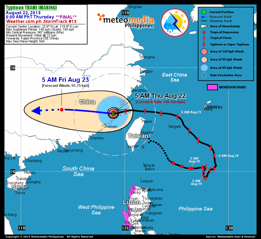
As of 5:00 am today, the eye of Typhoon Trami (Maring) was located near over Fujian Province, Southeastern China...about 70 km southwest of Fuzhou City, China or 145 km north-northeast of Xiamen City, China...currently moving west with a decreased forward speed of 22 km/hr towards Fujian and Jiangxi Provinces (Southeastern China).
Maximum Sustained Winds (1-min. avg) have increased to 140 km/hr near the center with higher gusts. Typhoon Force Winds (118 km/hr or more) extend outward up to 45 kilometers from the center...and Tropical Storm Force Winds (63-100 km/hr) extend outward up to 185 kilometers. Trami (Maring) remains a very large-sized tropical cyclone with a diameter of 935 kilometers across. The 24-hour rainfall accumulation near the center of Trami (Maring) is estimated to be heavy (300 mm).
1-DAY FORECAST OUTLOOK*
Typhoon Trami (Maring) is expected to move generally westward during the next 12 hours, with a slight west-southwest turn thereafter. On the forecast track, the core of Trami (Maring) will be traversing Fujian Province (Southeastern China) this morning...and will move across Jiangxi Province later this afternoon or evening. By Friday morning, it will be moving over the eastern part of Hunan Province (Southeastern China).
Trami (Maring) will start to rapidly weaken within the next 12 to 18 hours...decaying into a Tropical Depression (TD) on Friday morning. Complete dissipation of this cyclone will be expected on Saturday.
The following is the summary of the 1-day forecast outlook on this system:
 FRIDAY MORNING: Moving over Hunan Province...just a TD as it dissipates rapidly over land...about 410 km north of Hong Kong, China [5AM AUG 23: 26.0N 113.9E @ 65kph].
*Please be reminded that the Forecast Outlook changes every 6 hours, and the Day 2 and 3 Forecast Tracks have an average error of 100 and 250 km respectively...while the wind speed forecast error, averages 35 kph per day. Therefore, a turn to the left or right of its future track and changes in its wind speed must be anticipated from time to time.
EFFECTS & HAZARDS SUMMARY
Below is the summary of the storm's parts and its hazards affecting specific areas. You can also view this image link for you to understand the parts.
CLOUD-FILLED + RAGGED EYE - Over the eastern part of Fujian Province, just south of Fuzhou City. Possible calm and lull conditions (with <20 kph winds) will be expected inside the eye (click here to know more about the EYE). EYEWALL - where Typhoon Conditions with Typhoon Force Winds (>118 kph) will be expected within this wall. Affected Areas: Over the eastern part Fujian Province (SE China) which includes the city of Fuzhou (click here to know more about the Eyewall). INNER RAINBANDS - where Tropical Storm Conditions with Tropical Storm Force Winds (63-117 kph) will be expected. Affected Areas: The rest of Fujian Province. OUTER RAINBANDS - where Tropical Depression Conditions with light, moderate to strong winds (30-62 kph) will be expected. Affected Areas: Rest of Taiwan and Southeastern China including the eastern part of Guangdong Province (click here to know more about Rainbands). 24HR TOTAL RAINFALL ACCUMULATION - from 5 up to 200 mm (slight to heavy rainfall) can be expected along areas affected by the outer & inner rainbands (see above)...with isolated amounts of 201 to 300 mm (heavy) along areas to the south, west and near the center of Trami (Maring).
Important Note: Please keep in mind that the above forecast outlook, effects and hazards summary changes every 6 to 12 hrs!
CURRENT TECHNICAL INFORMATION
Time/Date: 5:00 AM PhT Thu Aug 22, 2013
Class/Name: TY Trami (Maring)
Location of Eye: 25.6º N Lat 118.9º E Lon
Distance 1: 70 km SW of Fuzhou, China
Distance 2: 145 km NNE of Xiamen, China
Distance 3: 280 km WNW of Taipei, Taiwan
Distance 4: 650 km NNW of Basco, Batanes
MaxWinds (1-min avg): 140 kph near the center
Peak Wind Gusts: 165 kph
Saffir-Simpson Hurricane Scale: Category 1
Present Movement: West @ 22 kph
Towards: Fujian and Jiangxi Provinces
24hr Rainfall Accum (near center): Heavy [300 mm]
Minimum Central Pressure: 967 millibars (hPa)
Size (in Diameter): 935 km [Very Large]
Max Sea Wave Height (near center): N/A (Overland)
T2K/WP StormTracks (for Public): GIF | Google Map (Flash)
CURRENT TRACKING MAP:
 _____________________________________________________________________________
__________________________________________________________________________________________________
CURRENT NOAA/MTSAT-2 INFRARED (IR) SATELLITE IMAGE:

__________________________________________________________________________________________________
>> To know the meteorological terminologies and acronyms used on this update visit the ff:
http://typhoon2000.ph/tcterm.htm
http://www.nhc.noaa.gov/aboutgloss.shtml
http://www.nhc.noaa.gov/acronyms.shtml
__________________________________________________________________________________________
For the complete details on TY TRAMI (MARING)...go visit our website @:
> http://www.typhoon2000.com
> http://www.maybagyo.com
<<<Typhoon2000.com Mobile >>>
Get the latest SMS Storm Alerts!
For more details: Text T2K TYPHOON to
2800 (Globe/TM) | Offline (Smart/TNT) | 2288 (Sun)
*Only P2.50 (Smart/Globe) / P2.00 (Sun) per msg received.
Click here on how to use this service (in PDF file)
Powered by: Synermaxx Corporation
Copyright © 2013 Typhoon2000.com All Rights Reserved
| Reply via web post | Reply to sender | Reply to group | Start a New Topic | Messages in this topic (1) |

No comments:
Post a Comment