
for Saturday, 10 August 2013 [6:54 AM PhT]
WEATHER.COM.PH TROPICAL CYCLONE UPDATES
TROPICAL STORM UTOR (LABUYO) UPDATE NUMBER 003
Issued: 6:00 AM PhT (22:00 GMT) Saturday 10 August 2013
Next Update: 12:00 NN PhT (04:00 GMT) Saturday 10 August 2013
11W (LABUYO) has rapidly gained strength into a Tropical Storm (TS) while over the Philippine Sea...and is now internationally known as UTOR...threatens Central and Northern Luzon.
Residents and visitors along Luzon including Batanes Group of Islands and Taiwan should closely monitor the development of Utor (Labuyo).
Do not use this for life or death decisions. This update is intended for additional information purposes only. Kindly refer to your national weather agency for official warnings, advisories or bulletins.
CURRENT STORM ANALYSIS
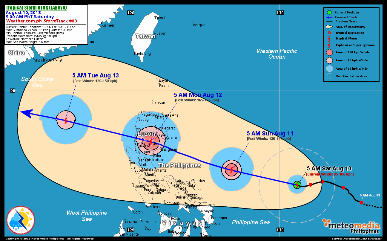
As of 5:00 am today, the center of TS Utor (Labuyo) was located over the the Philippine Sea...about 725 km east-northeast of Catarman, Northern Samar or 755 km east of Virac, Catanduanes...currently moving west-northwest with a decreased forward speed of 19 km/hr in the general direction of Northern Luzon.
Maximum Sustained Winds (1-min. avg) have rapidly increased to near 85 km/hr near the center with higher gusts. Tropical Storm Force Winds (63-100 km/hr) extend outward up to 75 kilometers from the center. Utor (Labuyo) is an average-sized tropical cyclone with a diameter of 370 kilometers across. The 24-hour rainfall accumulation near the center of Utor (Labuyo) is estimated to be heavy (250 mm).
2-DAY FORECAST OUTLOOK*
TS Utor (Labuyo) is expected to continue moving generally west-northwestward throughout the forecast period. On the forecast track, the core of Utor (Labuyo) will be passing well to the north of Bicol Region on Sunday afternoon...approaching the eastern shoreline of Aurora and Isabela by Sunday evening...and will cut across Northern Luzon via Northern Aurora-Quirino-Nueva Vizcaya-Benguet-La Union beginning midnight until noon on Monday.
Utor (Labuyo) is expected to continue to strengthen within the next 24 to 48 hours...becoming a Typhoon on Sunday morning. Advance Intensity Forecast (AIF) shows the potential Typhoon reaching peak winds of more than 165 km/hr on Sunday evening - before it makes landfall over Northern Aurora.
The following is the summary of the 2-day forecast outlook and an extended 3-day forecast on this system:
 SUNDAY MORNING: Becomes a Typhoon as it moves across the Philippine Sea...about 290 km east-northeast of Pandan, Catanduanes [5AM AUGUST 11: 14.7N 126.8E @ 130kph].
MONDAY MORNING: Crossing Northern Luzon or over the northern part of Nueva Vizcaya...about 45 km southwest of Cauayan, Isabela [5AM AUGUST 12: 16.6N 121.4E @ 165kph].
TUESDAY MORNING: Moving across the West Philippine & South China Seas, exits PAR as it weakens slightly...about 490 km south-southeast of Hong Kong, China [5AM AUGUST 13: 18.0N 115.7E @ 120kph].
*Please be reminded that the Forecast Outlook changes every 6 hours, and the Day 2 and 3 Forecast Tracks have an average error of 100 and 250 km respectively...while the wind speed forecast error, averages 35 kph per day. Therefore, a turn to the left or right of its future track and changes in its wind speed must be anticipated from time to time.
EFFECTS & HAZARDS SUMMARY
Below is the summary of the storm's parts and its hazards affecting specific areas. You can also view this image link for you to understand the parts.
INNER RAINBANDS - where Tropical Storm Conditions with Tropical Storm Force Winds (63-100 kph) will be expected. Affected Areas: None (still over Philippine Sea). OUTER RAINBANDS - where Tropical Depression Conditions with light, moderate to strong winds (30-62 kph) will be expected. Affected Areas: None (still over Philippine Sea). (click here to know more about Rainbands) 24HR TOTAL RAINFALL ACCUMULATION - from 5 up to 100 mm (slight to heavy rainfall) can be expected along areas affected by the outer & inner rainbands (see above)...with isolated amounts of 101 to 250 mm (heavy) along areas near the center of Utor (Labuyo).
Important Note: Please keep in mind that the above forecast outlook, effects and hazards summary changes every 6 to 12 hrs!
CURRENT TECHNICAL INFORMATION
Time/Date: 5:00 AM PhT Sat Aug 10, 2013
Class/Name: TS Utor (Labuyo)
Location of Center: 13.7º N Lat 131.2º E Lon
Distance 1: 725 km ENE of Catarman, Northern Samar
Distance 2: 755 km E of Virac, Catanduanes
Distance 3: 800 km E of Caramoan, CamSur
Distance 4: 815 km ENE of Legazpi City
Distance 5: 865 km E of Metro Naga
Distance 6: 895 km ESE of Daet, CamNorte
Distance 7: 1010 km ESE of Polillo Island
Distance 8: 1015 km SE of Casiguran, Aurora
MaxWinds (1-min avg):85 kph near the center
Peak Wind Gusts: 100 kph
Present Movement: WNW @ 19 kph
Towards: Northern Luzon
24hr Rainfall Accum (near center): Heavy [250 mm]
Minimum Central Pressure: 989 millibars (hPa)
Size (in Diameter): 370 km [Average]
Max Sea Wave Height (near center): 16 feet
Possible Storm Surge Height: 1-3 ft (0.3-0.9 m)
T2K/WP StormTracks (for Public): GIF | Google Map (Flash)
CURRENT TRACKING MAP:
 _____________________________________________________________________________
__________________________________________________________________________________________________
CURRENT NOAA/MTSAT-2 INFRARED (IR) SATELLITE IMAGE:

__________________________________________________________________________________________________
>> To know the meteorological terminologies and acronyms used on this update visit the ff:
http://typhoon2000.ph/tcterm.htm
http://www.nhc.noaa.gov/aboutgloss.shtml
http://www.nhc.noaa.gov/acronyms.shtml
__________________________________________________________________________________________
For the complete details on TS UTOR (LABUYO)...go visit our website @:
> http://www.typhoon2000.com
> http://www.maybagyo.com
<<<Typhoon2000.com Mobile >>>
Get the latest SMS Storm Alerts!
For more details: Text T2K TYPHOON to
2800 (Globe/TM) | Offline (Smart/TNT) | 2288 (Sun)
*Only P2.50 (Smart/Globe) / P2.00 (Sun) per msg received.
Click here on how to use this service (in PDF file)
Powered by: Synermaxx Corporation
Copyright © 2013 Typhoon2000.com All Rights Reserved
| Reply via web post | Reply to sender | Reply to group | Start a New Topic | Messages in this topic (1) |

No comments:
Post a Comment