
WEATHER.COM.PH TROPICAL CYCLONE UPDATES
TROPICAL STORM SOULIK (HUANING) UPDATE NUMBER 017 [FINAL]
Issued: 7:00 AM PhT (23:00 GMT) Sunday 14 July 2013
SOULIK (HUANING) rapidly losing intensity and organization...just a weak Tropical Storm as it moves rapidly over Jiangxi Province, China. Complete dissipation of this system expected within the next 12 to 24 hours.
*This is the last and final update on Soulik (Huaning).
Do not use this for life or death decisions. This update is intended for additional information purposes only. Kindly refer to your national weather agency for official warnings, advisories or bulletins.
CURRENT STORM ANALYSIS
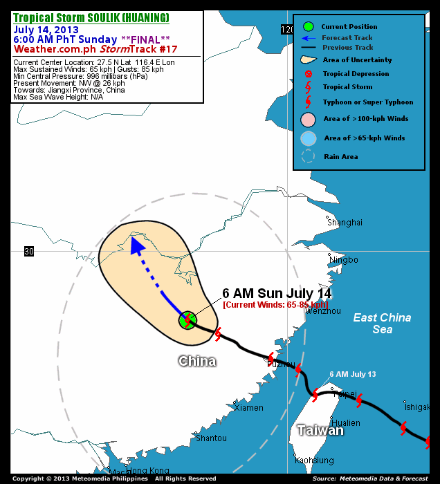
As of 6:00 am today, the center of TS Soulik (Huaning) was last located over the eastern portion of Jiangxi Province...about 320 km northwest of Fuzhou City, China or 625 km north of Hong Kong...currently moving northwest with an accelerated forward speed of 26 km/hr in the general direction of Central Jiangxi Province.
Maximum Sustained Winds (1-min. avg) have rapidly decreased to near 65 km/hr near the center with higher gusts. . Soulik (Huaning) is an average-sized tropical cyclone with a diameter of 555 kilometers across. The 24-hour rainfall accumulation near the center of Soulik (Huaning) is estimated to be heavy (300 mm).
EFFECTS & HAZARDS SUMMARY
Below is the summary of the storm's parts and its hazards affecting specific areas. You can also view this image link for you to understand the parts.
 DECAYING RAINBANDS - where Tropical Depression Conditions with light, moderate to strong winds (30-62 kph) will be expected. Affected Areas: The Chinese provinces of Jiangxi, Eastern Guangdong, and Fujian. (click here to know more about Rainbands) 24HR TOTAL RAINFALL ACCUMULATION - from 5 up to 100 mm (slight to heavy rainfall) can be expected along areas affected by the outer & inner rainbands (see above)...with isolated amounts of 101 to 300 mm (heavy) along areas near the center of Soulik (Huaning).
Important Note: Please keep in mind that the above forecast outlook, effects and hazards summary changes every 6 to 12 hrs!
CURRENT TECHNICAL INFORMATION
Time/Date: 6:00 AM PhT Sun July 14, 2013
Class/Name: TS Soulik (Huaning)
Location of Center: 27.5º N Lat 116.4º E Lon
Distance 1: 320 km NW of Fuzhou, China
Distance 2: 405 km WSW of Wenzhou, China
Distance 3: 625 km NNE of Hong Kong
Distance 4: 630 km SW of Shanghai, China
MaxWinds (1-min avg): 65 kph near the center
Peak Wind Gusts: 85 kph
Present Movement: NW @ 26 kph
Towards: Central Jiangxi (China)
24hr Rainfall Accum (near center): Heavy [300 mm]
Minimum Central Pressure: 996 millibars (hPa)
Size (in Diameter): 555 km [Average]
Max Sea Wave Height (near center): N/A
Possible Storm Surge Height: 0 ft (0 m)
T2K/WP StormTracks (for Public): GIF | Google Map (Flash)

__________________________________________________________________________________________________
CURRENT NOAA/MTSAT-2 INFRARED (IR) SATELLITE IMAGE:

CURRENT TRACKING MAP:
 _____________________________________________________________________________
>> To know the meteorological terminologies and acronyms used on this update visit the ff:
http://typhoon2000.ph/tcterm.htm
http://www.nhc.noaa.gov/aboutgloss.shtml
http://www.nhc.noaa.gov/acronyms.shtml
__________________________________________________________________________________________
For the complete final details on TS SOULIK (HUANING)...go visit our website @:
> http://www.typhoon2000.com
> http://www.maybagyo.com
<<<Typhoon2000.com Mobile >>>
Get the latest SMS Storm Alerts!
For more details: Text T2K TYPHOON to
2800 (Globe/TM) | Offline (Smart/TNT) | 2288 (Sun)
*Only P2.50 (Smart/Globe) / P2.00 (Sun) per msg received.
Click here on how to use this service (in PDF file)
Powered by: Synermaxx Corporation
Copyright © 2013 Typhoon2000.com All Rights Reserved
| Reply via web post | Reply to sender | Reply to group | Start a New Topic | Messages in this topic (1) |

No comments:
Post a Comment