
WEATHER.COM.PH TROPICAL CYCLONE UPDATES
TROPICAL STORM LEEPI (EMONG) UPDATE NUMBER 009
Issued: 7:00 PM PhT (11:00 GMT) Thursday 20 June 2013
Next Update: 7:00 AM PhT (23:00 GMT) Friday 21 June 2013
Tropical Storm LEEPI [EMONG] rapidly moving fast across the East China Sea...expected to turn to the northeast later tonight or Friday...threatens Kyushu, Japan.
Residents and visitors along Western Japan should closely monitor the development of LEEPI (EMONG).
Do not use this for life or death decision. This update is intended for additional information purposes only. Kindly refer to your national weather agency for official warnings, advisories or bulletins.
CURRENT STORM ANALYSIS
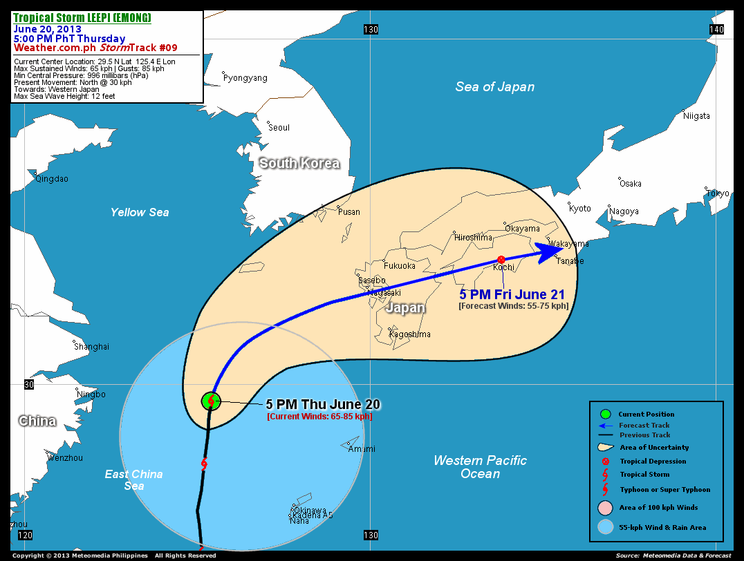
As of 5:00 pm today, the center of TS Leepi (Emong) was located over the East China Sea...about 408 km southeast of Okinawa, Japan or 540 km west-southwest of Kagoshima, Japan...currently moving north with an increased forward speed of 30 km/hr in the general direction of Kyushu.
Maximum Sustained Winds (1-min. avg) remained at 65 km/hr near the center with higher gusts. Leepi (Emong) is a large-sized tropical cyclone with a diameter of 795 kilometers across. The 24-hour rainfall accumulation near the center of Leepi (Emong) is estimated to be heavy (200 mm).
1-DAY FORECAST OUTLOOK*
TS Leepi (Emong) is expected to move northeast to east-northeast within the next 12 to 24 hours. On the forecast track, the core of Leepi (Emong) will make landfall over Western Kyushu...near the city of Nagasaki tomorrow morning...and will start to dissipate tomorrow afternoon while passing very near Kochi City in Shikoku, Japan.
Leepi (Emong) is forecast to maintain its strength during the next 12 hours...and will start to weaken into a Tropical Depression (TD) tomorrow afternoon.
The following is the summary of the 1-day forecast outlook on this system:
 SATURDAY AFTERNOON: Just a TD as it moves across Shikoku, Japan...about 19 km east of Kochi, Japan [5PM JUNE 21: 33.6N 133.8E @ 55kph].
*Please be reminded that the Forecast Outlook changes every 6 hours, and the Day 3 Forecast Track have an average error of 250 km...while the wind speed forecast error, averages 35 kph per day. Therefore, a turn to the left or right of its future track and changes in its wind speed must be anticipated from time to time.
EFFECTS & HAZARDS SUMMARY
Below is the summary of the storm's parts and its hazards affecting specific areas. You can also view this image link for you to understand the parts.
INNER RAINBANDS - spreading over the East China Sea. Affected Areas: None. Tropical Storm Conditions with Tropical Storm Force Winds (63-85 kph) will be expected along these bands. OUTER RAINBANDS - spreading across the North Philippine Sea & Western Pacific Ocean. Affected Areas: Eastern Taiwan, Okinawa and Ryukyu Islands. Tropical Depression Conditions with light, moderate to strong winds (30-62 kph) will be expected along these bands (click here to know more about Rainbands). 24HR TOTAL RAINFALL ACCUMULATION - from 5 up to 100 mm (slight to heavy rainfall) can be expected along areas affected by the outer & inner rainbands (see above)...with isolated amounts of 101 to 200 mm (heavy) along areas to the north and south, and near the center of Leepi (Emong).
Important Note: Please keep in mind that the above forecast outlook, effects and hazards summary changes every 6 to 12 hrs!
CURRENT TECHNICAL INFORMATION
Time/Date: 5:00 PM PhT Thu June 20, 2013
Class/Name: TS Leepi (Emong)
Location of Center: 29.5º N Lat 125.4º E Lon
Distance 1: 379 km ESE of Ningbo, China
Distance 2: 408 km NW of Okinawa, Japan
Distance 3: 419 km SE of Shanghai, China
Distance 4: 540 km WSW of Kagoshima, Japan
MaxWinds (1-min avg): 65 kph near the center
Peak Wind Gusts: 85 kph
Present Movement: North @ 30 kph
Towards: Kyushu
24hr Rainfall Accum (near center): Heavy [200 mm]
Minimum Central Pressure: 996 millibars (hPa)
Size (in Diameter): 795 km [Large]
Max Sea Wave Height (near center): 12 feet
Possible Storm Surge Height: 0 ft (0 m)
T2K/WP StormTracks (for Public): GIF | Google Map (Flash)

CURRENT NOAA/MTSAT-2 INFRARED (IR) SATELLITE IMAGE:

CURRENT TRACKING MAP:
 _____________________________________________________________________________
>> To know the meteorological terminologies and acronyms used on this update visit the ff:
http://typhoon2000.ph/tcterm.htm
http://www.nhc.noaa.gov/aboutgloss.shtml
http://www.nhc.noaa.gov/acronyms.shtml
__________________________________________________________________________________________
For the complete details on TS LEEPI (EMONG)...go visit our website @:
> http://www.typhoon2000.com
> http://www.maybagyo.com
<<<Typhoon2000.com Mobile >>>
Get the latest SMS Storm Alerts!
For more details: Text T2K TYPHOON to
2800 (Globe/TM) | Offline (Smart/TNT) | 2288 (Sun)
*Only P2.50 (Smart/Globe) / P2.00 (Sun) per msg received.
Click here on how to use this service (in PDF file)
Powered by: Synermaxx Corporation
Copyright © 2013 Typhoon2000.com All Rights Reserved
| Reply via web post | Reply to sender | Reply to group | Start a New Topic | Messages in this topic (1) |

No comments:
Post a Comment