
WEATHER.COM.PH TROPICAL CYCLONE UPDATES
TROPICAL DEPRESSION 02W (CRISING) UPDATE NUMBER 001
Issued: 1:00 PM PhT (05:00 GMT) Tuesday 19 Feb 2013
Next Update: 7:00 PM PhT (11:00 GMT) Tuesday 19 Feb 2013
The strong disturbance (LPA) off the coast of Davao Del Sur and South Cotabato has accelerated and reorganized over the Moro Gulf...now strengthened into Tropical Depression 02W (Crising). Broad rainbands continues to affect much of Mindanao, Central & Southern Visayas - bringing occasionally moderate to heavy rains w/ high threat of flashfloods and landslides.
This depression will continue to enhance the Northeast Monsoon (Hanging Amihan) and bring cloudy skies w/ 15-55 km/hr winds across Luzon including Metro Manila, Mindoro, Marinduque and the Bicol Region today. Some possible drizzles to slight rains will be expected along Catanduanes, Camarines Sur, Albay, Sorsogon, Masbate, Mindoro and Northern Visayas.
Do not use this for life or death decision. This update is intended for additional information purposes only. Kindly refer to your national weather agency for official warnings, advisories or bulletins.
CURRENT STORM ANALYSIS
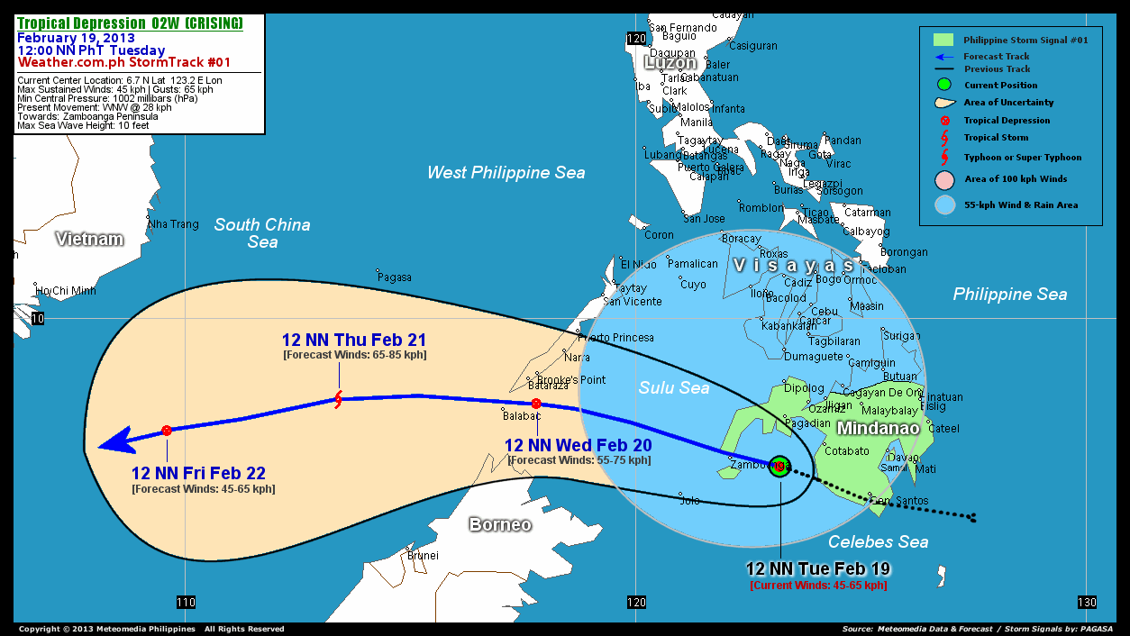
As of 12 NN today, the center of Tropical Depression 02W (Crising) was located over the Moro Gulf...about 124 km east-southeast of Zamboanga City or 123 km south of Pagadian City...currently moving west-northwest with an increased forward speed of 28 km/hr in the general direction of the Zamboanga Peninsula.
Maximum Sustained Winds (1-min. avg) are at 45 km/hr near the center with higher gusts. A number of WeatherPhilippines/Meteomedia Automated Weather Stations (AWS) across Mindanao has registered more than 50 millimeters (mm) of rainfall in a span of 24 hours, which is considered moderate to heavy. The 24-hour rainfall accumulation near the center of 02W (Crising) is estimated to be heavy (200 mm).
3-DAY FORECAST OUTLOOK*
TD 02W (Crising) is expected to move west-northwest during the next 24 hours, with a turn to the west and west-southwest through the next 2 to 3 days. On the forecast track, the core of 02W (Crising) will continue to move across the warm waters of the Moro Gulf this afternoon and traverse the Zamboanga Peninsula later tonight. On Wednesday, the depression will traverse the Sulu Sea in the morning...and pass over the Southern tip of Palawan in the afternoon. By Thursday afternoon, 02W (Crising) should be out of the Philippine Area of Responsibility (PAR) as it traverse the West Philippine Sea. It should be moving across the South China Sea on Friday.
02W (Crising) is forecast to slowly intensify through the next 2 days...and could become a minimal Tropical Storm on Thursday...and weaken back to a Tropical Depression on Friday.
The following is the summary of the 3-day forecast outlook on this system:
 WEDNESDAY NOON: Passing over the southern tip of Palawan, strengthens slightly...about 78 km south of Brooke's Point, Palawan [12PM FEB 20: 8.1N 117.8E @ 55kph].
THURSDAY NOON: Upgraded to a Tropical Storm as it moves out of the PAR...about 397 km west of Balabac, Palawan [12PM FEB 21: 8.2N 113.4E @ 65kph].
FRIDAY NOON: Downgraded to a Tropical Depression as it turns west-southwest across the South China Sea...about 486 km southeast of Ho Chi Minh City, Vietnam [12PM FEB 22: 7.5N 109.6E @ 45kph].
*Please be reminded that the Forecast Outlook changes every 6 hours, and the Day 3 Forecast Track have an average error of 250 km...while the wind speed forecast error, averages 35 kph per day. Therefore, a turn to the left or right of its future track and changes in its wind speed must be anticipated from time to time.
EFFECTS & HAZARDS SUMMARY
Below is the summary of the storm's parts and its hazards affecting specific areas. You can also view this image link for you to understand the parts.
RAINBANDS - spreading across Southern Philippines, Moro Gulf, & Sulu Sea. Affected Areas: Mindanao, Central & Southern Visayas. Tropical Disturbance Conditions with light, moderate to strong winds (05-55 kph) will be expected along these bands (click here to know more about Rainbands). 24HR TOTAL RAINFALL ACCUMULATION - from 5 up to 100 mm (slight to heavy rainfall) can be expected along areas affected by the rainbands (see above)...with isolated amounts of 101 to 200 mm (heavy) along areas near the center of 02W (Crising).
Important Note: Please keep in mind that the above forecast outlook, effects and hazards summary changes every 6 to 12 hrs!
CURRENT TECHNICAL INFORMATION
Time/Date: 12:00 NN PhT Tue February 19, 2013
Class/Name: TD 02W (Crising)
Location of Center: 6.7º N Lat 123.2º E Lon
Distance 1: 123 km South of Pagadian City
Distance 2: 124 km ESE of Zamboanga City
Distance 3: 124 km SW of Cotabato City
Distance 4: 212 km South of Dipolog City
Distance 5: 231 km WNW of General Santos City
Distance 6: 252 km ENE of Jolo, Sulu
MaxWinds (1-min avg): 45 kph near the center
Peak Wind Gusts: 65 kph
Present Movement: WNW @ 28 kph
Towards: Zamboanga Peninsula
24hr Rainfall Accum (near center): Heavy [200 mm]
Minimum Central Pressure: 1002 millibars (hPa)
Max Sea Wave Height (near center): 10 feet
Possible Storm Surge Height: 0 ft (0 m)
T2K/WP StormTracks (for Public): GIF | Google Map (Flash)

CURRENT NOAA/MTSAT-2 INFRARED SATELLITE IMAGE:

CURRENT TRACKING CHART:
_____________________________________________________________________________
>> To know the meteorological terminologies and acronyms used on this update visit the ff:
http://typhoon2000.ph/tcterm.htm
http://www.nhc.noaa.gov/aboutgloss.shtml
http://www.nhc.noaa.gov/acronyms.shtml
__________________________________________________________________________________________
For the complete details on TD 02W (CRISING)...go visit our website @:
> http://www.typhoon2000.com
> http://www.maybagyo.com
<<<Typhoon2000.com Mobile >>>
Get the latest SMS Storm Alerts!
For more details: Text T2K TYPHOON to
2800 (Globe/TM) | 216 (Smart/TNT) | 2288 (Sun)
*Only P2.50 (Smart/Globe) / P2.00 (Sun) per msg received.
Click here on how to use this service (in PDF file)
Powered by: Synermaxx Corporation
Copyright © 2012 Typhoon2000.com All Rights Reserved
| Reply via web post | Reply to sender | Reply to group | Start a New Topic | Messages in this topic (1) |

No comments:
Post a Comment