
WEATHER.COM.PH / T2K TROPICAL CYCLONE UPDATES
TROPICAL STORM WUKONG (QUINTA) UPDATE NUMBER 006
Issued: 1:00 PM PhT (05:00 GMT) Wednesday 26 Dec 2012
Next Update: 7:00 PM PhT (23:00 GMT) Wednesday 26 Dec 2012
Tropical Storm Wukong (Quinta) continues to move quickly across Northwestern Visayas...now over the Northern Coast of Aklan and fast approaching Boracay Island.
Wukong (Quinta) will continue to enhance the Northeast Monsoon (Amihan) and bring moderate to strong winds with "on-and-off" rains across Eastern & Southern Luzon including Metro Manila today.
Residents and visitors along Southwestern Luzon and the Visayas including Northern Palawan should closely monitor the development of Wukong (Quinta).
Do not use this for life or death decision. This update is intended for additional information purposes only. Kindly refer to your national weather agency for official warnings, advisories or bulletins.
CURRENT STORM ANALYSIS
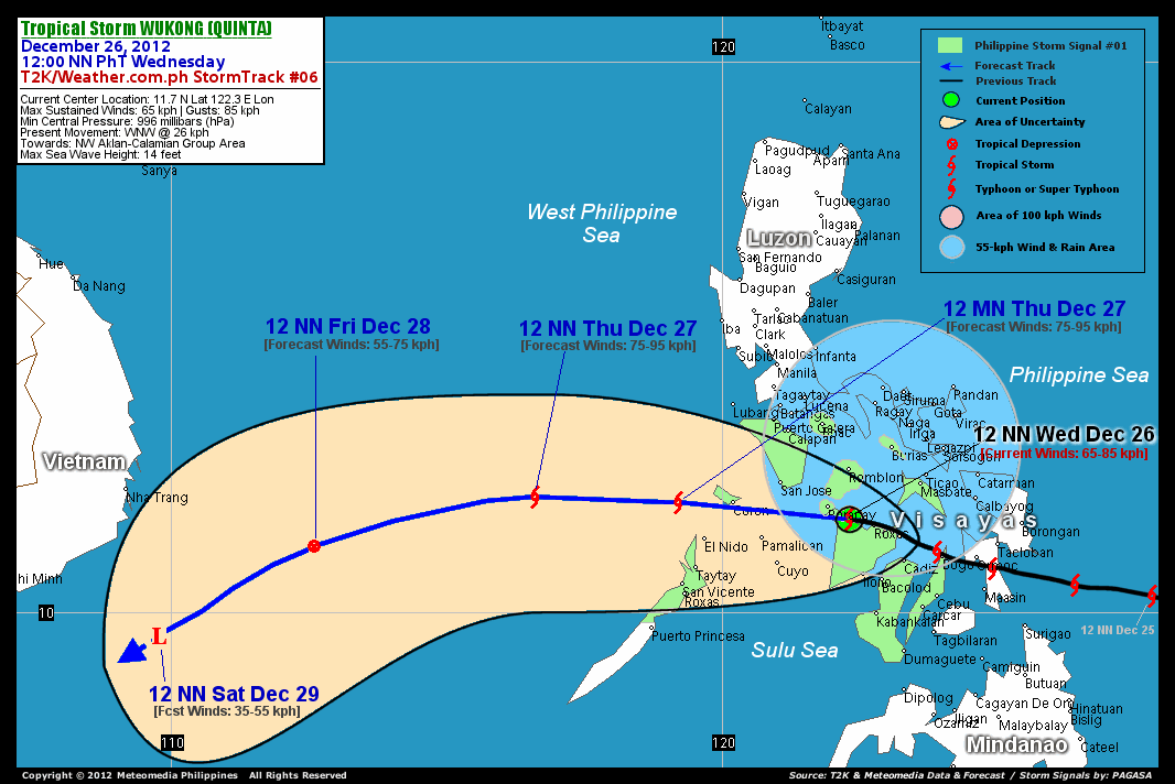
As of 12 noon today, the center of Tropical Storm Wukong (Quinta) was located over the northern shores of Aklan...about 49 km southeast of Boracay Island or 56 km west-northwest of Roxas City...currently moving west-northwest with a forward speed of 26 km/hr in the general direction of Northwestern Aklan and Calamian Group of Islands.
Maximum Sustained Winds (1-min. avg) remain at 65 km/hr near the center with higher gusts. Tropical Storm Force Winds (62-117 km/hr) extend outward up to 30 kilometers from the center Wukong (Quinta) is an average-sized tropical cyclone with a diameter of 445 kilometers across. The 24-hour rainfall accumulation near and to north of the center of TS Wukong (Quinta) is estimated to be heavy (210 mm).
3-DAY FORECAST OUTLOOK*
Tropical Storm Wukong (Quinta) is expected to move westward during the next 12 to 24 hours...with a turn to the west-southwest through 36 to 72 hours. On the forecast track, the core of Wukong (Quinta) is expected to emerge over the Sulu Sea after passing very close to Boracay Island this afternoon...and should be passing over the Calamian Group of Islands later tonight. This storm should be over the West Philippine Sea on Thursday noon and move out of the Philippine Area of Responsibility (PAR) by Friday early morning. On Saturday noon, Wukong (Quinta) should be moving across the sea, east of Southern Vietnam.
WUKONG (Quinta) is forecast to slightly re-intensify during the next 12 to 24 hours as it moves into the warm waters of the Sulu and West Philippine Seas later this evening until Thursday.
The following is the summary of the 3-day forecast outlook on this system:
 THURSDAY NOON: Gains strength as it moves over the West Philippine Sea...about 392 km west of Coron, Palawan [12PM DEC 27: 12.1N 116.6E @ 75kph].
FRIDAY NOON: Exits the Philippine Area of Responsibility (PAR)...downgraded to a Tropical Depression (TD)...about 386 km east-southeast of Nha Trang, Vietnam [12PM DEC 28: 11.2N 112.6E @ 55kph].
SATURDAY NOON: Turns west-southwestward while over the South China Sea...dissipated into an area of low pressure...about 307 km south-southeast of Nha Trang, Vietnam [12PM DEC 29: 9.6N 109.8E @ 35kph].
*Please be reminded that the Forecast Outlook changes every 6 hours, and the Day 3 Forecast Track have an average error of 250 km...while the wind speed forecast error, averages 35 kph per day. Therefore, a turn to the left or right of its future track and changes in its wind speed must be anticipated from time to time.
EFFECTS & HAZARDS SUMMARY
Below is the summary of the storm's parts and its hazards affecting specific areas. You can also view this image link for you to understand the parts.
INNER RAINBANDS - affecting and spreading across Panay Island, Boracay, Mindoro Oriental, and Romblon-Tablas Islands. Tropical Storm Conditions with Tropical Storm Force Winds (62-85 kph) will be expected along these bands. OUTER RAINBANDS - affecting and spreading across Bicol Region including Masbate, Ticao-Burias Islands, Negros, Calamian Group, Samar, Leyte, Marinduque, Mindoro Occidental, and Southern Quezon. Tropical Depression Conditions with moderate to strong winds (<62 kph) will be expected along these bands (click here to know more about Rainbands). 24HR TOTAL RAINFALL ACCUMULATION - from 5 up to 100 mm (slight to heavy rainfall) can be expected along areas affected by the outer & inner rainbands (see above)...with isolated amounts of 101 to 210 mm (heavy) along areas near and north of the center of Wukong (Quinta).
Important Note: Please keep in mind that the above forecast outlook, effects and hazards summary changes every 6 to 12 hrs!
CURRENT TECHNICAL INFORMATION
Time/Date: 12:00 NN PhT Wed December 26, 2012
Class/Name: TS Wukong (Quinta)
Location of Center: 11.7º N Lat 122.3º E Lon
Distance 1: 49 km (SE) from Boracay
Distance 2: 56 km (WNW) away from Roxas City
Distance 3: 100 km (S) from Romblon
Distance 4: 116 km (NNW) away from Iloilo City
Distance 5: 139 km (NNW) away from Bacolod City
Distance 6: 141 km (NW) away from Cadiz City
Distance 7: 152 km (SE) from San Jose, Mindoro Occ.
Distance 8: 161 km (SW) away from Masbate City
Distance 9: 177 km (ENE) from Amanpulo, Pamalican Is.
Distance 10: 231 km (ESE) from Coron, Palawan
Distance 11: 233 km (SSW) from Metro Naga
MaxWinds (1-min avg): 65 kph near the center
Peak Wind Gusts: 85 kph
Present Movement: WNW @ 26 kph
Towards: NW Aklan and Calamian Group
CPA [ETA] to Calamian Group: Tonight [8-10PM PhT]
24hr Rainfall Accum (near center): Heavy [210 mm]
Minimum Central Pressure: 996 millibars (hPa)
Size (in Diameter): 445 km [Average]
Max Sea Wave Height (near center): 14 feet
Possible Storm Surge Height: 1-3 ft (0.3-0.9 m)
T2K/WP StormTracks (for Public): GIF | Google Map (Flash)

CURRENT NOAA/MTSAT-2 INFRARED SATELLITE IMAGE:

CURRENT TRACKING CHART:
_____________________________________________________________________________
>> To know the meteorological terminologies and acronyms used on this update visit the ff:
http://typhoon2000.ph/tcterm.htm
http://www.nhc.noaa.gov/aboutgloss.shtml
http://www.nhc.noaa.gov/acronyms.shtml
__________________________________________________________________________________________
For the complete details on TS WUKONG (QUINTA)...go visit our website @:
> http://www.typhoon2000.com
> http://www.maybagyo.com
<<<Typhoon2000.com Mobile >>>
Get the latest SMS Storm Alerts!
For more details: Text T2K TYPHOON to
2800 (Globe/TM) | 216 (Smart/TNT) | 2288 (Sun)
*Only P2.50 (Smart/Globe) / P2.00 (Sun) per msg received.
Click here on how to use this service (in PDF file)
Powered by: Synermaxx Corporation
Copyright © 2012 Typhoon2000.com All Rights Reserved
| Reply via web post | Reply to sender | Reply to group | Start a New Topic | Messages in this topic (1) |

No comments:
Post a Comment