
Typhoon2000 (T2K) NEWS (Monday August 20, 2012):
Currently issuing 6-hrly web, SMS, email, & iTyphoon app updates (except 12 Midnight) on TEMBIN (IGME).
TEMBIN MAX WIND SPEED PER AGENCY:
+ USA (JTWC/1-min avg): 150 km/hr
+ Japan (JMA/10-min avg): 140 km/hr
+ Philippines (PAGASA/10-min avg): 140 km/hr
+ Beijing (NMC/2-min avg): 120 km/hr
+ Taiwan (CWB/10-min avg): 125 km/hr
+ Korea (KMA/10-min avg): 140 km/hr
+ Hong Kong (HKO/10-min avg): 130 km/hr
:: Click here to see Multi-Agency Forecast Tracks
TYPHOON2000 (T2K) TROPICAL CYCLONE UPDATES
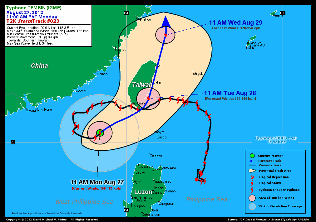
TYPHOON TEMBIN (IGME) UPDATE NUMBER 023
11:00 AM PhT (03:00 GMT) Mon 27 August 2012
Sources: T2K Analysis/Dynamic Models/SatFixes
View: T2K TC Update Archives (2004-2012)
Typhoon TEMBIN (IGME) now moving back towards Southern Taiwan...may re-enter the Philippine Area of Responsibility (PAR) later tonight...weakened to Category 1.
TEMBIN together with Typhoon BOLAVEN will enhance the Southwest Monsoon (Habagat) and affect Western Luzon particularly Ilocos Provinces. Mostly cloudy and windy conditions w/ scattered to passing occasional showers, rains, squalls & thunderstorms will be expected along the abovementioned area.
Residents and visitors along Extreme Northern Luzon and Taiwan should closely monitor the progress of TEMBIN (IGME).
Do not use this for life or death decision. This advisory is intended for additional information purposes only. Kindly refer to your country's official weather agency for local warnings, advisories & bulletins.
CURRENT STORM INFORMATION
Time/Date: 11:00 AM PhT Mon August 27, 2012
Location of Eye: 20.6� N Lat 118.3� E Lon
Distance 1: 352 km (SE) away from Shantou, China
Distance 2: 434 km (S) away from Xiamen, China
Distance 3: 312 km (SW) closer to Kaohsiung, Taiwan
Distance 4: 360 km (NW) closer to Laoag City
Distance 5: 365 km (W) closer to Itbayat, Batanes
Distance 6: 385 km (W) closer to Basco, Batanes
Distance 7: 508 km (SW) closer to Hualien, Taiwan
Distance 8: 595 km (SW) closer to Taipei, Taiwan
MaxWinds (1-min avg): 150 kph (80 kts) near the center
Peak Wind Gusts: 185 kph (100 kts)
Present Movement: ENE @ 09 kph (05 kts)
Towards: Southern Taiwan
CPA [ETA] to Southern Taiwan: Tuesday Morning [5AM PHT]
NOAA 24hr Rainfall Accum (near center): 200 mm (High)
Minimum Central Pressure: 963 millibars (hPa)
Saffir-Simpson Typhoon Scale: Category 1
Size (in Diameter): 555 km (300 nm) [Average]
Wind Area Distribution (in Knots): Current Wind Profile
Max Sea Wave Height (near center): 34 ft
Possible Storm Surge Height: 4-5 ft [1.2-1.7 m]
T2K StormTracks (for Public): Google Map (Flash) | GIF (for Philippines only)
3-DAY FORECAST OUTLOOK & ANALYSIS*
TEMBIN (IGME) is expected to continue moving ENE during the next 12 to 24 hours...turning North to NNE-ward within the next 36 to 72 hours. On the forecast track, the core of TEMBIN will re-enter the Philippine Area of Responsibility (PAR) late tonight and make landfall over the Southern tip of Taiwan on Tuesday morning. It will traverse the Southern and Eastern Shoreline of Taiwan throughout Tuesday and will move into the East China Sea Wednesday morning. By Thursday morning, TEMBIN will pass along the shoreline of Eastern China, just to the east of Metropolitan Shanghai.
Maximum Sustained Winds (1-min. avg) have decreased to near 150 km/hr (80 knots) with higher gusts. Continued decrease in strength will be expected during the next 2 to 3 days...and TEMBIN (IGME) will weaken into a Tropical Storm (TS) on late Wednesday or Thursday.
Typhoon Force Winds (118 km/hr or more) extend outward up to 65 kilometers (35 nautical miles) from the center...and Tropical Storm Force Winds (62-117 km/hr) extend outward up to 250 kilometers (135 nautical miles). TEMBIN is an average-sized tropical cyclone with a diameter of 555 kilometers (300 nautical miles) across.
The following is the summary of the 3-day forecast outlook on this system:
 TUESDAY MORNING: Just along the southeastern coast of Taiwan...about 135 km South of Hualien City, Taiwan [11AM AUG 28: 22.8N 121.4E @ 130kph].
WEDNESDAY MORNING: Moving away from the Northern Coast of Taiwan across the East China Sea...about 226 km NNE of Taipei, Taiwan [11AM AUG 29: 26.9N 122.5E @ 120kph].
THURSDAY MORNING: Just along the shores of Zhejiang Province, Eastern China...about 59 km SE of Shanghai, China [11AM AUG 30: 30.8N 121.8E @ 110kph].
*Please be reminded that the Forecast Outlook changes every 6 hours, and the Day 3 Forecast Track have an average error of 250 km...while the wind speed forecast error, averages 35 kph per day. Therefore, a turn to the left or right of its future track and changes in its wind speed must be anticipated from time to time.
EFFECTS & HAZARDS SUMMARY
Below is the summary of the storm's parts and its hazards affecting specific areas. You can also view this image link for you to understand the parts.
CLOUD-FILLED EYE - over water (West Philippine Sea). Possible calm and lull conditions (with <20 kph winds) will be expected inside the eye (click here to know more about the EYE). EYEWALL - over water (West Philippine Sea)...not affecting any land areas. Typhoon Conditions with Typhoon Force Winds (>118 kph) will be expected within this wall (click here to know more about the Eyewall). INNER RAINBANDS - over water (West Philippine Sea)...not affecting any land areas. Tropical Storm Conditions with Tropical Storm Force Winds (62-117 kph) will be expected along these bands. OUTER RAINBANDS - over water (West Philippine Sea)...not affecting any land areas...but expected to reach the coastal areas of Extreme Northern Luzon, Southern and Western Taiwan and the smaller islands of Batanes, Calayan, and Babuyan Islands later today. Cloudy/Rainy Conditions with moderate to strong winds (<62 kph) will be expected along these bands (click here to know more about Rainbands). 24HR TOTAL RAINFALL ACCUMULATION - from 5 up to 100 mm (low to high rainfall) can be expected along areas affected by the outer & inner rainbands (see above)...with isolated amounts of 101 to 200 mm (high) along areas near the center of Tembin (Igme) (click to open NOAA's eTRaP graphic). COASTAL STORM SURGE FLOODING - possible 4-5 ft [1.2-1.7 m] above normal tide levels...accompanied by large and dangerous battering waves can be expected along the coastal, inland lakes and beach front areas of Extreme Northern Luzon, Southern China, Southern & Western Taiwan. Minimal damage is likely on this type of storm surge. Danger from Rip Currents or Rip Tides can be expected along the rest of the beach-front areas of Western Luzon and the rest of Taiwan (click here to know more about Storm Surge).
CURRENT SW MONSOON INTENSITY: MODERATE >> Mostly cloudy skies with some isolated to scattered showers, rains or thunderstorms will be expected along the following affected areas: WESTERN LUZON incl. METRO MANILA. Moderate to strong SW'ly winds (not in excess of 50 kph) will blow across the abovementioned areas.
Important Note: Please keep in mind that the above forecast outlook, effects-hazards, current monsoon intensity, & tropical cyclone watch changes every 6 to 12 hrs!![]()
PAGASA Philippine Storm Warnings Signals
Kindly visit: The official PAGASA Website to view the Signals hoisted
External Links for TY TEMBIN (IGME)
PAGASA: Hourly Updates
View NOAA-CIRA's: Latest Full Wind Analysis
JTWC Latest Tracking Chart: wp1512.gif
Multi-Agency Forecast TrackMap: Near Real-Time
TSR Wind Probabilities: Current to 5 Days Ahead
JAXA TRMM Page: Latest Rainrate (in mm/hr)
NASA TRMM Page: Tembin's Rainrate Archives (in mm/hr)
Zoomed Satellite Pic: NOAA's Near Real-Time
Wunderground Animation: 6-12 hr. GIF Loop
CURRENT NOAA/MTSAT-2 SATELLITE IMAGE:

CURRENT TYPHOON2000.COM TRACKING MAP:
_____________________________________________________________________________
>> To know the meteorological terminologies and acronyms used on this update visit the ff:
http://typhoon2000.ph/tcterm.htm
http://www.nhc.noaa.gov/aboutgloss.shtml
http://www.nhc.noaa.gov/acronyms.shtml
__________________________________________________________________________________________
For the complete details on TY TEMBIN (IGME)...go visit our website @:
> http://www.typhoon2000.com
> http://www.maybagyo.com
<<<Typhoon2000.com Mobile >>>
Get the latest SMS Storm Alerts!
For more details: Text T2K TYPHOON to
2800 (Globe/TM) | 216 (Smart/TNT) | 2288 (Sun)
*Only P2.50 (Smart/Globe) / P2.00 (Sun) per msg received.
Click here on how to use this service (in PDF file)
Powered by: Synermaxx Corporation
Copyright © 2012 Typhoon2000.com All Rights Reserved
| Reply via web post | Reply to sender | Reply to group | Start a New Topic | Messages in this topic (1) |

No comments:
Post a Comment