
Typhoon2000 (T2K) NEWS (Monday August 13, 2012):
Currently issuing 6-hrly web, SMS, email, & iTyphoon app updates (except 12 Midnight) on KAI-TAK (HELEN).
KAI-TAK MAX WIND SPEED PER AGENCY:
+ USA (JTWC/1-min avg): 100 km/hr
+ Japan (JMA/10-min avg): 75 km/hr
+ Philippines (PAGASA/10-min avg): 75 km/hr
+ Beijing (NMC/2-min avg): 95 km/hr
+ Taiwan (CWB/10-min avg): 75 km/hr
+ Korea (KMA/10-min avg): 90 km/hr
+ Hong Kong (HKO/10-min avg): 85 km/hr
:: Click here to see Multi-Agency Forecast Tracks
TYPHOON2000 (T2K) TROPICAL CYCLONE UPDATES
TROPICAL STORM KAI-TAK (HELEN) UPDATE NUMBER 009
12:00 PM PhT (04:00 GMT) Wed 15 August 2012
Sources: T2K Analysis/Dynamic Models/SatFixes
View: T2K TC Update Archives (2004-2012)
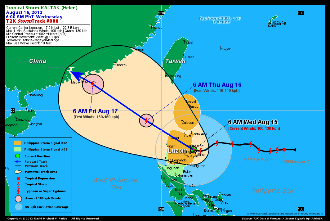
Tropical Storm KAI-TAK (HELEN) now in the vicinity of Pamplona, Cagayan...expected to pass very close to Pagudpud, Ilocos Norte. Stormy weather continues to prevail across Northern Luzon.
Meanwhile, KAI-TAK will continue to enhance the Southwest Monsoon (aka. Habagat) across the Western Sections of Luzon & Visayas incl. Metro Manila, Northern Palawan, Mindoro, Southern Tagalog Provinces and Bicol Region today until Thursday. Cloudy and windy conditions w/ scattered to passing occasional showers, rains, squalls & thunderstorms will be expected along the abovementioned areas. The seas along the coastal areas facing the West, East and North Philippine Seas will be rough and dangerous.
Residents and visitors along Northern and Central Luzon, Southern China and Taiwan should closely monitor the progress of KAI-TAK (HELEN).
Do not use this for life or death decision. This advisory is intended for additional information purposes only. Kindly refer to your country's official weather agency for local warnings, advisories & bulletins.
CURRENT STORM INFORMATION
Time/Date: 12:00 PM PhT Wed August 15, 2012
Location of Center: 18.4º N Lat 121.4º E Lon
Distance 1: 21 km (W) away from Aparri, Cagayan
Distance 2: 67 km (E) closer to Pagudpud, Ilocos Norte
Distance 3: 75 km (W) away from Sta. Ana, Cagayan
Distance 4: 87 km (ENE) closer to Laoag City
Distance 5: 94 km (NNW) away from Tuguegarao City
Distance 6: 100 km (S) away from Calayan Island
Distance 7: 138 km (NNE) closer to Vigan City
Distance 8: 140 km (NNW) away from Ilagan City
Distance 9: 188 km (NW) away from Palanan, Isabela
Distance 10: 231 km (SSW) away from Basco, Batanes
Distance 11: 238 km (NNE) away from Baguio City
Distance 12: 424 km (N) away from Metro Manila
Distance 13: 861 km SE of Hong Kong
MaxWinds (1-min avg): 95 kph (50 kts) near the center
Peak Wind Gusts: 120 kph (65 kts)
Present Movement: NW @ 22 kph (12 kts)
Towards: Cagayan-Ilocos Norte
CPA [ETA] to Ilocos Norte: Wednesday [Now til 8PM PHT]
NOAA 24hr Rainfall Accum (near center): 200 mm (High)
Minimum Central Pressure: 985 millibars (hPa)
Saffir-Simpson Typhoon Scale: TS
Size (in Diameter): 555 km (300 nm) [Average]
Wind Area Distribution (in Knots): Current Wind Profile
Max Sea Wave Height (near center): 21 ft
Possible Storm Surge Height: 1-3 ft [0.3-0.9 m]
T2K StormTracks (for Public): Google Map (Flash) | GIF
3-DAY FORECAST OUTLOOK & ANALYSIS*
KAI-TAK (HELEN) is expected to move NW-ward throughout the forecast period, with some fluctuations in its forward speed. On the forecast track, the core of KAI-TAK will continue to traverse Northern Luzon today...passing across the northernmost part of Ilocos Norte this afternoon...and will emerge over the West Philippine Sea tonight. KAI-TAK will move out of the Philippine Area of Responsibility (PAR) by Thursday noon. By Friday morning, KAI-TAK is forecast to make landfall over Southern China near Hong Kong, and will move inland across Guangdong Province through Saturday.
Maximum Sustained Winds (1-min. avg) have decreased to near 95 km/hr (50 knots) with higher gusts. Some disruption on its strength is expected as the storm traverses Northern Luzon today...and is likely to re-strengthen after 24 hours once it emerges into the West Philippine Sea/South China Sea. KAI-TAK is forecast to become a Typhoon later tonight or Thursday.
Tropical Storm Force Winds (62-100 km/hr) extend outward up to 150 kilometers (80 nautical miles) from the center. KAI-TAK is a average-sized tropical cyclone with a diameter of 555 kilometers (300 nautical miles) across.
The following is the summary of the 3-day forecast outlook on this system:
 THURSDAY NOON: Becomes a Typhoon as it moves out of the Philippine Area of Responsibility (PAR)...about 397 km NW of Laoag City [12PM AUG 16: 20.6N 117.8E @ 130kph].
FRIDAY NOON: Weakens to a Tropical Storm (TS) as it makes landfall over Southern China...about 98 km NW of Hong Kong, China [12PM AUG 17: 23.0N 113.8E @ 110kph].
SATURDAY NOON: Dissipating over Western Guangdong in Southern China...about 331 km NW of Macau [12PM AUG 18: 24.3N 111.2E @ 75kph].
*Please be reminded that the Forecast Outlook changes every 6 hours, and the Day 3 Forecast Track have an average error of 250 km...while the wind speed forecast error, averages 35 kph per day. Therefore, a turn to the left or right of its future track and changes in its wind speed must be anticipated from time to time.
EFFECTS & HAZARDS SUMMARY
Below is the summary of the storm's parts and its hazards affecting specific areas:
CENTRAL DENSE OVERCAST (CDO) - over NW Cagayan-Northern Ilocos Norte. Near-Typhoon Conditions w/ Near-Typhoon Force Winds (95-120 kph) will be expected along the CDO. (click here to know more about CDO). INNER RAINBANDS - affecting and spreading across Abra, Ilocos Sur, Kalinga, Apayao, Rest of Cagayan. Tropical Storm Conditions with Tropical Storm Force Winds (62-100 kph) will be expected along these bands. OUTER RAINBANDS - affecting & spreading across the rest of Central & Northern Luzon. Cloudy/Rainy Conditions with moderate to strong winds (<62 kph) will be expected along these bands (click here to know more about Rainbands). 24HR TOTAL RAINFALL ACCUMULATION - from 5 up to 100 mm (low to high rainfall) can be expected along areas affected by the outer & inner rainbands (see above)...with isolated amounts of 101 to 200 mm (high) along areas near the center of Kai-tak (Helen) (click to open NOAA's eTRaP graphic). COASTAL STORM SURGE FLOODING - possible 1-3 ft (0.3-0.9 m) above normal tide levels...accompanied by large and dangerous battering waves can be expected along the coastal, inland lakes and beach front areas of Northern Luzon. Very minimal damage is likely on this type of storm surge. Danger from Rip Currents or Rip Tides can be expected along the rest of the beach-front areas of Luzon. (click here to know more about Storm Surge).
CURRENT SW MONSOON INTENSITY: MODERATE >> Mostly cloudy skies with some scattered to occasional showers, rains or thunderstorms will be expected along the following affected areas: WESTERN VISAYAS, WESTERN LUZON & MINDORO incl. CALAMIAN GROUP OF ISLANDS, NORTHERN PALAWAN, BICOL REGION, SOUTHERN TAGALOG PROVINCES & METRO MANILA. Light to moderate SW'ly winds (not in excess of 50 kph) will blow across the abovementioned areas.
Important Note: Please keep in mind that the above forecast outlook, effects-hazards, current monsoon intensity, & tropical cyclone watch changes every 6 to 12 hrs!![]()
PAGASA Philippine Storm Warnings Signals
Kindly visit: The official PAGASA Website to view the Signals hoisted
External Links for TS KAI-TAK (HELEN)
PAGASA: Hourly Updates
View NOAA-CIRA's: Latest Full Wind Analysis
JTWC Latest Tracking Chart: wp1412.gif
Multi-Agency Forecast TrackMap: Near Real-Time
TSR Wind Probabilities: Current to 4 Days Ahead
JAXA TRMM Page: Latest Rainrate (in mm/hr)
NASA TRMM Page: Kai-tak's Rainrate Archives (in mm/hr)
Zoomed Satellite Pic: NOAA's Near Real-Time
Wunderground Animation: 6-12 hr. GIF Loop
CURRENT NOAA/MTSAT-2 SATELLITE IMAGE:

CURRENT TYPHOON2000.COM TRACKING MAP:
_____________________________________________________________________________
>> To know the meteorological terminologies and acronyms used on this update visit the ff:
http://typhoon2000.ph/tcterm.htm
http://www.nhc.noaa.gov/aboutgloss.shtml
http://www.nhc.noaa.gov/acronyms.shtml
__________________________________________________________________________________________
For the complete details on TS KAI-TAK (HELEN)...go visit our website @:
> http://www.typhoon2000.com
> http://www.maybagyo.com
<<<Typhoon2000.com Mobile >>>
Get the latest SMS Storm Alerts!
For more details: Text T2K TYPHOON to
2800 (Globe/TM) | 216 (Smart/TNT) | 2288 (Sun)
*Only P2.50 (Smart/Globe) / P2.00 (Sun) per msg received.
Click here on how to use this service (in PDF file)
Powered by: Synermaxx Corporation
Copyright © 2012 Typhoon2000.com All Rights Reserved
| Reply via web post | Reply to sender | Reply to group | Start a New Topic | Messages in this topic (1) |

No comments:
Post a Comment