
for Tuesday, 11 October 2011 [7:11 PM PhT]
![]()

<<<Typhoon2000.com Mobile >>>
Get the latest 6-hrly SMS Storm Alerts on RAMON!
For more details: Text T2K TYPHOON to
2800 (Globe/TM) | 216 (Smart/TNT) | 2288 (Sun)
*Only P2.50 (Smart/Globe) / P2.00 (Sun) per msg received.
Click here on how to use this service (in PDF file)
Powered by: Synermaxx Corporation
Typhoon2000 (T2K) NEWS (Tuesday Oct 11 2011):
Currently issuing 6-hrly web, SMS, email, & android (iTyphoon) updates (except 12:00 Midnight) on BANYAN (RAMON).
BANYAN (RAMON) MAX WIND SPEED PER AGENCY:
+ USA (JTWC/1-min avg): 55 km/hr
+ Japan (JMA/10-min avg): 65 km/hr
+ Philippines (PAGASA/10-min avg): 65 km/hr
+ Beijing (NMC/2-min avg): 65 km/hr
+ Taiwan (CWB/10-min avg): -- km/hr
+ Korea (KMA/10-min avg): 65 km/hr
+ Hong Kong (HKO/10-min avg): -- km/hr
:: Click here to see Multi-Agency Forecast Tracks
TROPICAL STORM BANYAN [RAMON/23W/1120]
T2K PUBLIC ADVISORY NUMBER 005
6:00 PM PhT (10:00 GMT) Tue 11 October 2011
Source: T2K Analysis/JTWC TC Warning #006/JMA 06Z Warning/SatFixes
View: Advisory Archives (2004-2011)
23W (RAMON) has strengthened into a Tropical Storm...now internationally named BANYAN - a kind of tree (named by Hong Kong)...tracking faster northwesterly. Its outer rainbands spreading across Visayas, Mindanao & Bicol Region.
Residents and visitors along Northern Mindanao, Visayas & Bicol Region should closely monitor the progress of 23W (RAMON).
Do not use this for life or death decision. This advisory is intended for additional information purposes only. Kindly refer to your country's official weather agency for local warnings, advisories & bulletins.
CURRENT STORM INFORMATION
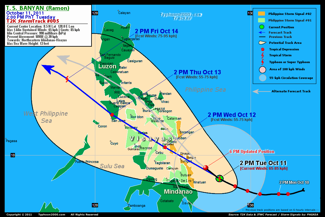
Time/Date: 6:00 PM PhT Tue October 11 2011
Location of Center: 9.2º N Lat 127.1º E Lon
Distance 1: 125 km NE of Hinatuan, Surigao DS
Distance 2: 188 km ESE of Surigao City
Distance 3: 179 km ENE of Butuan City
Distance 4: 325 km SSE of Borongan City
Distance 5: 261 km SE of Guiuan, E.Samar
Distance 6: 320 km SE of Tacloban City
Distance 7: 339 km SE of Ormoc City
Distance 8: 365 km ESE of Tagbilaran City
Distance 9: 371 km SE of Metro Cebu
Distance 10: 486 km ESE of Bacolod City
Distance 11: 520 km ESE of Iloilo City
Distance 12: 515 km SE of Masbate City
MaxWinds (1-min avg): 65 kph (35 kts) near the center
Peak Wind Gusts: 85 kph (45 kts)
Present Movement: NW @ 20 kph (11 kts)
Towards: Surigao-Leyte Area
CPA [ETA] to Surigao DN: Wed Morning [5-7am PhT]
6-12hr Rainfall Accum (near center): 200 mm (High)
Minimum Central Pressure: 998 millibars (hPa)
Saffir-Simpson Typhoon Scale: Tropical Storm
Size (in Diameter): 665 km (360 nm) [Average]
Wind Area Distribution (in Knots): Current Wind Profile
Max Sea Wave Height (near center): 13 ft
Possible Storm Surge Height: 1-3 ft [0.3-0.9 m]
T2K TrackMap (for Public): 6 PM PhT Tue Oct 11
3-DAY FORECAST OUTLOOK & ANALYSIS*
BANYAN (RAMON) is expected to continue moving NW-ward during the next 2 to 3 days...with a decrease on its forward speed later in the forecast. On the forecast track, the core of the storm will be approaching the NE Coast of Surigao Del Norte tonight...passing over or very near Surigao City Wednesday morning...and will traverse the major islands of the Visayas (SW Leyte-Camotes Island-Northern Cebu-Northern Coast of Negros-Extreme Northern Panay) Wednesday afternoon through Thursday morning. BANYAN will be crossing Southern Mindoro Thursday afternoon...and will be over the West Philippine Sea on Friday.
Maximum Sustained Winds (1-min. avg) have increased to near 65 km/hr (35 knots) with higher gusts. BANYAN (RAMON) is now a Tropical Storm (TS) on the Saffir-Simpson Tropical Cyclone Scale...and should still intensify before it interacts with the Visayan Islands Wednesday.
Tropical Storm Force Winds (62-85 km/hr) extend outward up to 30 kilometers (15 nautical miles). BANYAN (RAMON) is an average-sized tropical cyclone with a diameter of 665 kilometers (360 nautical miles).
The following is the summary of the 3-day forecast outlook on this system:
 WEDNESDAY AFTERNOON: In the vicinity of Camotes Islands...approaching Northern Cebu...downgraded to a Tropical Depression (TD). [2PM OCT 12: 10.5N 125.4E @ 55kph].
THURSDAY AFTERNOON: Maintains its TD strength...traversing Southern Mindoro, just to the north of San Jose [2PM OCT 13: 12.6N 121.1E @ 55kph].
FRIDAY AFTERNOON: Strengthens into a Tropical Storm (TS) while moving NW'ly across the West Philippine Sea [2PM OCT 14: 14.9N 118.2E @ 75kph].
**Alternate Forecast Scenario (AFS): There is a possibility that BANYAN (RAMON) will move more northwesterly to NNW-ward and pass over Tacloban City instead...cutting across Biliran-Ticao...and moving along the western shores of Sorsogon, Albay, Camarines Sur...and make landfall along Southern Quezon towards Metro Manila. This scenario may happen if the High Pressure Steering Ridge northeast of the storm will weaken.
BANYAN's (RAMON's) CLOSEST POINT OF APPROACH (CPA)*
SURIGAO DEL NORTE: Passing very near or over Surigao City [ETA: 6:00-8:00 AM Local Time, Wednesday].
NORTHERN CEBU: Passing more or less 60 km north of Metro Cebu [ETA: 6:00-8:00 PM Wednesday].
BACOLOD-ILOILO AREA: Passing more or less 80 km north of Bacolod & Iloilo Cities [ETA: 11:00 PM Wednesday-1:00 AM Thursday].
CAPIZ: Passing very near or over Roxas City [ETA: 12:00-2:00 AM Thursday].
AKLAN: Passing more or less 25 km northeast of Boracay [ETA: 6:00-8:00 AM Thursday].
*Please be reminded that the Forecast Outlook changes every 6 hours, and the Day 3 Forecast Track have an average error of 250 km...while the wind speed forecast error, averages 35 kph per day. Therefore, a turn to the left or right of its future track and changes in its wind speed must be anticipated from time to time.
EFFECTS & HAZARDS SUMMARY
Below is the summary of the storm's parts and its hazards affecting specific areas:
INNER RAINBANDS - affecting and spreading across Surigao Provinces, Siargao & Dinagat Islands. Tropical Storm Conditions w/ Tropical Storm Force Winds (62-85 kph) will be expected along these bands. DEVELOPING RAINBANDS - affecting & spreading across rest of Visayas, Mindanao & Bicol Region. Tropical Depression Conditions w/ moderate to strong winds (25-61 kph) will be expected along these bands (click here to know more about Rainbands). 6-12HR TOTAL RAINFALL ACCUMULATION - from 5 up to 150 mm (low to high rainfall) can be expected along areas affected by the outer & inner rainbands (see above)...with isolated amounts of 151 to 200 mm (high) along areas near the center of BANYAN (RAMON). (click to open NOAA's eTRaP graphic).
Important Note: Please keep in mind that the above forecast outlook, effects-hazards, current monsoon intensity, & tropical cyclone watch changes every 6 to 12 hrs!![]()
PAGASA Philippine Storm Warnings Signals
PHILIPPINE STORM WARNING SIGNAL # TWO (2) 
Now In Effect: SOUTHERN LEYTE, EASTERN SAMAR, SURIGAO PROVINCES, SIARGAO & DINAGAT ISLANDS.
The above areas will experience stormy weather tonight until tomorrow (with winds not exceeding 100 kph for #02). Coastal waters will be rough to very rough and extremely dangerous to all types of seacrafts.
PHILIPPINE STORM WARNING SIGNAL # ONE (1)
In Effect: MASBATE, TICAO, ROMBLON, SORSOGON, NORTHERN LEYTE, BILIRAN, BOHOL, CEBU, NORTHERN NEGROS, NORTHERN SAMAR, WESTERN SAMAR, PANAY, GUIMARAS, AGUSAN PROVINCES, MISAMIS ORIENTAL, & CAMIGUIN.
The above areas will have rains and winds of not more than 60 kph tonight and tomorrow. Coastal waters will be moderate to rough.
Residents living in low-lying and mountainous areas under Public Storm Warning Signals are alerted against flashfloods, mudslides and landslides...while those living in coastal & beach-front areas are advised to seek higher grounds due to possible storm surge (aka. big waves).
External Links for TS BANYAN (RAMON)
PAGASA@Twitter: Hourly Updates
View NOAA-CIRA's: Latest Full Wind Analysis
JTWC Latest Tracking Chart: wp2311.gif
Multi-Agency Forecast TrackMap: Near Real-Time
TSR Wind Probabilities: Current to 5 days Ahead
JAXA TRMM Page: Latest Rainrate (in mm/hr)
Zoomed Satellite Pic: NOAA's Near Real-Time
Wunderground Animation: 6-12 hr. GIF Loop
TYPHOON2000 LATEST STORMTRACK:
>> To know the meteorological terminologies and acronyms used on this update visit the ff:
http://typhoon2000.ph/tcterm.htm
http://www.nhc.noaa.gov/aboutgloss.shtml
http://www.nhc.noaa.gov/acronyms.shtml
__________________________________________________________________________________________
For the complete details on TS BANYAN (RAMON)...go visit our website @:
> http://www.typhoon2000.com
> http://www.maybagyo.com
Copyright © 2011 Typhoon2000.com All Rights Reserved

No comments:
Post a Comment