
for Tuesday, 11 October 2011 [6:47 AM PhT]
![]()

<<<Typhoon2000.com Mobile >>>
Get the latest 6-hrly SMS Storm Alerts on RAMON!
For more details: Text T2K TYPHOON to
2800 (Globe/TM) | 216 (Smart/TNT) | 2288 (Sun)
*Only P2.50 (Smart/Globe) / P2.00 (Sun) per msg received.
Click here on how to use this service (in PDF file)
Powered by: Synermaxx Corporation
Typhoon2000 (T2K) NEWS (Tuesday Oct 11 2011):
Currently issuing 6-hrly web, SMS, email, & android (iTyphoon) updates (except 12:00 Midnight) on 23W (RAMON).
23W (RAMON) MAX WIND SPEED PER AGENCY:
+ USA (JTWC/1-min avg): 55 km/hr
+ Japan (JMA/10-min avg): 55 km/hr
+ Philippines (PAGASA/10-min avg): 55 km/hr
+ Beijing (NMC/2-min avg): -- km/hr
+ Taiwan (CWB/10-min avg): -- km/hr
+ Korea (KMA/10-min avg): -- km/hr
+ Hong Kong (HKO/10-min avg): -- km/hr
TROPICAL DEPRESSION 23W [RAMON]
T2K PUBLIC ADVISORY NUMBER 003
6:00 AM PhT (22:00 GMT) Tue 11 October 2011
Source: T2K Analysis/JTWC TC Warning #004/SatFixes
View: Advisory Archives (2004-2011)
Tropical Depression 23W (RAMON) has maintained its intensity while moving closer to Northeastern Mindanao...circulation expands...Outer rainbands now spreading across Mindanao & Visayas incl. Masbate.
Residents and visitors along Northern Mindanao, Visayas & Southern Bicol should closely monitor the progress of 23W (RAMON).
Do not use this for life or death decision. This advisory is intended for additional information purposes only. Kindly refer to your country's official weather agency for local warnings, advisories & bulletins.
CURRENT STORM INFORMATION
Time/Date: 6:00 AM PhT Tue October 11 2011
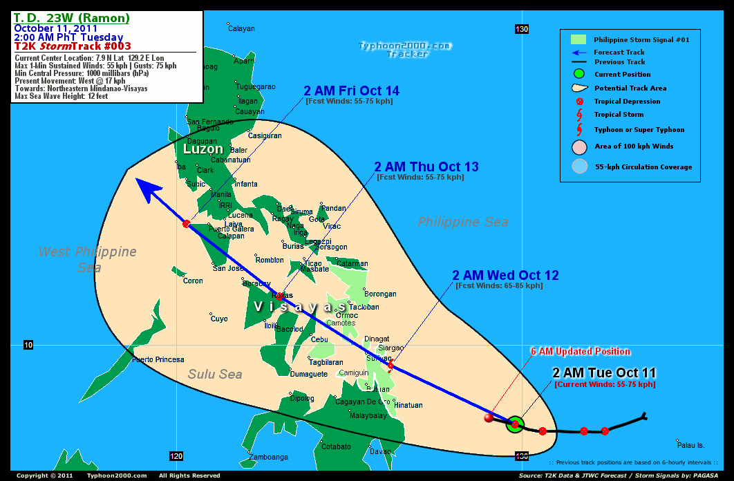
Location of Center: 7.9º N Lat 129.2º E Lon
Distance 1: 324 km ESE of Hinatuan, Surigao DS
Distance 2: 407 km ENE of Metro Davao
Distance 3: 422 km ESE of Butuan City
Distance 4: 458 km SE of Surigao City
Distance 5: 626 km ESE of Tagbilaran City
Distance 6: 611 km SE of Ormoc City
Distance 7: 596 km SE of Tacloban City
Distance 8: 523 km SE of Guiuan, E.Samar
Distance 9: 640 km SE of Metro Cebu
Distance 10: 754 km SE of Bacolod City
Distance 11: 788 km SE of Iloilo City
Distance 12: 585 km SSE of Borongan City
MaxWinds (1-min avg): 55 kph (30 kts) near the center
Peak Wind Gusts: 75 kph (45 kts)
Present Movement: West @ 17 kph (09 kts)
Towards: Surigao-Leyte Area
CPA [ETA] to Surigao DN: Wed Morning [5-7am PhT]
24hr Rainfall Accum (near center): 450 mm (High)
Minimum Central Pressure: 1000 millibars (hPa)
Saffir-Simpson Typhoon Scale: Tropical Depression
Size (in Diameter): 400 km (215 nm) [Average]
Wind Area Distribution (in Knots): Current Wind Profile
Max Sea Wave Height (near center): 12 ft
Possible Storm Surge Height: 0 ft [0 m]
T2K TrackMap (for Public): 6 PM PhT Mon Oct 10
3-DAY FORECAST OUTLOOK & ANALYSIS*
23W (RAMON) is expected to turn sharply WNW to NW-ward during the next 2 to 3 days...with little change on its forward speed. On the forecast track, the core of the depression will be approaching the NE Coast of Surigao Del Norte tonight...passing over or very near Surigao City Wednesday morning...and will traverse the major islands of the Visayas (Camotes Sea-Northern Cebu-Northern Coast of Negros-Extreme Northern Panay) Wednesday afternoon through Thursday morning. 23W will be crossing Mindoro Thursday night...and will be near Lubang Island early morning Friday.
Maximum Sustained Winds (1-min. avg) remain near 55 km/hr (30 knots) with higher gusts. 23W (RAMON) is a Tropical Depression on the Saffir-Simpson Tropical Cyclone Scale...and could become a Tropical Storm (TS) today.
The following is the summary of the 3-day forecast outlook on this system:
 WEDNESDAY EARLY MORNING: Upgraded to minimal Tropical Storm (TS) as it bears down the coast of Surigao Del Norte. [2AM OCT 12: 9.4N 126.2E @ 65kph].
THURSDAY EARLY MORNING: Off the Northeastern portion of Panay Island...downgraded to a Tropical Depression (TD) due to some land interaction [2AM OCT 13: 11.4N 123.0E @ 55kph].
FRIDAY EARLY MORNING: Just along the Northwestern Coast of Mindoro...near Lubang Island [2AM OCT 14: 13.5N 120.3E @ 55kph].
23W's (RAMON's) CLOSEST POINT OF APPROACH (CPA)*
SURIGAO DEL NORTE: Passing very near or over Surigao City [ETA: 5:00-7:00 AM Local Time, Wednesday].
CEBU: Passing more or less 60 km north of Metro Cebu [ETA: 5:00-7:00 PM Wednesday].
BACOLOD-ILOILO AREA: Passing more or less 70 km north of Bacolod & Iloilo Cities [ETA: 12:00-2:00 AM Thursday].
*Please be reminded that the Forecast Outlook changes every 6 hours, and the Day 3 Forecast Track have an average error of 250 km...while the wind speed forecast error, averages 35 kph per day. Therefore, a turn to the left or right of its future track and changes in its wind speed must be anticipated from time to time.
EFFECTS & HAZARDS SUMMARY
Below is the summary of the storm's parts and its hazards affecting specific areas:
DEVELOPING RAINBANDS - affecting & spreading across Visayas & Mindanao including Masbate. Tropical Depression Conditions w/ moderate to strong winds (25-61 kph) will be expected along these bands (click here to know more about Rainbands). 24HR TOTAL RAINFALL ACCUMULATION - from 5 up to 200 mm (low to high rainfall) can be expected along areas affected by the outer & inner rainbands (see above)...with isolated amounts of 201 to 450 mm (high) along areas near the center of 23W (RAMON). (click to open NOAA's eTRaP graphic).
Important Note: Please keep in mind that the above forecast outlook, effects-hazards, current monsoon intensity, & tropical cyclone watch changes every 6 to 12 hrs!![]()
PAGASA Philippine Storm Warnings Signals
PHILIPPINE STORM WARNING SIGNAL # ONE (1) 
Now In Effect: EASTERN SAMAR, WESTERN SAMAR, LEYTE PROVINCES, BOHOL, BILIRAN & CAMOTES ISLANDS, SURIGAO DEL NORTE, SURIGAO DEL SUR, SIARGAO ISLAND, AGUSAN DEL NORTE, CAMIGUIN ISLAND, & DINAGAT GROUP OF ISLANDS.
The above areas will have rains and winds of not more than 60 kph today. Coastal waters will be moderate to rough.
Residents living in low-lying and mountainous areas under Public Storm Warning Signals are alerted against flashfloods, mudslides and landslides...while those living in coastal & beach-front areas are advised to seek higher grounds due to possible storm surge (aka. big waves).
External Links for TD 23W (RAMON)
PAGASA@Twitter: Hourly Updates
View NOAA-CIRA's: Latest Full Wind Analysis
JTWC Latest Tracking Chart: wp2311.gif
TSR Wind Probabilities: Current to 5 days Ahead
JAXA TRMM Page: Latest Rainrate (in mm/hr)
Zoomed Satellite Pic: NOAA's Near Real-Time
Wunderground Animation: 6-12 hr. GIF Loop
TYPHOON2000 CURRENT STORMTRACK:
>> To know the meteorological terminologies and acronyms used on this update visit the ff:
http://typhoon2000.ph/tcterm.htm
http://www.nhc.noaa.gov/aboutgloss.shtml
http://www.nhc.noaa.gov/acronyms.shtml
__________________________________________________________________________________________
For the complete details on TD 23W (RAMON)...go visit our website @:
> http://www.typhoon2000.com
> http://www.maybagyo.com
Copyright © 2011 Typhoon2000.com All Rights Reserved

No comments:
Post a Comment