
for Wednesday, 28 September 2011 [12:45 PM PhT]
![]()

<<<Typhoon2000.com Mobile >>>
Get the latest 6-hrly SMS Storm Alerts on PEDRING!
For more details: Text T2K TYPHOON to
2800 (Globe/TM) | 216 (Smart/TNT) | 2288 (Sun)
*Only P2.50 (Smart/Globe) / P2.00 (Sun) per msg received.
Click here on how to use this service (in PDF file)
Powered by: Synermaxx Corporation
Typhoon2000 (T2K) NEWS (Wednesday Sep 28 2011):
Currently issuing 6-hrly web, email, & android (iTyphoon) updates (except 12:00 Midnight) on NESAT (PEDRING).
NESAT (PEDRING) MAX WIND SPEED PER AGENCY:
+ USA (JTWC/1-min avg): 130 km/hr
+ Japan (JMA/10-min avg): 120 km/hr
+ Philippines (PAGASA/10-min avg): 130 km/hr
+ Beijing (NMC/2-min avg): 145 km/hr
+ Taiwan (CWB/10-min avg): 125 km/hr
+ Korea (KMA/10-min avg): 140 km/hr
+ Hong Kong (HKO/10-min avg): 130 km/hr
:: Click here to see Multi-Agency Forecast Tracks
TYPHOON NESAT [PEDRING/20W/1117]
T2K PUBLIC ADVISORY NUMBER 018
12:00 PM PhT (04:00 GMT) Wed 28 September 2011
Source: T2K Analysis/JTWC TC Warning #019/SatFixes
View: Advisory Archives (2004-2011)
The large Typhoon NESAT (PEDRING) weakens slightly as it continues to move farther away from Luzon. The west coast of Luzon is still under the broad effects of its outer rain bands.
Meanwhile, NALGAE has strengthened into a Tropical Storm as it drifts slowly towards the North Philippine Sea...forecast to enter PAR tomorrow.
Residents and visitors along Southern China particularly Hainan should closely monitor the progress of NESAT (PEDRING).
Do not use this for life or death decision. This advisory is intended for additional information purposes only. Kindly refer to your country's official weather agency for local warnings, advisories & bulletins.
CURRENT STORM INFORMATION
Time/Date: 12:00 PM PhT Wed September 28 2011
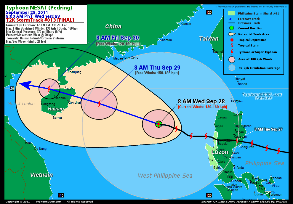
Location of Eye: 17.3º N Lat 116.2º E Lon
Distance 1: 447 km West of Vigan City
Distance 2: 477 km WSW of Laoag City
Distance 3: 443 km WNW of San Fernando City
Distance 4: 457 km NW of Dagupan City
Distance 5: 479 km WNW of Baguio City
Distance 6: 584 km SSE of Hong Kong
Distance 7: 604 km NW of Metro Manila
Distance 8: 609 km SSE of Macau
Distance 9: 631 km SE of Hainan Is.
MaxWinds (1-min avg): 130 kph (70 kts) near the center
Peak Wind Gusts: 160 kph (85 kts)
Present Movement: West @ 20 kph (11 kts)
Towards: Hainan-Northern Vietnam
12-18hr Rainfall Accum (near center): 230 mm (High)
Rainrate (near center): 20-30 mm/hr (Moderate)
Minimum Central Pressure: 970 millibars (hPa)
Saffir-Simpson Typhoon Scale: Category 1
Size (in Diameter): 1,110 km (600 nm) [Very Large]
Wind Area Distribution (in Knots): Current Wind Profile
Max Sea Wave Height (near center): 24 ft
Possible Storm Surge Height: 4-5 ft [1.2-1.7 m]
T2K Final TrackMap (for Public): 8 AM PhT Wed Sep 28
3-DAY FORECAST OUTLOOK & ANALYSIS*
NESAT (PEDRING) will continue to move generally west-northwest throughout the forecast period. On the forecast track, the core of the typhoon will leave the Philippine Area of Responsibility (PAR) this afternoon...and making landfall over Hainan Island Thursday evening. NESAT will move across the Gulf of Tonkin and make its final landfall over Northern Vietnam near Hanoi on Saturday.
Maximum Sustained Winds (1-min. avg) have decreased to near 130 km/hr (70 knots) with higher gusts. NESAT is a Category 1 Typhoon on the Saffir-Simpson Tropical Cyclone Scale. Re-strengthening of NESAT will be expected during the next 24 hours.
Typhoon Force Winds (118 km/hr or more) extend outward up to 45 kilometers (25 nautical miles) from the center...and Tropical Storm Force Winds (62-117 km/hr) extend outward up to 305 kilometers (165 nautical miles). NESAT remains a very large-sized tropical cyclone with a diameter of 1,100 kilometers (600 nautical miles).
The following is the summary of the 3-day forecast outlook on this system:
 THURSDAY MORNING: Intensifying as it approaches Hainan Island [8AM SEP 29: 19.0N 112.6E @ 150kph].
FRIDAY MORNING: Over the northwestern coast of Hainan...weakens slightly [8AM SEP 30: 20.0N 109.2E @ 120kph].
SATURDAY MORNING: Downgraded to a Tropical Storm as it makes landfall over Northern Vietnam...about 38 km SE of Hanoi City [8AM OCT 01: 20.8 106.1E @ 85kph].
*Please be reminded that the Forecast Outlook changes every 6 hours, and the Day 3 Forecast Track have an average error of 250 km...while the wind speed forecast error, averages 35 kph per day. Therefore, a turn to the left or right of its future track and changes in its wind speed must be anticipated from time to time.
EFFECTS & HAZARDS SUMMARY
NESAT's (PEDRING) circulation remains intact & very large with little development, however its central convection has become somewhat loose. Below is the summary of the storm's parts and its hazards affecting specific areas:
CLOUD-FILLED EYE - over water (West Philippine Sea). Possible calm and lull conditions (with <20 kph winds) will be expected inside the eye (click here to know more about the EYE). EYEWALL - over water (West Philippine Sea). Typhoon Conditions with Typhoon Force Winds (>118 kph) will be expected within this wall (click here to know more about the Eyewall). INNER RAINBANDS - over water (West Philippine Sea)...no effects to land. Tropical Storm Conditions w/ Tropical Storm Force Winds (62-117 kph) will be expected along these bands. OUTER RAINBANDS - affecting & spreading across Western Luzon...and will reach the coast of Hainan Island and Western Guangdong tonight. Tropical Depression Conditions w/ moderate to strong winds (25-61 kph) will be expected along these bands (click here to know more about Rainbands). 12-18HR TOTAL RAINFALL ACCUMULATION - from 5 up to 75 mm (low to high rainfall) can be expected along areas affected by the outer & inner rainbands (see above)...with isolated amounts of 76 to 250 mm (high) along areas near the center of NESAT (PEDRING). (click to open NOAA's eTRaP graphic). COASTAL STORM SURGE FLOODING - possible 4-5 ft [1.2-1.7 m] above normal tide levels...accompanied by large and dangerous battering waves can be expected along the coastal and beach front areas of Western Luzon. Minimal damage is likely on this type of storm surge. Danger from Rip Currents or Rip Tides can be expected along the beach-front areas of Luzon & Visayas. (click here to know more about Storm Surge).
CURRENT SW MONSOON INTENSITY: STRONG >> Mostly cloudy skies with passing occasional showers, rains or thunderstorms w/ squalls will be expected across the following affected areas: WESTERN VISAYAS, SOUTHERN TAGALOG PROVINCES, BORACAY, MINDORO, METRO MANILA, WESTERN BICOL & PALAWAN. Moderate to strong SW'ly winds (not in excess of 75 kph) will blow across the abovementioned areas.
Important Note: Please keep in mind that the above forecast outlook, effects-hazards, current monsoon intensity, & tropical cyclone watch changes every 6 to 12 hrs!![]()
PAGASA Philippine Storm Warnings Signals
PHILIPPINE STORM WARNING SIGNAL # ONE (1) 
In Effect: ZAMBALES, LA UNION & PANGASINAN.
The above areas will have rains and winds of not more than 60 kph today. Coastal waters will be moderate to rough.
Residents living in low-lying and mountainous areas under Public Storm Warning Signals are alerted against flashfloods, mudslides and landslides...while those living in coastal & beach-front areas are advised to seek higher grounds due to possible storm surge (aka. big waves).
External Links for TY NESAT (PEDRING)
PAGASA@Twitter: Hourly Updates
View NOAA-CIRA's: Latest Full Wind Analysis
JTWC Latest Tracking Chart: wp2011.gif
Multi-Agency Forecast TrackMap: Near Real-Time
TSR Wind Probabilities: Current to 5 Days Ahead
JAXA TRMM Page: Latest Rainrate (in mm/hr)
Zoomed Satellite Pic: NOAA's Near Real-Time
Wunderground Animation: 6-12 hr. GIF Loop
TYPHOON2000 FINAL STORMTRACK:
>> To know the meteorological terminologies and acronyms used on this update visit the ff:
http://typhoon2000.ph/tcterm.htm
http://www.nhc.noaa.gov/aboutgloss.shtml
http://www.nhc.noaa.gov/acronyms.shtml
__________________________________________________________________________________________
For the complete details on TY NESAT (PEDRING)...go visit our website @:
> http://www.typhoon2000.com
> http://www.maybagyo.com
Copyright © 2011 Typhoon2000.com All Rights Reserved

No comments:
Post a Comment