
for Tuesday, 27 September 2011 [2:00 PM PhT]
![]()

<<<Typhoon2000.com Mobile >>>
Get the latest 3-hrly SMS Storm Alerts on PEDRING!
For more details: Text T2K TYPHOON to
2800 (Globe/TM) | 216 (Smart/TNT) | 2288 (Sun)
*Only P2.50 (Smart/Globe) / P2.00 (Sun) per msg received.
Click here on how to use this service (in PDF file)
Powered by: Synermaxx Corporation
Typhoon2000 (T2K) NEWS (Monday Sep 26 2011):
Please be informed that due to power interruptions caused by PEDRING's strong winds, T2K updates will be delayed from time to time. Kindly bear with me. Thank you ~ MVP. Currently issuing 3-hrly web, email, & android (iTyphoon) updates (except 12:00 Midnight) on NESAT (PEDRING).
NESAT (PEDRING) MAX WIND SPEED PER AGENCY:
+ USA (JTWC/1-min avg): 175 km/hr
+ Japan (JMA/10-min avg): 140 km/hr
+ Philippines (PAGASA/10-min avg): 120 km/hr
+ Beijing (NMC/2-min avg): 140 km/hr
+ Taiwan (CWB/10-min avg): 140 km/hr
+ Korea (KMA/10-min avg): 145 km/hr
+ Hong Kong (HKO/10-min avg): 130 km/hr
:: Click here to see Multi-Agency Forecast Tracks
TYPHOON NESAT [PEDRING/20W/1117]
T2K PUBLIC ADVISORY NUMBER 015
12:00 PM PhT (04:00 GMT) Tue 27 September 2011
Source: T2K Analysis/JTWC TC Warning #015/SatFixes
View: Advisory Archives (2004-2011)
The large core of Typhoon NESAT (PEDRING) now over Benguet...passing very close to Baguio City. Typhoon conditions prevailing across NW Luzon.
Most of the typhoon's outer rainbands are covering the whole of Luzon and portions of Northern Visayas.
Residents and visitors along Luzon should closely monitor the progress of NESAT (PEDRING).
Do not use this for life or death decision. This advisory is intended for additional information purposes only. Kindly refer to your country's official weather agency for local warnings, advisories & bulletins.
CURRENT STORM INFORMATION
Time/Date: 12:00 PM PhT Tue September 27 2011
Location of Eye: 16.5º N Lat 120.6º E Lon
Distance 1: 11 km North of Baguio City
Distance 2: 34 km ESE of San Fernando City
Distance 3: 64 km NNE of Dagupan City
Distance 4: 119 km NNW of Cabanatuan City
Distance 5: 124 km South of Vigan City
Distance 6: 145 km North of Clark/Angeles City
Distance 7: 148 km NNE of Iba, Zambales
Distance 8: 189 km South of Laoag City
Distance 9: 192 km NNE of Subic/Olongapo
Distance 10: 218 km NNW of Metro Manila
MaxWinds (1-min avg): 140 kph (75 kts) near the center
Peak Wind Gusts: 175 kph (95 kts)
Present Movement: West @ 26 kph (14 kts)
Towards: La Union-West Philippine Sea
24hr Rainfall Accum (near center): 400 mm (High)
Rainrate (near center): 25-30 mm/hr (Moderate)
Minimum Central Pressure: 967 millibars (hPa)
Saffir-Simpson Typhoon Scale: Category 1
Size (in Diameter): 905 km (490 nm) [Very Large]
Wind Area Distribution (in Knots): Current Wind Profile
Max Sea Wave Height (near center): XX ft
Possible Storm Surge Height: 4-5 ft [1.2-1.7 m]
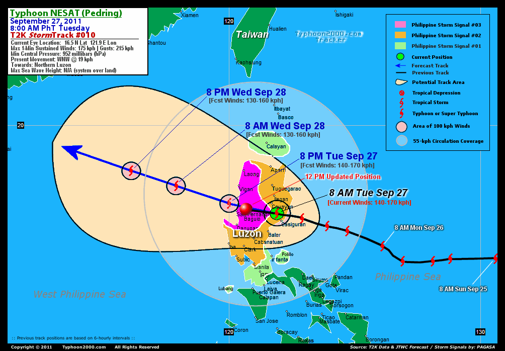
T2K TrackMap (for Public): 12 PM PhT Tue Sep 27
3-DAY FORECAST OUTLOOK & ANALYSIS*
NESAT (PEDRING) will remain a "Straight-Runner" where it will maintain its WNW movement troughout the forecast period. On the forecast track, the core of the typhoon will exit Northern Luzon via La Union-Ilocos Sur Area, and emerge over the West Philippine Sea later this afternoon. During the next 2 to 3 days, NESAT will be over the West Philippine/South China Sea, leaving the Philippine Area of Responsibility (PAR) Wednesday...and making landfall over Hainan Island on Friday.
Maximum Sustained Winds (1-min. avg) have decreased to near 140 km/hr (75 knots) with higher gusts. NESAT is a Category 1 Typhoon on the Saffir-Simpson Tropical Cyclone Scale. It will re-intensify once again while moving into the West Philippine Sea/South China Sea.
Typhoon Force Winds (118 km/hr or more) extend outward up to 45 kilometers (25 nautical miles) from the center...and Tropical Storm Force Winds (62-117 km/hr) extend outward up to 150 kilometers (80 nautical miles). NESAT is a very large-sized tropical cyclone with a diameter of 905 kilometers (490 nautical miles).
The following is the summary of the 3-day forecast outlook on this system:
 WEDNESDAY MORNING: Over the West Philippine Sea...regaining intensity as it moves oout of the Philippine Area of Responsibility (PAR) [8AM SEP 28: 17.6N 117.9E @ 130kph].
THURSDAY MORNING: Gaining strength slightly as it moves toward Hainan [8AM SEP 29: 18.8N 114.4E @ 140kph].
FRIDAY MORNING: Just along the northern shores of Hainan Island [8AM SEP 30: 19.8 111.2E @ 140kph].
*Please be reminded that the Forecast Outlook changes every 6 hours, and the Day 3 Forecast Track have an average error of 250 km...while the wind speed forecast error, averages 35 kph per day. Therefore, a turn to the left or right of its future track and changes in its wind speed must be anticipated from time to time.
EFFECTS & HAZARDS SUMMARY
NESAT's (PEDRING) circulation remains intact & very large despite its land crossing. Below is the summary of the storm's parts and its hazards affecting specific areas:
CLOUD-FILLED EYE - Over Benguet. Possible calm and lull conditions (with <20 kph winds) will be expected inside the eye (click here to know more about the EYE). EYEWALL - affecting and moving across La Union, Ilocos Sur, Ifugao Provinces. Typhoon Conditions with Typhoon Force Winds (>118 kph) will be expected within this wall (click here to know more about the Eyewall). INNER RAINBANDS - affecting & spreading across the rest of Northern Luzon. Tropical Storm Conditions w/ Tropical Storm Force Winds (62-117 kph) will be expected along these bands. OUTER RAINBANDS - affecting & spreading across the whole of Luzon including Metro Manila, Mindoro, Calamian Group, and Northern Visayas. Tropical Depression Conditions w/ moderate to strong winds (25-61 kph) will be expected along these bands (click here to know more about Rainbands). 24HR TOTAL RAINFALL ACCUMULATION - from 5 up to 250 mm (low to high rainfall) can be expected along areas affected by the outer & inner rainbands (see above)...with isolated amounts of 251 to 400 mm (high) along areas near the center of NESAT (PEDRING). (click to open NOAA's eTRaP graphic). COASTAL STORM SURGE FLOODING - possible 4-5 ft [1.2-1.7 m] above normal tide levels...accompanied by large and dangerous battering waves can be expected along the coastal and beach front areas of Western Luzon. Minimal damage is likely on this type of storm surge. Danger from Rip Currents or Rip Tides can be expected along the beach-front areas of Luzon & Visayas. (click here to know more about Storm Surge).
CURRENT SW MONSOON INTENSITY: STRONG >> Mostly cloudy skies with passing occasional showers, rains or thunderstorms w/ squalls will be expected across the following affected areas: REST OF VISAYAS, SOUTHERN LUZON, BICOL REGION, & PALAWAN. Moderate to strong SW'ly winds (not in excess of 75 kph) will blow across the abovementioned areas.
Important Note: Please keep in mind that the above forecast outlook, effects-hazards, current monsoon intensity, & tropical cyclone watch changes every 6 to 12 hrs!![]()
PAGASA Philippine Storm Warnings Signals
PHILIPPINE STORM SIGNAL # THREE (3) 
In Effect: -ILOCOS PROVINCES, ABRA, KALINGA, MT. PROV, IFUGAO, BENGUET, LA UNION, NUEVA VIZCAYA, & PANGASINAN.
PHILIPPINE STORM WARNING SIGNAL # TWO (2)
In Effect: REST OF NORTHERN LUZON, METRO MANILA, NUEVA ECIJA, ZAMBALES, PAMPANGA, TARLAC, BULACAN, & BATAAN.
The above areas will continue to experience stormy weather today (with winds not exceeding 100 kph for #02 and 100-185 kph for #03). Coastal waters will be rough to very rough and extremely dangerous to all types of seacrafts.
PHILIPPINE STORM WARNING SIGNAL # ONE (1)
In Effect: BABUYAN, CALAYAN, NORTHERN QUEZON, POLILLO, RIZAL, LAGUNA, BATANGAS, LUBANG IS., & CAVITE.
The above areas will have rains and winds of not more than 60 kph today. Coastal waters will be moderate to rough.
Residents living in low-lying and mountainous areas under Public Storm Warning Signals are alerted against flashfloods, mudslides and landslides...while those living in coastal & beach-front areas are advised to seek higher grounds due to possible storm surge (aka. big waves).
External Links for TY NESAT (PEDRING)
PAGASA@Twitter: Hourly Updates
View NOAA-CIRA's: Latest Full Wind Analysis
JTWC Latest Tracking Chart: wp2011.gif
Multi-Agency Forecast TrackMap: Near Real-Time
TSR Wind Probabilities: Current to 5 Days Ahead
JAXA TRMM Page: Latest Rainrate (in mm/hr)
Zoomed Satellite Pic: NOAA's Near Real-Time
Wunderground Animation: 6-12 hr. GIF Loop
TYPHOON2000 CURRENT STORMTRACK:
>> To know the meteorological terminologies and acronyms used on this update visit the ff:
http://typhoon2000.ph/tcterm.htm
http://www.nhc.noaa.gov/aboutgloss.shtml
http://www.nhc.noaa.gov/acronyms.shtml
__________________________________________________________________________________________
For the complete details on TY NESAT (PEDRING)...go visit our website @:
> http://www.typhoon2000.com
> http://www.maybagyo.com
Copyright © 2011 Typhoon2000.com All Rights Reserved

No comments:
Post a Comment