
for Monday, 26 September 2011 [6:25 PM PhT]
![]()

<<<Typhoon2000.com Mobile >>>
Get the latest 3-hrly SMS Storm Alerts on PEDRING!
For more details: Text T2K TYPHOON to
2800 (Globe/TM) | 216 (Smart/TNT) | 2288 (Sun)
*Only P2.50 (Smart/Globe) / P2.00 (Sun) per msg received.
Click here on how to use this service (in PDF file)
Powered by: Synermaxx Corporation
Typhoon2000 (T2K) NEWS (Monday Sep 26 2011):
Currently issuing 3-hrly web, email, & android (iTyphoon) updates (except 12:00 Midnight) on NESAT (PEDRING).
NESAT (PEDRING) MAX WIND SPEED PER AGENCY:
+ USA (JTWC/1-min avg): 150 km/hr
+ Japan (JMA/10-min avg): 130 km/hr
+ Philippines (PAGASA/10-min avg): 130 km/hr
+ Beijing (NMC/2-min avg): 120 km/hr
+ Taiwan (CWB/10-min avg): 125 km/hr
+ Korea (KMA/10-min avg): 140 km/hr
+ Hong Kong (HKO/10-min avg): 120 km/hr
:: Click here to see Multi-Agency Forecast Tracks
TYPHOON NESAT [PEDRING/20W/1117]
T2K PUBLIC ADVISORY NUMBER 012
6:00 PM PhT (10:00 GMT) Mon 26 September 2011
Source: T2K Analysis/JTWC TC Warning #012/SatFixes
View: Advisory Archives (2004-2011)
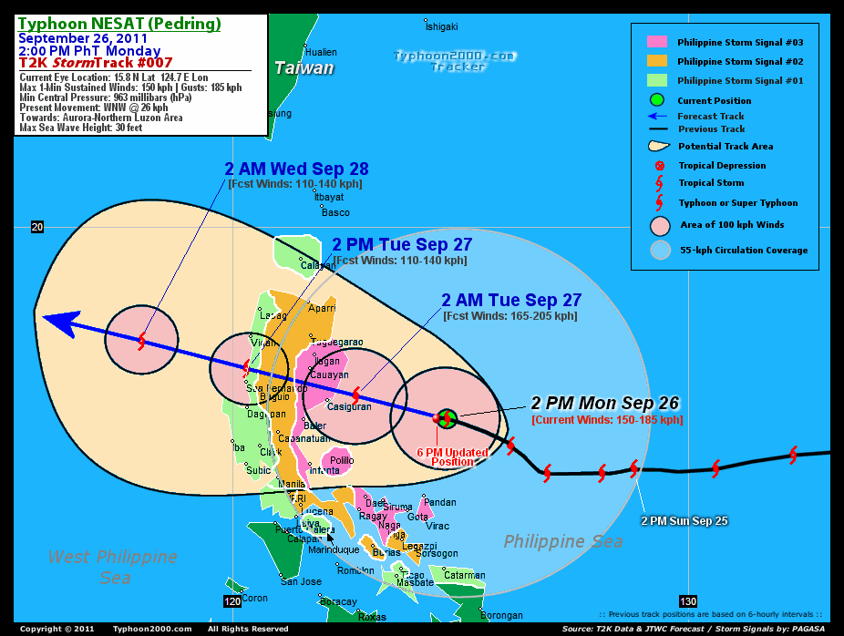
Typhoon NESAT (PEDRING) dangerously closing in to Aurora, Isabela & Quirino Provinces...inner rainbands approaching the East Coast of Luzon.
Projected Landfall Area (PLA): Northern Aurora...with possible entry point or touchdown just north of Casiguran between 4-5 AM local time Tuesday.
Residents and visitors along Luzon particularly Northern Bicol, Northern Quezon, Aurora, Quirino & Isabela should closely monitor the progress of NESAT (PEDRING).
Do not use this for life or death decision. This advisory is intended for additional information purposes only. Kindly refer to your country's official weather agency for local warnings, advisories & bulletins.
CURRENT STORM INFORMATION
Time/Date: 6:00 PM PhT Mon September 26 2011
Location of Eye: 15.8º N Lat 124.4º E Lon
Distance 1: 190 km North of Pandan, Catanduanes
Distance 2: 246 km North of Virac, Catanduanes
Distance 3: 232 km NE of Siruma, CamSur
Distance 4: 248 km NE of Daet, CamNorte
Distance 5: 260 km ESE of Casiguran, Aurora
Distance 6: 277 km NNE of Metro Naga/CWC
Distance 7: 309 km NNE of Legazpi City
Distance 8: 300 km East of Baler, Aurora
Distance 9: 313 km SE of Cauayan, Isabela
Distance 10: 378 km ENE of Metro Manila
Distance 11: 411 km ESE of Baguio City
MaxWinds (1-min avg): 150 kph (80 kts) near the center
Peak Wind Gusts: 185 kph (100 kts)
Present Movement: WNW @ 22 kph (12 kts)
Towards: Northern Aurora-Quirino-Isabela
CPA [ETA] to Aurora: Tuesday Morning [4-5am PhT]
24hr Rainfall Accum (near center): 400 mm (High)
Rainrate (near center): 15-20 mm/hr (Moderate)
Minimum Central Pressure: 963 millibars (hPa)
Saffir-Simpson Typhoon Scale: Category 1
Size (in Diameter): 905 km (490 nm) [Very Large]
Wind Area Distribution (in Knots): Current Wind Profile
Max Sea Wave Height (near center): 30 ft
Possible Storm Surge Height: 4-5 ft [1.2-1.7 m]
T2K TrackMap (for Public): 6 PM PhT Mon Sep 26
3-DAY FORECAST OUTLOOK & ANALYSIS*
NESAT (PEDRING) is expected to maintain its general WNW track troughout the forecast period with some decrease on its forward speed. On the forecast track, the center of the typhoon will pass more or less 250 km to the north of Bicol Region tonight...and make landfall over Northern Aurora or just north of Casiguran by early Tuesday morning. NESAT will then cross the southern part of Northern Luzon - passing along Northern Quirino-Southern Isabela, Nueva Vizcaya, Benguet-Ifugao...and exit through La Union Tuesday afternoon. By Wednesday through Thursday, NESAT will be over the West Philippine Sea, leaving the Philippine Area of Responsibility (PAR) as it moves towards Hainan Island, Southern China.
Maximum Sustained Winds (1-min. avg) remain near 150 km/hr (80 knots) with higher gusts. NESAT is a Category 1 Typhoon on the Saffir-Simpson Tropical Cyclone Scale. Slight strengthening is still expected before the typhoon makes landfall over Northern Aurora. This system will gradually weaken just below typhoon strength as it traverses Luzon Tuesday...and will regain typhoon status upon moving back to sea by Wednesday.
Typhoon Force Winds (118 km/hr or more) extend outward up to 55 kilometers (30 nautical miles) from the center...and Tropical Storm Force Winds (62-117 km/hr) extend outward up to 240 kilometers (130 nautical miles). NESAT is now a very large-sized tropical cyclone with a diameter of 905 kilometers (490 nautical miles). Meanwhile, land observation from the Typhoon2000.com Automated Weather Station in Naga City has been observing wind gust of 35 kph blowing from the WSW and barometer readings of 997.2 millibars. The Rainfall Accumulation over the station since 12AM is now at 173.2 mm, with average rain rate of 8 to 60 mm/hr (light to heavy).
The following is the summary of the 3-day forecast outlook on this system:
 TUESDAY AFTERNOON: Downgraded to a Tropical Storm (TS), after crossing the mountainous terrain of Northern Luzon...just along the northern shores of La Union...about 33 km North of San Fernando, La Union [2PM SEP 27: 16.9N 120.3 @ 110kph].
WEDNESDAY AFTERNOON: Regains Typhoon status as it moves across the West Philippine Sea, moving out of the Philippine Area of Responsibility (PAR)...about 496 km West of Laoag City, Ilocos Norte [2PM SEP 28: 18.2N 115.9E @ 130kph].
THURSDAY AFTERNOON: Gaining strength slightly as it approaches the northern part of Hainan Island, along the coast of Southern China...about 210 km East of Qionghai, Hainan [2PM SEP 29: 19.3 112.5E @ 140kph].
NESAT's (PEDRING) CLOSEST POINT OF APPROACH (CPA)*
AURORA: About 33 km NE of Casiguran...[ETA: 4:00-5:00 AM Local Time, Tuesday].
QUIRINO: Moving across the northern part of the province [ETA: 5:00-6:00 AM Tuesday].
BAGUIO CITY: Passing about 46 km NE of the "City of Pines" [ETA: 11:00 AM-12:00 PM Tuesday].
*Please be reminded that the Forecast Outlook changes every 6 hours, and the Day 3 Forecast Track have an average error of 250 km...while the wind speed forecast error, averages 35 kph per day. Therefore, a turn to the left or right of its future track and changes in its wind speed must be anticipated from time to time.
EFFECTS & HAZARDS SUMMARY
NESAT's (PEDRING) circulation remains very large w/ very deep rainband-convection along its bands, especially the outer bands. A large eye has started to be seen on satellite imageries. Below is the summary of the storm's parts and its hazards affecting specific areas:
CLOUD-FILLED EYE - over water (Philippine Sea)...but will reach the Northern part of Aurora early tomorrow morning. Possible calm and lull conditions (with <20 kph winds) will be expected inside the eye (click here to know more about the EYE). EYEWALL - over water (Philippine Sea)...not yet affecting any islands or major land areas...but is expected to reach the shores of Northern Aurora on or after midnight. Typhoon Conditions with Typhoon Force Winds (>118 kph) will be expected within this wall (click here to know more about the Eyewall). INNER RAINBANDS - affecting & spreading across the Northern Coast of Bicol Region & Polillo Island...and will approach the coastal areas of Northern Quezon, Aurora & Isabela tonight. Tropical Storm Conditions w/ Tropical Storm Force Winds (62-117 kph) will be expected along these bands. OUTER RAINBANDS - affecting & spreading across the whole of Luzon including Mindoro, Calamian Group, and Northern Visayas & Samar. Tropical Depression Conditions w/ moderate to strong winds (25-61 kph) will be expected along these bands (click here to know more about Rainbands). 24HR TOTAL RAINFALL ACCUMULATION - from 5 up to 250 mm (low to high rainfall) can be expected along areas affected by the outer & inner rainbands (see above)...with isolated amounts of 251 to 400 mm (high) along areas near the center of NESAT (PEDRING). (click to open NOAA's eTRaP graphic). COASTAL STORM SURGE FLOODING - possible 4-5 ft [1.2-1.7 m] above normal tide levels...accompanied by large and dangerous battering waves can be expected along the coastal and beach front areas of Eastern & Northern Bicol Region & Eastern Luzon. Minimal damage is likely on this type of storm surge. Danger from Rip Currents or Rip Tides can be expected along the beach-front areas of Luzon & Visayas. (click here to know more about Storm Surge).
TROPICAL CYCLONE WATCH
Tropical Storm HAITANG (21W) moving very slowly over the South China Sea, near Hainan. The system was located about 242 km SSE of Hainan Island (16.7N 111.2E)...maximum sustained winds of 65 kph...gusting up to 85 kph...moving WSW @ 04 kph. To view the latest information on this storm kindly click this link.
CURRENT SW MONSOON INTENSITY: MODERATE >> Mostly cloudy skies with passing occasional showers, rains or thunderstorms w/ squalls will be expected across the following affected areas: REST OF VISAYAS & PALAWAN. Light to moderate SW'ly winds (not in excess of 40 kph) will blow across the abovementioned areas.
Important Note: Please keep in mind that the above forecast outlook, effects-hazards, current monsoon intensity, & tropical cyclone watch changes every 6 to 12 hrs!![]()
PAGASA Philippine Storm Warnings Signals
PHILIPPINE STORM SIGNAL # THREE (3) 
Now In Effect: CATANDUANES, CAMARINES SUR, CAMARINES NORTE, NORTHERN QUEZON, POLILLO ISLAND, AURORA, QUIRINO, & ISABELA.
PHILIPPINE STORM WARNING SIGNAL # TWO (2)
In Effect: ALBAY, BURIAS ISLAND, REST OF QUEZON, RIZAL, BULACAN, NUEVA ECIJA, NUEVA VIZCAYA, IFUGAO, BENGUET, MOUNTAIN PROVINCE, KALINGA, CAGAYAN, & METRO MANILA.
The above areas will continue to experience stormy weather tonight until tomorrow (with winds not exceeding 100 kph for #02 and 100-185 kph for #03). Coastal waters will be rough to very rough and extremely dangerous to all types of seacrafts.
PHILIPPINE STORM WARNING SIGNAL # ONE (1)
In Effect: MASBATE, TICAO ISLAND, NORTHERN SAMAR, MARINDUQUE, BATANGAS, LAGUNA, CAVITE, PAMPANGA, BATAAN, PAMPANGA, ZAMBALES, TARLAC, PANGASINAN, LA UNION, ILOCOS SUR, ILOCOS NORTE, ABRA, APAYAO, CALAYAN, AND BABUYAN GROUP OF ISLANDS.
The above areas will have rains and winds of not more than 60 kph tonight until tomorrow. Coastal waters will be moderate to rough.
Residents living in low-lying and mountainous areas under Public Storm Warning Signals are alerted against flashfloods, mudslides and landslides...while those living in coastal & beach-front areas are advised to seek higher grounds due to possible storm surge (aka. big waves).
External Links for TY NESAT (PEDRING)
PAGASA@Twitter: Hourly Updates
View NOAA-CIRA's: Latest Full Wind Analysis
JTWC Latest Tracking Chart: wp2011.gif
Multi-Agency Forecast TrackMap: Near Real-Time
TSR Wind Probabilities: Current to 5 Days Ahead
JAXA TRMM Page: Latest Rainrate (in mm/hr)
Zoomed Satellite Pic: NOAA's Near Real-Time
Wunderground Animation: 6-12 hr. GIF Loop
TYPHOON2000 CURRENT STORMTRACK:
>> To know the meteorological terminologies and acronyms used on this update visit the ff:
http://typhoon2000.ph/tcterm.htm
http://www.nhc.noaa.gov/aboutgloss.shtml
http://www.nhc.noaa.gov/acronyms.shtml
__________________________________________________________________________________________
For the complete details on TY NESAT (PEDRING)...go visit our website @:
> http://www.typhoon2000.com
> http://www.maybagyo.com
Copyright © 2011 Typhoon2000.com All Rights Reserved

No comments:
Post a Comment