
for Sunday, 25 September 2011 [12:20 PM PhT]
![]()

<<<Typhoon2000.com Mobile >>>
Get the latest 6-hrly SMS Storm Alerts on PEDRING!
For more details: Text T2K TYPHOON to
2800 (Globe/TM) | 216 (Smart/TNT) | 2288 (Sun)
*Only P2.50 (Smart/Globe) / P2.00 (Sun) per msg received.
Click here on how to use this service (in PDF file)
Powered by: Synermaxx Corporation
Typhoon2000 (T2K) NEWS (Saturday Sep 24 2011):
Currently issuing 6-hrly web, email, & android (iTyphoon) updates (except 12:00 Midnight) on NESAT (PEDRING).
NESAT (PEDRING) MAX WIND SPEED PER AGENCY:
+ USA (JTWC/1-min avg): 120 km/hr
+ Japan (JMA/10-min avg): 95 km/hr
+ Philippines (PAGASA/10-min avg): 95 km/hr
+ Beijing (NMC/2-min avg): 95 km/hr
+ Taiwan (CWB/10-min avg): 95 km/hr
+ Korea (KMA/10-min avg): 95 km/hr
+ Hong Kong (HKO/10-min avg): 75 km/hr
:: Click here to see Multi-Agency Forecast Tracks
TYPHOON NESAT [PEDRING/20W/1117]
T2K PUBLIC ADVISORY NUMBER 008
12:00 PM PhT (04:00 GMT) Sun 25 September 2011
Source: T2K Analysis/JTWC TC Warning #007/SatFixes
View: Advisory Archives (2004-2011)
NESAT (PEDRING) now a Typhoon as it continued moving quickly westward. Its outer rainbands expected to reach Bicol Region and Eastern Visayas later today. Philippine Storm Warning Signal #1 has already been raised along parts of Bicol Region.
Projected Landfall Area (PLA): Northern Aurora & Isabela on Tuesday morning...with possible entry point just north of Casiguran.
Residents and visitors along Luzon particularly Aurora, Cagayan & Isabela should closely monitor the progress of NESAT (PEDRING).
Do not use this for life or death decision. This advisory is intended for additional information purposes only. Kindly refer to your country's official weather agency for local warnings, advisories & bulletins.
CURRENT STORM INFORMATION
Time/Date: 12:00 PM PhT Sun September 25 2011
Location of Eye: 14.7º N Lat 129.5º E Lon
Distance 1: 575 km ENE of Pandan, Catanduanes
Distance 2: 584 km ENE of Virac, Catanduanes
Distance 3: 651 km ENE of Legazpi City
Distance 4: 690 km ENE of Metro Naga/CWC
Distance 5: 810 km ESE of Casiguran, Aurora
Distance 6: 839 km East of Infanta, Quezon
Distance 7: 914 km East of Metro Manila
MaxWinds (1-min avg): 120 kph (65 kts) near the center
Peak Wind Gusts: 150 kph (80 kts)
Present Movement: West @ 31 kph (17 kts)
Towards: Northern Luzon
CPA [ETA] to N.Aurora-Isabela: Tuesday Morning [7-9am PhT]
24hr Rainfall Accum (near center): 330 mm (High)
Rainrate (near center): 10-15 mm/hr (Moderate)
Minimum Central Pressure: 974 millibars (hPa)
Saffir-Simpson Typhoon Scale: Category 1
Size (in Diameter): 555 km (300 nm) [Average]
Wind Area Distribution (in Knots): Current Wind Profile
Max Sea Wave Height (near center): 16 ft
Possible Storm Surge Height: 4-5 ft [1.2-1.7 m]
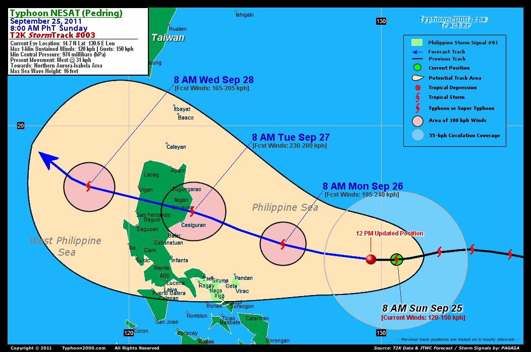
T2K TrackMap (for Public): 12 PM PhT Sun Sep 25
3-DAY FORECAST OUTLOOK & ANALYSIS*
NESAT (PEDRING) is expected to continue moving on a straight-Westerly motion during the next 12 hours...then turning WNW-ward with some decrease in forward speed is likely within the forecast period. On the forecast track, the center of the typhoon will be approaching the east coast of Northern Aurora & Isabela Monday night...and making landfall NNE of the the town of Casiguran by Tuesday morning. NESAT will then traverse Northern Luzon, cutting across Southern Isabela, Cordilleras Tuesday afternoon...and exit the area through Ilocos Sur by early Wednesday.
Maximum Sustained Winds (1-min. avg) have increased to near 120 km/hr (65 knots) with higher gusts. NESAT is a Category 1 Typhoon on the Saffir-Simpson Tropical Cyclone Scale. Gradual strengthening will continue during the next couple of days...and NESAT could become a Category 4 Typhoon before it makes landfall Tuesday.
Typhoon Force Winds (118 km/hr or more) extend outward up to 20 kilometers (10 nautical miles) from the center...and Tropical Storm Force Winds (62-117 km/hr) extend outward up to 150 kilometers (80 nautical miles). NESAT remains an average-sized tropical cyclone with a diameter of 555 kilometers (300 nautical miles). Possible continued increase in its circulation size is likely as the system moves into the warm Philippine Sea in the next couple of days.
The following is the summary of the 3-day forecast outlook on this system:
 MONDAY MORNING: Turns WNW while passing well to the NE of Bicol Region...upgraded to a Category 3 Typhoon...about 244 km NE of Pandan, Catanduanes, PH [8AM SEP 26: 15.3N 126.1 @ 195kph].
TUESDAY MORNING: Making landfall along Northern Aurora-Isabela Area...almost a Super Typhoon (Category 4)...about 62 km NE of Casiguran, Aurora, PH [8AM SEP 27: 16.6N 122.5E @ 230kph].
WEDNESDAY MORNING: Weakens to a Category 2 typhoon after crossing Northern Luzon...in the vicinity of the West Philippine Sea (aka. South China Sea)...about 212 km East of Vigan City, Ilocos Sur, PH [8AM SEP 28: 17.6 118.4E @ 165kph].
**Alternate Forecast Scenario (AFS): There is a possibility that NESAT (PEDRING) will continue moving Westward and make landfall over Aurora Province instead...cutting across the Northern Part of Central Luzon...and exiting along the Benguet-La Union Area. This scenario may happen if the High Pressure Steering Ridge northeast of the typhoon will not weaken & extends westward.
NESAT's (PEDRING) CLOSEST POINT OF APPROACH (CPA)*
NORTHERN AURORA: Just to the NNE of Casiguran...[ETA: 8:00-9:00 AM Local Time, Tuesday].
SOUTHERN ISABELA: Passing very close to the south Cauayan City [ETA: 12:00-1:00 PM Tuesday].
*Please be reminded that the Forecast Outlook changes every 6 hours, and the Day 3 Forecast Track have an average error of 250 km...while the wind speed forecast error, averages 35 kph per day. Therefore, a turn to the left or right of its future track and changes in its wind speed must be anticipated from time to time.
EFFECTS & HAZARDS SUMMARY
NESAT's (PEDRING) circulation continues to expand & become better organized w/ very deep rainband-convection with an eye forming over the center. Below is the summary of the storm's parts and its hazards affecting specific areas:
CLOUD-FILLED EYE - over water (Philippine Sea). Possible calm and lull conditions (with <20 kph winds) will be expected inside the eye (click here to know more about the EYE). EYEWALL - over water (Philippine Sea)...not yet affecting any islands or major land areas. Typhoon Conditions with Typhoon Force Winds (>118 kph) will be expected within this wall (click here to know more about the Eyewall). INNER RAINBANDS - over water (Philippine Sea)...not yet affecting any islands or major land areas. Tropical Storm Conditions w/ Tropical Storm Force Winds (62-117 kph) will be expected along these bands. OUTER RAINBANDS - over water (Philippine Sea)...not yet affecting any islands or major land areas. however its western outer rainbands will reach Bicol Region & Eastern Visayas tonight. Tropical Depression Conditions w/ moderate to strong winds (25-61 kph) will be expected along these bands (click here to know more about Rainbands). 24HR TOTAL RAINFALL ACCUMULATION - from 5 up to 300 mm (low to high rainfall) can be expected along areas affected by the outer & inner rainbands (see above)...with isolated amounts of 101 to 330 mm (high) along areas near the center of NESAT (PEDRING). (click to open NOAA's eTRaP graphic).
TROPICAL CYCLONE WATCH
Tropical Depression HAITANG (21W) drifting NE over the South China Sea. The system was located about 349 km ESE of Da Nang, Vietnam (16.0N 113.2E)...maximum sustained winds of 55 kph...gusting up to 75 kph...drifting slowly NE-ward. To view the latest information on this storm kindly click this link.
CURRENT SW MONSOON INTENSITY: MODERATE >> Mostly cloudy skies with passing occasional showers, rains or thunderstorms w/ squalls will be expected across the following affected areas: portions of MINDANAO & VISAYAS. Light to moderate SW'ly winds (not in excess of 35 kph) will blow across the abovementioned areas.
Important Note: Please keep in mind that the above forecast outlook, effects-hazards, current monsoon intensity, & tropical cyclone watch changes every 6 to 12 hrs!![]()
PAGASA Philippine Storm Warnings Signals
PHILIPPINE STORM WARNING SIGNAL # ONE (1) 
Now In Effect: CATANDUANES, ALBAY & CAMARINES SUR.
The above areas will have rains and winds of not more than 60 kph beginning tonight. Coastal waters will be moderate to rough.
Residents living in low-lying and mountainous areas under Public Storm Warning Signals are alerted against flashfloods, mudslides and landslides...while those living in coastal & beach-front areas are advised to seek higher grounds due to possible storm surge (aka. big waves).
External Links for TY NESAT (PEDRING)
PAGASA@Twitter: Hourly Updates
View NOAA-CIRA's: Latest Full Wind Analysis
JTWC Latest Tracking Chart: wp2011.gif
Multi-Agency Forecast TrackMap: Near Real-Time
TSR Wind Probabilities: Current to 5 Days Ahead
JAXA TRMM Page: Latest Rainrate (in mm/hr)
Zoomed Satellite Pic: NOAA's Near Real-Time
Wunderground Animation: 6-12 hr. GIF Loop
TYPHOON2000 CURRENT STORMTRACK:
>> To know the meteorological terminologies and acronyms used on this update visit the ff:
http://typhoon2000.ph/tcterm.htm
http://www.nhc.noaa.gov/aboutgloss.shtml
http://www.nhc.noaa.gov/acronyms.shtml
__________________________________________________________________________________________
For the complete details on TS NESAT (PEDRING)...go visit our website @:
> http://www.typhoon2000.com
> http://www.maybagyo.com
Copyright © 2011 Typhoon2000.com All Rights Reserved

No comments:
Post a Comment