
for Friday, 30 September 2011 [6:30 AM PhT]
![]()

<<<Typhoon2000.com Mobile >>>
Get the latest 6-hrly SMS Storm Alerts on QUIEL!
For more details: Text T2K TYPHOON to
2800 (Globe/TM) | 216 (Smart/TNT) | 2288 (Sun)
*Only P2.50 (Smart/Globe) / P2.00 (Sun) per msg received.
Click here on how to use this service (in PDF file)
Powered by: Synermaxx Corporation
Typhoon2000 (T2K) NEWS (Wednesday Sep 28 2011):
Currently issuing 6-hrly web, email, & android (iTyphoon) updates (except 12:00 Midnight) on NALGAE (QUIEL).
NALGAE (QUIEL) MAX WIND SPEED PER AGENCY:
+ USA (JTWC/1-min avg): 150 km/hr
+ Japan (JMA/10-min avg): 150 km/hr
+ Philippines (PAGASA/10-min avg): 130 km/hr
+ Beijing (NMC/2-min avg): 125 km/hr
+ Taiwan (CWB/10-min avg): 145 km/hr
+ Korea (KMA/10-min avg): 150 km/hr
+ Hong Kong (HKO/10-min avg): 105 km/hr
:: Click here to see Multi-Agency Forecast Tracks
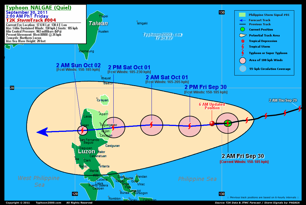
TYPHOON NALGAE [QUIEL/22W/1119]
T2K PUBLIC ADVISORY NUMBER 004
6:00 AM PhT (22:00 GMT) Fri 30 September 2011
Source: T2K Analysis/JTWC TC Warning #011/SatFixes
View: Advisory Archives (2004-2011)
Typhoon NALGAE (QUIEL) intensifying over the Philippine Sea as it maintains its westerly to a slight WSW motion...now endangers Northern Luzon. Landfall is now expected along Palanan-Divilacan Bay in less than 36 hours.
Projected Landfall Area (PLA): Isabela...passing over/near Divilacan-Palanan Bay at approx 2-4 PM local time Saturday.
Residents and visitors along Northern Luzon should closely monitor the progress of NALGAE (QUIEL).
Do not use this for life or death decision. This advisory is intended for additional information purposes only. Kindly refer to your country's official weather agency for local warnings, advisories & bulletins.
CURRENT STORM INFORMATION
Time/Date: 6:00 AM PhT Fri September 30 2011
Location of Eye: 17.6º N Lat 129.2º E Lon
Distance 1: 795 km East of Tuguegarao City
Distance 2: 786 km ENE of Ilagan City
Distance 3: 800 km ENE of Cauayan, Isabela
Distance 4: 808 km ESE of Aparri, Cagayan
Distance 5: 771 km ENE of Casiguran, Aurora
Distance 6: 912 km ESE of Laoag City
Distance 7: 932 km East of Vigan City
Distance 8: 937 km ENE of Metro Manila
MaxWinds (1-min avg): 150 kph (80 kts) near the center
Peak Wind Gusts: 185 kph (100 kts)
Present Movement: WEST-WSW @ 24 kph (13 kts)
Towards: Northern Luzon
24hr Rainfall Accum (near center): 200 mm (High)
Rainrate (near center): 15-20 mm/hr (Light-Mod)
Minimum Central Pressure: 963 millibars (hPa)
Saffir-Simpson Typhoon Scale: Category 1
Size (in Diameter): 500 km (270 nm) [Average]
Wind Area Distribution (in Knots): Current Wind Profile
Max Sea Wave Height (near center): 20 ft
Possible Storm Surge Height: 4-5 ft [1.2-1.7 m]
T2K TrackMap (for Public): 6 AM PhT Fri Sep 30
3-DAY FORECAST OUTLOOK & ANALYSIS*
NALGAE (QUIEL) will continue to move generally westward (known in meteorology as a "Straight-Runner") w/ a slight dig to the south throughout the forecast period...little change in its forward speed in anticipated. On the forecast track, the core of the typhoon will make landfall along Palanan-Divilacan Bay in Isabela Saturday afternoon...and cross Northern Luzon through the evening...passing over the same provinces being previously hit by NESAT (PEDRING). NALGAE will move out of Northern Luzon via La Union-Ilocos Sur Area Sunday early morning...and will be over the West Philippine Sea (South China Sea) Sunday afternoon through Monday.
Maximum Sustained Winds (1-min. avg) have increased to near 150 km/hr (80 knots) with higher gusts. Additional strengthening is forecast during the next 36 hours, prior in making landfall over Northern Luzon...and NALGAE could become a Category 3 Typhoon Saturday noon. This cyclone is a Category 1 Typhoon on the Saffir-Simpson Tropical Cyclone Scale.
Typhoon Force Winds (118 km/hr or more) extend outward up to 45 kilometers (20 nautical miles) from the center...and Tropical Storm Force Winds (62-117 km/hr) extend outward up to 165 kilometers (90 nautical miles). NALGAE is an average-sized tropical cyclone with a diameter of 500 kilometers (270 nautical miles).
The following is the summary of the 3-day forecast outlook on this system:
 SATURDAY EARLY MORNING: Intensifies into a Category 2 Typhoon...approaching the shores of Isabela-Southern Cagayan [2AM OCT 01: 17.5N 125.2E @ 165kph].
SUNDAY EARLY MORNING: Just along the coast of La Union-Ilocos Sur...weakens rapidly after crossing Northern Luzon [2AM OCT 02: 17.1N 120.5E @ 150kph].
MONDAY EARLY MORNING: In the middle of the West Philippine Sea (South China Sea)...leaves the Philippine Area of Responsibility (PAR) [2AM OCT 03: 17.2N 115.7E @ 130kph].
NALGAE's (QUIEL) CLOSEST POINT OF APPROACH (CPA)*
EASTERN ISABELA: Passing over/near Divilacan-Palanan Bay...[ETA: 2:00-4:00 PM Local Time, Saturday].
*Please be reminded that the Forecast Outlook changes every 6 hours, and the Day 3 Forecast Track have an average error of 250 km...while the wind speed forecast error, averages 35 kph per day. Therefore, a turn to the left or right of its future track and changes in its wind speed must be anticipated from time to time.
EFFECTS & HAZARDS SUMMARY
NALGAE's (QUIEL's) compact circulation improving with a possible small eye. Below is the summary of the storm's parts and its hazards affecting specific areas:
SMALL, CLOUD-FILLED EYE - over water (North Philippine Sea). Possible calm and lull conditions (with <20 kph winds) will be expected inside the eye (click here to know more about the EYE). EYEWALL - over water (West Philippine Sea). Typhoon Conditions with Typhoon Force Winds (>118 kph) will be expected within this wall (click here to know more about the Eyewall). INNER RAINBANDS - over water (North Philippine Sea)...not yet affecting any land areas.. Tropical Storm Conditions w/ Tropical Storm Force Winds (62-117 kph) will be expected along these bands. OUTER RAINBANDS - over water (North Philippine Sea)...not yet affecting any land areas...however its western outer rainbands will reach Cagayan, Isabela & Northern Aurora on Saturday. Tropical Depression Conditions w/ moderate to strong winds (25-61 kph) will be expected along these bands (click here to know more about Rainbands). 24HR TOTAL RAINFALL ACCUMULATION - from 5 up to 100 mm (low to high rainfall) can be expected along areas affected by the outer & inner rainbands (see above)...with isolated amounts of 101 to 200 mm (high) along areas near the center of NALGAE (QUIEL). (click to open NOAA's eTRaP graphic). COASTAL STORM SURGE FLOODING - possible 4-5 ft [1.2-1.7 m] above normal tide levels...accompanied by large and dangerous battering waves can be expected along the coastal and beach front areas of Northeastern Luzon beginning Saturday. Minimal damage is likely on this type of storm surge. Danger from Rip Currents or Rip Tides can be expected along the beach-front areas of Luzon & Visayas. (click here to know more about Storm Surge).
TROPICAL CYCLONE WATCH
Tropical Disturbance 90W (LPA) tagging along to the south of NALGAE...near Palau...east of Mindanao. Its weak center was located about 1170 km ESE of Surigao City (8.0N 136.0E)...maximum sustained winds of 30 kph and remains almost stationary. The 24-hour TC Formation Potential is LOW (20%).
Important Note: Please keep in mind that the above forecast outlook, effects-hazards, current monsoon intensity, & tropical cyclone watch changes every 6 to 12 hrs!![]()
PAGASA Philippine Storm Warnings Signals
PHILIPPINE STORM WARNING SIGNAL # ONE (1) 
Now In Effect: CAGAYAN, ISABELA & BABUYAN GROUP OF ISLANDS.
The above areas will have rains and winds of not more than 60 kph beginning tomorrow. Coastal waters will be moderate to rough.
Residents living in low-lying and mountainous areas under Public Storm Warning Signals are alerted against flashfloods, mudslides and landslides...while those living in coastal & beach-front areas are advised to seek higher grounds due to possible storm surge (aka. big waves).
External Links for TY NALGAE (QUIEL)
PAGASA@Twitter: Hourly Updates
View NOAA-CIRA's: Latest Full Wind Analysis
JTWC Latest Tracking Chart: wp2211.gif
Multi-Agency Forecast TrackMap: Near Real-Time
TSR Wind Probabilities: Current to 5 Days Ahead
JAXA TRMM Page: Latest Rainrate (in mm/hr)
Zoomed Satellite Pic: NOAA's Near Real-Time
Wunderground Animation: 6-12 hr. GIF Loop
TYPHOON2000 CURRENT STORMTRACK:
>> To know the meteorological terminologies and acronyms used on this update visit the ff:
http://typhoon2000.ph/tcterm.htm
http://www.nhc.noaa.gov/aboutgloss.shtml
http://www.nhc.noaa.gov/acronyms.shtml
__________________________________________________________________________________________
For the complete details on TY NALGAE (QUIEL)...go visit our website @:
> http://www.typhoon2000.com
> http://www.maybagyo.com
Copyright © 2011 Typhoon2000.com All Rights Reserved

No comments:
Post a Comment