
for Sunday, 19 June 2011 [6:45 PM PhT]![]()

<<<Typhoon2000.com Mobile >>>
Get the latest 3-hrly SMS Storm Alerts on EGAY!
For more details: Text T2K HELP to
2800 (Globe/TM) | 216 (Smart/TNT) | 2288 (Sun)
*Only P2.50 (Smart/Globe) / P2.00 (Sun) per msg received.
Click here on how to use this service (in PDF file)
Powered by: Synermaxx Corporation
Typhoon2000 (T2K) NEWS (Saturday June 18 2011):
Currently issuing 3-hrly web, twitter and e-mail updates (except 12:00 Midnight) on TS 06W (EGAY).
06W (EGAY) MAX WIND SPEED PER AGENCY:
+ USA (JTWC/1-min avg): 65 km/hr
+ Japan (JMA/10-min avg): 55 km/hr
+ Philippines (PAGASA/10-min avg): 55 km/hr
TROPICAL STORM 06W [EGAY]
T2K PUBLIC ADVISORY NUMBER 011
6:00 PM PhT (10:00 GMT) Sun 19 June 2011
Sources: T2K Extrap Analysis/JTWC Warning #011/SatFixes
View: Advisory Archives (2004-2011)
Tropical Storm 06W (EGAY) inching closer towards the northern tip of Cagayan. Enhanced Monsoon rains across Metro Manila, Luzon and Visayas including Bicol Region, Palawan, Marinduque, Romblon & Mindoro.
Residents and visitors along Extreme Northern Luzon & Southeastern-Southern China should closely monitor the progress of 06W (EGAY).
Do not use this for life or death decision. This advisory is intended for additional information purposes only. Kindly refer to your country's official weather agency for local warnings, advisories & bulletins.
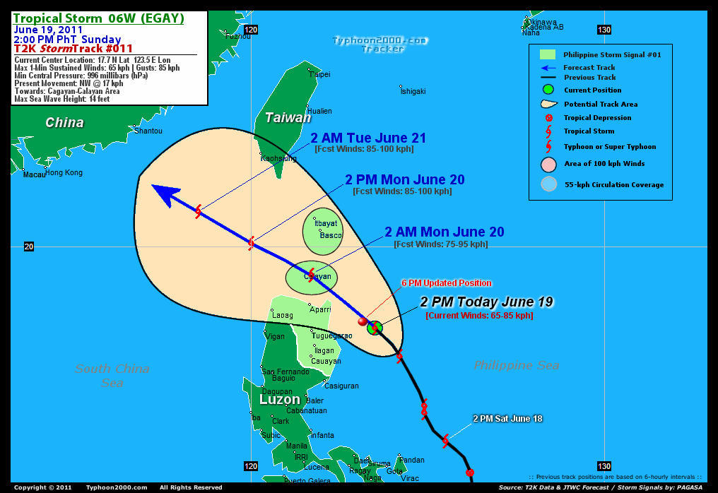
CURRENT STORM INFORMATION
Time/Date: 6:00 PM PhT Sun June 19 2011
Location of Center: 17.9º N Lat 123.2º E Lon
Distance 1: 160 km (88 nm) ENE of Tuguegarao City
Distance 2: 170 km (93 nm) NE of Ilagan City
Distance 3: 170 km (93 nm) ESE of Aparri, Cagayan
Distance 4: 235 km (127 nm) SE of Calayan Island
Distance 5: 275 km (148 nm) ESE of Laoag City
Distance 6: 315 km (170 nm) SSE of Basco, Batanes
Distance 7: 435 km (235 nm) NNE of Metro Manila
MaxWinds (1-min avg): 65 kph (35 kts) near the center
Peak Wind Gusts: 85 kph (45 kts)
Present Movement: NW @ 17 kph (09 kts)
Towards: Cagayan-Calayan Area
CPA [ETA] to N.Cagayan: Tonight [8-11PM PhT]
24hr Rainfall Accum (near center): 350 mm (High)
Rainrate (near center): 20-25 mm/hr (Mod)
Minimum Central Pressure: 996 millibars (hPa)
Saffir-Simpson Typhoon Scale: TS
Size (in Diameter): --- km (--- nm) / N/A
Wind Area Distribution (in Knots): Current Wind Profile
Max Sea Wave Height (near center): 14 ft (4.2 m)
Possible Storm Surge Height: 0 ft [0 m]
T2K TrackMap (for Public): 6:00 PM PhT Sun June 19
FORECAST OUTLOOK ANALYSIS (up to 2 days)* 06W's CLOSEST POINT OF APPROACH (CPA)* EXTENDED FORECAST TRACK (3 to 4 days)* EFFECTS & HAZARDS SUMMARY TROPICAL CYCLONE WATCH CURRENT SW MONSOON INTENSITY: STRONG >> Mostly cloudy with widespread moderate to heavy on-&-off rains w/ squalls & thunderstorms will be expected along the following affected areas: SULU SEA, SOUTHERN & WESTERN LUZON incl. METRO MANILA, VISAYAS, PALAWAN, CALAMIAN GROUP, MINDORO, MARINDUQUE, ROMBLON, BICOL REGION incl. MASBATE. Light to moderate SW'ly winds (not in excess of 40 kph) will blow. Important Note: Please keep in mind that the above forecast outlook, extended forecast, effects-hazards, current monsoon intensity, & tropical cyclone watch changes every 6 to 12 hrs! PHILIPPINE STORM WARNING SIGNAL # ONE (1) The above areas will have rains and winds of not more than 60 kph today. Coastal waters will be moderate to rough.
06W (EGAY) is expected to intensify slowly as it turns more NW'ly within the next 24-48 hours, passing close to the north of Cagayan tonight, and across the Calayan Island in the Balintang Channel early tomorrow morning - before moving out into the South China Sea tomorrow afternoon. It will be approaching the coast of Southern China by Tuesday afternoon.  TOMORROW EARLY MORNING (MON): Gaining strength slightly as it traverses the waters of the Balintang Channel...about 25 km SE of Calayan Is., Cagayan, PH [2AM JUN 20: 19.2N 121.7E @ 75kph]. TOMORROW AFTERNOON (MON): Moving into the South China Sea away from the Balintang Channel...still gaining strength...about 215 km WSW of Basco, Batanes, PH [2PM JUN 20: 20.1N 120.0E @ 85kph]. TUESDAY EARLY MORNING: Entering the Northern part of the South China Sea...about 325 km SE of Shantou City, China [2AM JUN 21: 21.0N 118.5E @ 85kph]. TUESDAY AFTERNOON: Approaching the coast of Southern China...weakens slightly...about 180 km SSE of Shantou City, Fujian, China [2PM JUN 21: 21.9N 117.3E @ 75kph].
Maximum Sustained Winds (1-min. avg) are near 65 km/hr (35 knots) with higher gusts. 06W (EGAY) is a Tropical Storm (TS) on the Saffir-Simpson Tropical Cyclone Scale. NORTHERN CAGAYAN: About 70 km ENE of Aparri, Cagayan or 30 km NNE of Escaparda Point [ETA: between 8:00-11:00 PM Tonight]. WEDNESDAY AFTERNOON: Making landfall over Eastern Guangdong, Southern China...downgraded to a Tropical Depression (TD) [2PM JUNE 22: 23.1N 115.7E @ 55kph]. THURSDAY AFTERNOON: Dissipating over mainland China, just an area of low pressure [2PM JUNE 23: 24.3N 114.9E @ 20kph].
*Please be reminded that the Forecast Outlook changes every 6 hours, and the Extended Forecast Track have an average error of 250 km on Day 3...450 km on Day 4...and 650 km on Day 5, while the wind speed forecast error, averages 35 kph per day. Therefore, a turn to the left or right of its future track and changes in its wind speed must be anticipated from time to time.
06W's (EGAY) circulation still sheared with the low-level circulation center (LLCC) not aligned with the rain-cloud convection. Below are the summary of the depression's parts and its hazards affecting specific areas: DEVELOPING INNER RAINBANDS - still over water (Philippine Sea)...not affecting any land areas. Tropical Storm Conditions w/ Tropical Storm Force Winds (65-85 kph) can be expected along these bands. OUTER RAINBANDS - affecting & spreading across Northern & Central Luzon. Tropical Depression Conditions w/ moderate to strong winds (30-61 kph) can be expected along these bands (click here to know more about Rainbands). 12-18HR TOTAL RAINFALL ACCUMULATION - from 5 up to 100 mm (low to medium rainfall) can be expected along the outer & inner rainbands...with isolated amounts of up to 350 mm (medium) near the center of 06W (EGAY) or along Extreme Northern Luzon from Ilocos Norte up to Cagayan. (click to open NOAA's eTRaP graphic).
Tropical Disturbance 99W (LPA/1007 MB) over the Caroline Islands, SW of Guam is now increasing in its organization. Its possible center was located near lat 6.5N lon 139.3E...about 1405 km ESE of Mindanao, PH...with 1-min maximum sustained winds of 30 kph near the center...drifting West slowly. The 24-Hr. Tropical Cyclone Formation Potential on this system is now @ 40% [Medium]. View the latest satellite flash loop on this disturbance. ![]()
PAGASA Philippine Storm Warnings Signals

In Effect: AURORA, CAGAYAN, ISABELA, QUIRINO, NUEVA VIZCAYA, CALAYAN-BABUYAN IS., IFUGAO, MT. PROVINCE, KALINGA, ABRA, APAYAO & ILOCOS NORTE.
Residents living in low-lying and mountainous areas under Public Storm Warning Signal Number 1 are alerted against flashfloods, mudslides and landslides.
JTWC (US NAVY & AIR FORCE) REMARKS:
REMARKS (for Meteorologists): 2 PM (06 GMT) SUN 19 JUNE POSITION: 17.7N 123.5E.
*TROPICAL STORM (TS) 06W, LOCATED APPROXIMATELY 230 NM NORTHEAST OF
MANILA, PHILIPPINES, HAS TRACKED NORTHWEST AT 10 KNOTS DURING THE
PAST SIX HOURS. ANIMATED MULTISPECTRAL SATELLITE IMAGERY (MSI)
REVEALS A PARTIALLY EXPOSED LOW LEVEL CIRCULATION CENTER (LLCC) WITH
THE MAJORITY OF CONVECTION BEING SHEARED TO THE WEST. DESPITE
TRACKING THROUGH 31 DEGREE SEA WATER, TS 06W CONTINUES TO STRUGGLE
TO SUSTAIN VIGOROUS CONVECTION OR CONSOLIDATE AROUND THE LLCC. THE
CURRENT INTENSITY ANALYSIS IS BASED ON A COMBINATION OF SUBJECTIVE
AND AUTOMATED DVORAK ESTIMATES, AS WELL AS EXTRAPOLATIONS FROM
SURFACE REPORTS ALONG THE NORTHEAST COAST OF LUZON. A 190057Z ASCAT
IMAGE SHOWS THE STRONGEST WINDS ASSOCIATED WITH THE SYSTEM ARE IN
THE NORTHEASTERN QUADRANT. ANIMATED INFRARED SATELLITE IMAGERY AND A
190512Z AMSRE MICROWAVE IMAGE REVEAL THAT THE ONLY DEEP CONVECTION
ASSOCIATED WITH THE SYSTEM IS BEING GENERATED BY LAND INTERACTION.
THE SYSTEM IS NOT OF SUFFICIENT INTENSITY TO SUSTAIN SIGNIFICANT
DEEP CONVECTION OVER WATER. VERTICAL WIND SHEAR (VWS) IS ESTIMATED
AT 20 KNOTS. POLEWARD OUTFLOW IS BEING SUPPRESSED OVER THE NORTHEAST
QUADRANT DUE TO AN EXTENSIVE TROPICAL UPPER TROPOSPHERIC TROUGH
(TUTT) EXTENDING ALONG THE 20TH LATITUDE. SUBSIDENCE ASSOCIATED WITH
THE TUTT IS OVERRIDING THE EFFECTS OF EXTREMELY WARM SEA SURFACE
TEMPERATURES. DURING THE NEXT 24 HOURS, TS 06W WILL TRACK OVER THE
BUBAYAN ISLANDS AND REACH PEAK INTENSITY AS SEA WATERS REMAIN WARM
AND VWS RELAXES. AFTER TAU 36, WHEN THE SYSTEM MOVES INTO THE
WESTERN PASSAGES OF THE LUZON STRAIT, NORTHEASTERLY VWS WILL BEGIN
TO WEAKEN THE SYSTEM WELL BEFORE IT REACHES LANDFALL OVER
SOUTHEASTERN CHINA. MODEL GUIDANCE CONTINUES TO FLIP-FLOP AS IT
STRUGGLES TO HANDLE THE STEERING MECHANISMS, BUT DURING THE PAST 24
HOURS THERE HAS BEEN AN OVERALL TREND TOWARD MOVING THE LONG RANGE
TRACK FURTHER AWAY FROM TAIWAN AND CLOSER TO HONG KONG. THE CURRENT
FORECAST STAYS JUST WEST OF CONSENSUS IN ANTICIPATION THAT THE
DOMINANT STEERING INFLUENCE WILL BE THE SEASONAL ANTICYCLONE OVER
EASTERN CHINA. THE INTENSITY FORECAST HAS BEEN REDUCED DUE TO THE
FAILURE OF TS 06W TO INTENSIFY OVER THE NORMALLY IDEAL CONDITIONS OF
THE PHILIPPINE SEA...(more)
_______________________________________________________________________________________________________________________________________
RECENT TYPHOON2000.COM TRACKING CHART:
_________________________________________________________________________________________________________________
RECENT MULTI-AGENCY TROPICAL CYCLONE FORECAST TRACKING CHART:
**N/A**

> Image source: NOAA SATELLITE CENTER: http://www.ssd.noaa.gov/mtsat/flt/t1/rgb.jpg
> Image source: Wunderground.com Tropical Page (http://www.wunderground.com/tropical)
____________________________________________________________________________________________________________________
LATEST 24 HR. TOTAL RAINFALL AMOUNTS / ENSEMBLE TROPICAL RAINFALL POTENTIAL (eTRaP):

> Image source: NOAA Satellite & Information Service (http://www.ssd.noaa.gov/PS/TROP/etrap.html)
>> To know the meteorological terminologies and acronyms used on this update visit the ff:
http://typhoon2000.ph/tcterm.htm
http://www.nhc.noaa.gov/aboutgloss.shtml
http://www.srh.noaa.gov/oun/severewx/glossary.php
http://www.srh.weather.gov/fwd/glossarynation.html
http://www.nhc.noaa.gov/acronyms.shtml
__________________________________________________________________________________________
For the complete details on TS 06W (EGAY)...go visit our website @:
> http://www.typhoon2000.com
> http://www.maybagyo.com
Copyright © 2011 Typhoon2000.com All Rights Reserved

No comments:
Post a Comment