
for Thursday, 26 May 2011 [12:03 PM PhT]![]()

<<<Typhoon2000.com Mobile >>>
Get the latest 3-hrly SMS Storm Alerts on CHEDENG!
For more details: Text T2K TYPHOON to
2800 (Globe/TM) | 216 (Smart/TNT) | 2288 (Sun)
*Only P2.50 (Smart/Globe) / P2.00 (Sun) per msg received.
Click here on how to use this service (in PDF file)
Powered by: Synermaxx Corporation
Typhoon2000 (T2K) NEWS (Thursday May 26 2011):
Currently issuing 3-hrly web, twitter, SMS and e-mail updates on TY SONGDA (CHEDENG).
SONGDA (CHEDENG) MAX WIND SPEED PER AGENCY:
+ USA (JTWC/1-min avg): 215 km/hr
+ Philippines (PAGASA/10-min avg): 170 km/hr
+ Japan (JMA/10-min avg): 175 km/hr
+ Korea (KMA/10-min avg): 165 km/hr
+ Taiwan (CWB/10-min avg): 185 km/hr
+ Beijing (NMC/2-min avg): 190 km/hr
+ Hong Kong (HKO/10-min avg): 175 km/hr
:: Click here to see Multi-Agency Forecast Tracks
TYPHOON SONGDA [CHEDENG/04W/1102]
T2K PUBLIC ADVISORY NUMBER 021
12:00 PM PhT (04:00 GMT) Thu 26 May 2011
Sources: T2K Extrap Analysis/JTWC Warning #024/SatFixes
View: Advisory Archives (2004-2011)
Typhoon SONGDA (CHEDENG) accelerating towards the NNE with no change in strength. Outer bands bringing light to moderate rains across Bicol Region, Masbate, Southern Quezon, Polillo Islands, & Samar.
Residents and visitors along the Eastern Luzon, Bicol Region & Eastern Visayas should closely monitor the progress of SONGDA (CHEDENG).
Do not use this for life or death decision. This advisory is intended for additional information purposes only. Kindly refer to your country's official weather agency for local warnings, advisories & bulletins.
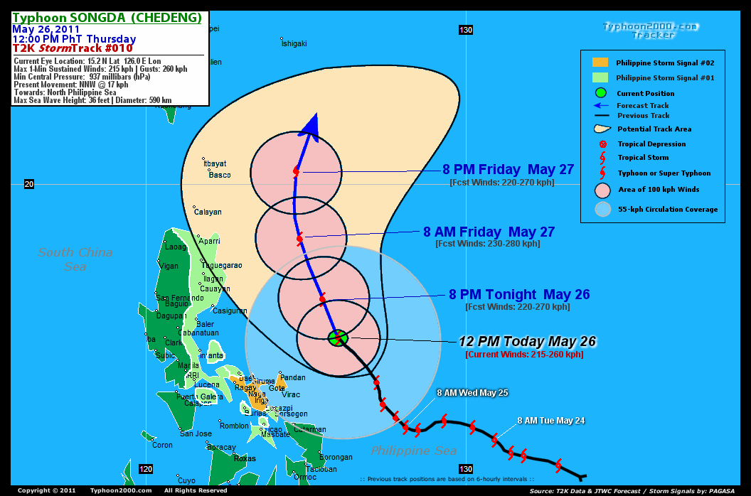
CURRENT STORM INFORMATION
Time/Date: 12:00 PM PhT Thu May 26 2011
Location of Eye: 15.2º N Lat 126.0º E Lon
Distance 1: 230 km (125 nm) NE of Pandan, Catanduanes
Distance 2: 265 km (143 nm) NE of Virac, Catanduanes
Distance 3: 340 km (183 nm) NE of Legazpi City
Distance 4: 350 km (190 nm) ENE of Metro Naga/CWC
Distance 5: 430 km (232 nm) ESE of Casiguran, Aurora
Distance 6: 530 km (285 nm) ENE of Metro Manila
MaxWinds (1-min avg): 215 kph (115 kts) near the center
Peak Wind Gusts: 260 kph (140 kts)
Present Movement: NNW @ 17 kph (09 kts)
Towards: North Philippine Sea
24hr Rainfall Accum (near center): 350 mm (High)
Rainrate (near center): 25-30 mm/hr (Mod-Heavy)
Minimum Central Pressure: 937 millibars (hPa)
Saffir-Simpson Typhoon Scale: Category 4
Size (in Diameter): 590 km (320 nm) / Average
Max Sea Wave Height (near center): 35 ft (10.6 m)
Possible Storm Surge Height: 13-18 ft [4-5.5 m]
T2K TrackMap (for Public): 9:00 AM PhT Thu May 26
FORECAST OUTLOOK ANALYSIS (up to 2 days)* EXTENDED FORECAST TRACK (3 to 5 days)*
SONGDA (CHEDENG) is expected to continue intensifying for the next 24 hours before reaching its peak strength. It will then maintain its NW to NNW track before recurving NNE-ward towards Okinawa-Ryukyu Islands on Day 2. Based on its potential track, SONGDA will just brush the eastern coast of Luzon through its Western Outer Rainbands between today until tomorrow. THIS EVENING (THU): Gaining more strength while over the Philippine Sea...passing just to the east of Aurora & Isabela...about 365 km ENE of Casiguran, Aurora [8PM MAY 26: 16.4N 125.5E @ 220kph]. TOMORROW MORNING (FRI): Shall reach peak intensity of 230 kph (Near-Super Typhoon), while located to the east of Northern Cagayan or along the North Philippine Sea...about 325 km East of Aparri, Cagayan [8AM MAY 27: 18.3N 124.8E @ 230kph]. TOMORROW EVENING (FRI): Starts to decay as it headed towards the North to NNE...about 280 km East of Basco, Batanes [8PM MAY 27: 20.4N 124.7E @ 220kph]. SATURDAY MORNING: Downgraded to Category 3 as it accelerates toward the NE...passing just to the southeast of Yaeyama Island Chain...about 190 km SE of Ishigaki Island [8AM MAY 28: 23.6N 125.8E @ 205kph].
Maximum Sustained Winds (1-min. avg) are near 215 km/hr (115 knots) with higher gusts. SONGDA (CHEDENG) is a Category 4 Typhoon on the Saffir-Simpson Tropical Cyclone Scale. Typhoon Force Winds (118 km/hr or more) extend outward up to 75 kilometers (40 nautical miles) from the center...and Tropical Storm Force Winds (62-117 km/hr) extend outward up to 220 kilometers (120 nautical miles). SONGDA is an average-sized tropical cyclone with a diameter of 590 kilometers (320 nautical miles). SUNDAY MORNING: Already outside of the Philippine Area of Responsibility (PAR), near the Southern Coast of Kyushu, Japan...downgraded to a Category 1 typhoon after passing over Okinawa and Ryukyu Islands. [8AM MAY 29: 29.7N 130.7E @ 130kph]. MONDAY MORNING: Accelerating ENE-ward while passing to the south of Tokyo...becoming Extratropical [8AM MAY 30: 33.5N 139.0E @ 95kph]. TUESDAY MORNING: Attains Extratropical status as it moves eastward across the cooler seas of the NW Pacific [8AM MAY 31: 35.3N 149.5E @ 75kph].
*Please be reminded that the Forecast Outlook changes every 6 hours, and the Extended Forecast Track have an average error of 250 km on Day 3...450 km on Day 4...and 650 km on Day 5, while the wind speed forecast error, averages 35 kph per day. Therefore, a turn to the left or right of its future track and changes in its wind speed must be anticipated from time to time.
EFFECTS & HAZARDS SUMMARY
SONGDA's impressive, radial circulation ...with a circular, cloud-filled eye continues to be seen on satellite imageries. Below are the summary of the typhoon's parts and its hazards affecting specific areas: CLOUD-FILLED EYE - over water (Central Philippine Sea)...not affecting any land areas. Possible calm and lull conditions (with <20 kph winds) can be expected inside the eye (click here to know more about the EYE). EYEWALL - over water (Central Philippine Sea)...not affecting any land areas. Typhoon Conditions with typhoon force winds (>118 kph) can be expected within this wall (click here to know more about the Eyewall). INNER RAINBANDS - still over water...but brushing the coast of Catanduanes Tropical Storm Conditions w/ Tropical Storm Force Winds (65-117 kph) can be expected along these bands. OUTER RAINBANDS - spreading across the Bicol Region, Southern Quezon, Bondoc Peninsula, Masbate, Ticao-Burias Islands, & Eastern Visayas...approaching the eastern coast of Quezon, Aurora, Isabela. Tropical Depression Conditions w/ moderate to strong winds (30-61 kph) can be expected along these bands (click here to know more about Rainbands). 24HR TOTAL RAINFALL ACCUMULATION - from 5 up to 200 mm (low to high rainfall) can be expected along the outer & inner rainbands...with isolated amounts of up to 350 mm (high) near the center of SONGDA. [click to open NOAA's eTRaP graphic]. COASTAL STORM SURGE FLOODING - possible 6 to 8 feet above normal tide levels...accompanied by large and dangerous battering waves can be expected along the coastal and beach front areas of Bicol Region & Samar Provinces today. Moderate damage is likely on this type of storm surge. Danger from Rip Currents or Rip Tides can be expected along the beach-front areas of Eastern Visayas and Eastern Luzon today. (click here to know more about Storm Surge).
CURRENT SW MONSOON INTENSITY: MODERATE >> Mostly cloudy with occasional squalls, rains & thunderstorms can be expected along the following affected areas: WESTERN MINDANAO, PALAWAN & PARTS OF VISAYAS. Light to moderate SW to Westerly winds (not in excess of 40 kph) will blow.
Important Note: Please keep in mind that the above forecast outlook, extended forecast, effects-hazards, current monsoon intensity, & tropical cyclone watch changes every 6 to 12 hrs!![]()
PAGASA Philippine Storm Warnings Signals
PHILIPPINE STORM WARNING SIGNAL # TWO (2) 
In Effect: CATANDUANES & CAMARINES SUR.
The above areas will experience stormy weather - where winds of 60-100 kph can be expected beginning today. Coastal waters will be rough to very rough and extremely dangerous to all types of seacrafts. PHILIPPINE STORM WARNING SIGNAL # ONE (1) The above areas will have rains and winds of not more than 60 kph today. Coastal waters will be moderate to rough.
In Effect: CAGAYAN, ISABELA, QUIRINO, AURORA, QUEZON, POLILLO ISLAND, CAMARINES NORTE, ALBAY, SORSOGON, MARINDUQUE, BURIAS ISLAND, TICAO ISLAND, & MASBATE.
Residents living in low-lying and mountainous areas under Public Storm Warning Signal Number 1 are alerted against flashfloods, mudslides and landslides...while those living in coastal & beach-front areas are advised to seek higher grounds due to possible storm surge (aka. big waves).
JTWC (US NAVY & AIR FORCE) REMARKS:
REMARKS (for Meteorologists): 8 AM (00 GMT) THU 26 MAY POSITION: 14.6N 126.6E.
*TYPHOON (TY) 04W (SONGDA), LOCATED APPROXIMATELY 330 NM
EAST OF MANILA, PHILIPPINES, HAS TRACKED NORTH-NORTHWESTWARD
AT 09 KNOTS OVER THE PAST SIX HOURS. ANIMATED MULTISPECTRAL
SATELLITE IMAGERY DEPICTS A 15 NM SYMMETRICAL EYE. PGTW AND KNES
DVORAK ESTIMATES INDICATE THAT THE SYSTEM HAS MAINTAINED INTENSITY
OVER THE PAST SIX HOURS. UPPER LEVEL ANALYSIS SHOWS TY 04W IS
LOCATED IN AN AREA OF LOW VERTICAL WIND SHEAR AND GOOD DIVERGENCE
ALOFT. RADIAL OUTFLOW REMAINS FAVORABLE, HOWEVER AN UPPER LEVEL
TROUGH TO THE NORTHWEST IS LIMITING POLEWARD OUTFLOW INTO THE MID-
LATITUDE FLOW. TY 04W IS CURRENTLY TRACKING ALONG THE SOUTHWESTERN
PERIPHERY OF A DEEP LAYER SUBTROPICAL STEERING RIDGE...(more)
>> SONGDA, meaning: A river in northwestern Viet Nam. Name contributed by:Viet Nam.
_______________________________________________________________________________________________________________________________________
RECENT TYPHOON2000.COM TRACKING CHART:
_________________________________________________________________________________________________________________
RECENT MULTI-AGENCY TROPICAL CYCLONE FORECAST TRACKING CHART: 

> Image source: NOAA SATELLITE CENTER: http://www.ssd.noaa.gov/mtsat/flt/t1/rgb.jpg
> Image source: Wunderground.com Tropical Page (http://www.wunderground.com/tropical)
____________________________________________________________________________________________________________________
LATEST 24 HR. TOTAL RAINFALL AMOUNTS / ENSEMBLE TROPICAL RAINFALL POTENTIAL (eTRaP):

> Image source: NOAA Satellite & Information Service (http://www.ssd.noaa.gov/PS/TROP/etrap.html)
>> To know the meteorological terminologies and acronyms used on this update visit the ff:
http://typhoon2000.ph/tcterm.htm
http://www.nhc.noaa.gov/aboutgloss.shtml
http://www.srh.noaa.gov/oun/severewx/glossary.php
http://www.srh.weather.gov/fwd/glossarynation.html
http://www.nhc.noaa.gov/acronyms.shtml
__________________________________________________________________________________________
For the complete details on TY SONGDA (CHEDENG)...go visit our website @:
> http://www.typhoon2000.com
> http://www.maybagyo.com
Copyright © 2011 Typhoon2000.com All Rights Reserved

No comments:
Post a Comment