
for Tuesday, 24 May 2011 [7:00 PM PhT]![]()

<<<Typhoon2000.com Mobile >>>
Get the latest 6-hrly SMS Storm Alerts on CHEDENG!
For more details: Text T2K TYPHOON to
2800 (Globe/TM) | 216 (Smart/TNT) | 2288 (Sun)
*Only P2.50 (Smart/Globe) / P2.00 (Sun) per msg received.
Click here on how to use this service (in PDF file)
Powered by: Synermaxx Corporation
Typhoon2000 (T2K) NEWS (Monday May 23 2011):
Currently issuing 6-hrly web, twitter, SMS and e-mail updates (except 12 AM) on TY SONGDA (CHEDENG).
SONGDA (CHEDENG) MAX WIND SPEED PER AGENCY:
+ USA (JTWC/1-min avg): 100 km/hr
+ Philippines (PAGASA/10-min avg): 115 km/hr
+ Japan (JMA/10-min avg): 110 km/hr
+ Korea (KMA/10-min avg): 120 km/hr
+ Taiwan (CWB/10-min avg): 105 km/hr
+ Beijing (NMC/2-min avg): 120 km/hr
+ Hong Kong (HKO/10-min avg): 95 km/hr
:: Click here to see Multi-Agency Forecast Tracks
TYPHOON SONGDA [CHEDENG/04W/1102]
T2K PUBLIC ADVISORY NUMBER 014
6:00 PM PhT (10:00 GMT) Tue 24 May 2011
Sources: T2K Extrap Analysis/JTWC Warning #017/SatFixes
View: Advisory Archives (2004-2011)
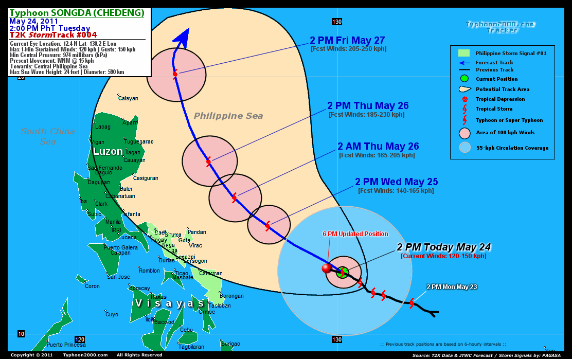
SONGDA (CHEDENG) - the first Typhoon of 2011, has maintained its WNW movement as it continues to threaten the East Coast of the Bicol Region particularly Catanduanes.
Residents and visitors along the Eastern Coast of Luzon, Bicol Region & Eastern Visayas should closely monitor the progress of SONGDA (CHEDENG).
Do not use this for life or death decision. This advisory is intended for additional information purposes only. Kindly refer to your country's official weather agency for local warnings, advisories & bulletins.
CURRENT STORM INFORMATION
Time/Date: 6:00 PM PhT Tue May 24 2011
Location of Eye: 12.6º N Lat 129.5º E Lon
Distance 1: 460 km (250 nm) ENE of Borongan City
Distance 2: 530 km (285 nm) East of Catarman, N.Samar
Distance 3: 585 km (315 nm) ESE of Virac, Catanduanes
Distance 4: 600 km (325 nm) ESE of Sorsogon City
Distance 5: 630 km (340 nm) ESE of Legazpi City
Distance 6: 690 km (372 nm) ESE of Metro Naga/CWC
MaxWinds (1-min avg): 120 kph (65 kts) near the center
Peak Wind Gusts: 150 kph (80 kts)
Present Movement: WNW @ 15 kph (08 kts)
Towards: Northern Philippine Sea
CPA near Bicol Coast: 8PM Wed-8AM Thu
24hr Rainfall Accum (near center): 350 mm (High)
Rainrate (near center): 20-30 mm/hr (Mod-Heavy)
Minimum Central Pressure: 974 millibars (hPa)
Saffir-Simpson Typhoon Scale: Category 1
Size (in Diameter): 590 km (320 nm) / Average
Max Sea Wave Height (near center): 24 ft (7.3 m)
Possible Storm Surge Height: 4-5 ft [1.2-1.7 m]
T2K TrackMap (for Public): 6:00 PM PhT Tue May 24
FORECAST OUTLOOK ANALYSIS (up to 48 hours)* EXTENDED FORECAST TRACK (3 to 5 days)*
SONGDA (CHEDENG) is expected to continue intensifying while maintaining its WNW to NW track across the Philippine Sea within the next 2 days. The typhoon is likely to pass to the NE of Bicol Region (still at sea) between Wednesday afternoon until Thursday afternoon, where stormy weather will be expected [2AM MAY 25: 13.1N 128.1E @ 120kph...2PM MAY 25: 14.2N 127.3E @ 140kph]. As SONGDA passes to the NE of Bicol Region - it will therefore gain more strength - becoming a Category 3 Typhoon on Thursday afternoon (May 26)...about 315 km ENE of Casiguran, Aurora [2AM MAY 26: 15.3N 126.0E @ 165kph...2PM MAY 26: 16.7N 125.0E @ 185kph]. Its closest approach (CPA) to Catanduanes shall be about 270 km NE of Virac between 12 to 2AM on Thursday; and about 240 km NE of Pandan between 2-4AM Thursday (May 26). While its closest approach (CPA) to Camarines Sur shall be about 290 km NE of Caramoan or 360 km NE of Metro Naga between 2-4AM Thursday. Over Albay, its CPA shall be about 350 km NE of Legazpi City between 12-2AM Thursday.
Maximum Sustained Winds (1-min. avg) are near 120 km/hr (65 knots) with higher gusts. SONGDA (CHEDENG) is a Category 1 Typhoon on the Saffir-Simpson Tropical Cyclone Scale. Typhoon Force Winds (118 km/hr or more) extend outward up to 45 kilometers (25 nautical miles) from the center...and Tropical Storm Force Winds (62-117 km/hr) extend outward up to 195 kilometers (105 nautical miles). SONGDA is an average-sized tropical cyclone with a diameter of 590 kilometers (320 nautical miles).  FRIDAY AFTERNOON: Starts to recurve towards the north, while passing just to the east of the Batanes Group of Islands...about 195 km ESE of Basco, Batanes [2PM MAY 27: 20.1N 123.7E @ 205kph]. SATURDAY AFTERNOON: Starts to decay...accelerating NE-ward while passing very close to the Yaeyama Island Chain...about 110 km ESE of Ishigaki Island [2PM MAY 28: 24.1N 125.2E @ 185kph]. SUNDAY AFTERNOON: Starts to become an Extratropical Cyclone upon moving out of the Philippine Area of Responsibility (PAR) - passing swiftly over Okinawa-Ryukyu Islands...about 250 km SSE of Kagoshima, Japan [2PM MAY 29: 29.5N 131.4E @ 195kph].
*Please be reminded that the Forecast Outlook changes every 6 hours, and the Extended Forecast Track have an average error of 250 km on Day 3...450 km on Day 4...and 650 km on Day 5, while the wind speed forecast error, averages 35 kph per day. Therefore, a turn to the left or right of its future track and changes in its wind speed must be anticipated from time to time.
EFFECTS & HAZARDS SUMMARY
SONGDA's circulation has developed an EYE with an organizing intense wall of cloud along its periphery (Eyewall). Below are the summary of the storm's parts and its hazards affecting specific areas: EYE - over water (Philippine Sea)...not affecting any land areas. Possible calm and lull conditions (with <20 kph winds) can be expected inside the eye (click here to know more about the EYE). EYEWALL - over water (Philippine Sea)...not affecting any land areas. Typhoon Conditions with typhoon force winds (>118 kph) can be expected within this wall (click here to know more about the Eyewall). INNER RAINBANDS - over water...not affecting any land areas. Tropical Storm Conditions w/ Tropical Storm Force Winds (65-117 kph) can be expected along these bands. OUTER RAINBANDS - spreading across Samar Island & Bicol Region Tropical Depression Conditions w/ moderate to strong winds (30-61 kph) can be expected along these bands (click here to know more about Rainbands). 24HR TOTAL RAINFALL ACCUMULATION - from 5 up to 200 mm (low to high rainfall) can be expected along the outer & inner rainbands...with isolated amounts of up to 350 mm (high) near the center of SONGDA. [click to open NOAA's eTRaP graphic]. COASTAL STORM SURGE FLOODING - possible 4 to 5 feet above normal tide levels...accompanied by large and dangerous battering waves can be expected along the coastal and beach front areas of Bicol Region beginning tomorrow afternoon. Minimal damage is likely on this type of storm surge. Danger from Rip Currents or Rip Tides can be expected along the beach-front areas of Eastern Visayas and Eastern Luzon beginning tomorrow. (click here to know more about Storm Surge).
CURRENT I.T.C.Z. (MONSOON TROUGH) INTENSITY: STRONG >> Partly sunny to mostly cloudy with scattered to widespread showers, rains & thunderstorms will prevail along the following affected areas: SOUTHERN LUZON, BICOL REGION, VISAYAS & MINDANAO. Light to moderate SE to variable winds (not in excess of 35 kph) will be expected.
Important Note: Please keep in mind that the above forecast outlook, extended forecast, effects-hazards, current monsoon intensity, & tropical cyclone watch changes every 6 to 12 hrs!![]()
PAGASA Philippine Storm Warnings Signals
PHILIPPINE STORM WARNING SIGNAL # ONE (1) 
In Effect: CAMARINES SUR, CAMARINES NORTE, CATANDUANES, ALBAY, SORSOGON, & SAMAR PROVINCES.
The above areas will have rains and winds of not more than 60 kph beginning tomorrow. Coastal waters will be moderate to rough.
Residents living in low-lying and mountainous areas under Public Storm Warning Signal Number 1 are alerted against flashfloods, mudslides and landslides...while those living in coastal & beach-front areas are advised to seek higher grounds due to possible storm surge (aka. big waves).
JTWC (US NAVY & AIR FORCE) REMARKS:
REMARKS (for Meteorologists): 2 PM (06 GMT) TUE 24 MAY POSITION: 12.4N 130.2E.
*TROPICAL STORM (TS) 04W (SONGDA), LOCATED APPROXIMATELY 560 NM EAST-
SOUTHEAST OF MANILA, PHILIPPINES, HAS TRACKED WEST-NORTHWESTWARD AT
08 KNOTS OVER THE PAST SIX HOURS. THE SYSTEM HAS SUSTAINED A STEADY
TRACK AND SLOW RATE OF INTENSIFICATION DURING THE PAST 12 HOURS.
ANIMATED WATER VAPOR IMAGERY CONFIRMS THAT THE UPPER LEVEL TROUGH
THAT HAD BEEN DAMPENING OUTFLOW OVER THE NORTHWESTERN FLANK OF THE
STORM IS FILLING, AND THE SYSTEM IS BEGINNING TO INTENSIFY. ANIMATED
VISUAL IMAGERY CONFIRMS IMPROVING ORGANIZATION AND THICKENING
CONVECTIVE BANDING AROUND THE LOW LEVEL CIRCULATION CENTER (LLCC). A
240435Z AMSRE PASS ALSO VERIFIES THE DEVELOPMENT OF DEEP CONVECTION
ALONG BOTH THE NORTHERN AND SOUTHERN BOUNDARIES OF THE LLCC. THE
BANDS OF DEEP CONVECTION ARE STILL LIMITED, HOWEVER, AND THE 37GHZ
IMAGE FROM THE SAME PASS SHOWS A LACK OF LOW LEVEL BANDING OVER THE
SOUTHEASTERN QUADRANT. THE CURRENT INTENSITY ANALYSIS IS BASED ON A
DVORAK ESTIMATE OF 55 KNOTS FROM PGTW COMBINED WITH AN OBSERVED
IMPROVEMENT IN ORGANIZATION. TS SONGDA IS CURRENTLY TRACKING TOWARDS
A BROAD WEAKNESS IN THE SUB-TROPICAL RIDGE THAT EXISTS OVER THE
PHILIPPINE SEA. ALONG-TRACK CONDITIONS WILL BECOME INCREASINGLY
FAVORABLE AS THE SYSTEM APPROACHES NORTHEASTERN LUZON, WHERE IT
WILL ENCOUNTER SEA SURFACE TEMPERATURES NEAR 30 DEGREES CELSIUS AND
LESS THAN 10 KNOTS OF VERTICAL WIND SHEAR. DYNAMIC AIDS ARE IN GOOD
AGREEMENT WITH A SLOW BEND AROUND THE WESTERN PERIPHERY OF THE SUB-
TROPICAL RIDGE AND AN EXTRA-TROPICAL TRANSITION AND ACCELERATION
INTO THE MID-LATITUDES. DYNAMIC AIDS ARE IN GOOD OVERALL AGREEMENT
WITH THAT SCENARIO WITH THE EXCEPTION OF EGRR AND JGSM, WHICH TRACK
THE SYSTEM INTO EXTREME NORTHEASTERN LUZON AND OUT INTO THE LUZON
STRAIT. NORTH OF 25 DEGREES NORTH LATITUDE, FALLING SEA SURFACE
TEMPERATURES AND SHARPLY DIMINISHED OCEAN HEAT CONTENT COMBINED WITH
INCREASING VERTICAL WIND SHEAR ASSOCIATED WITH THE MID-LATITUDE
WESTERLIES WILL COMBINE TO WEAKEN THE STORM AS IT TRACKS OVER THE
RYUKUS...(more)
>> SONGDA, meaning: A river in northwestern Viet Nam. Name contributed by:Viet Nam.
_______________________________________________________________________________________________________________________________________
RECENT TYPHOON2000.COM TRACKING CHART:
_________________________________________________________________________________________________________________
RECENT MULTI-AGENCY TROPICAL CYCLONE FORECAST TRACKING CHART: 

> Image source: NOAA SATELLITE CENTER: http://www.ssd.noaa.gov/mtsat/flt/t1/rgb.jpg
> Image source: Wunderground.com Tropical Page (http://www.wunderground.com/tropical)
____________________________________________________________________________________________________________________
LATEST 24 HR. TOTAL RAINFALL AMOUNTS / ENSEMBLE TROPICAL RAINFALL POTENTIAL (eTRaP):

> Image source: NOAA Satellite & Information Service (http://www.ssd.noaa.gov/PS/TROP/etrap.html)
>> To know the meteorological terminologies and acronyms used on this update visit the ff:
http://typhoon2000.ph/tcterm.htm
http://www.nhc.noaa.gov/aboutgloss.shtml
http://www.srh.noaa.gov/oun/severewx/glossary.php
http://www.srh.weather.gov/fwd/glossarynation.html
http://www.nhc.noaa.gov/acronyms.shtml
__________________________________________________________________________________________
For the complete details on TY SONGDA (CHEDENG)...go visit our website @:
> http://www.typhoon2000.com
> http://www.maybagyo.com
Copyright © 2011 Typhoon2000.com All Rights Reserved

No comments:
Post a Comment