
for Monday, 09 May 2011 [7:28 AM PhT]![]()

<<<Typhoon2000.com Mobile >>>
Get the latest 6-Hourly SMS Storm Alerts on BEBENG!
For more details: Text T2K TYPHOON to
2800 (Globe/TM) | 216 (Smart/TNT) | 2288 (Sun)
*only P2.50 (Smart/Globe) / P2.00 (Sun) per msg received.
powered by: Synermaxx
Typhoon2000 (T2K) NEWS (Tuesday May 10 2011):
Currently issuing 6-hrly web and e-mail updates (except 12 AM) on TS AERE (BEBENG).
AERE (BEBENG) MAX WIND SPEED PER AGENCY:
+ USA (JTWC/1-min avg): 75 km/hr
+ Japan (JMA/10-min avg): 65 km/hr
+ Philippines (PAGASA/10-min avg): 65 km/hr
+ Beijing (NMC/2-min avg): 65 km/hr
+ Korea (KMA/10-min avg): 70 km/hr
+ Taiwan (CWB/10-min avg): 65 km/hr
+ Hong Kong (HKO/10-min avg): 65 km/hr
:: Click here to see Multi-Agency Forecast Tracks
TROPICAL STORM AERE [BEBENG/03W/1101]
T2K PUBLIC ADVISORY NUMBER 013
6:00 AM PhT (22:00 GMT) Tue 10 May 2011
Sources: T2K Extrap Analysis/JTWC Warning #015/SatFixes
View: Advisory Archives (2004-2011)
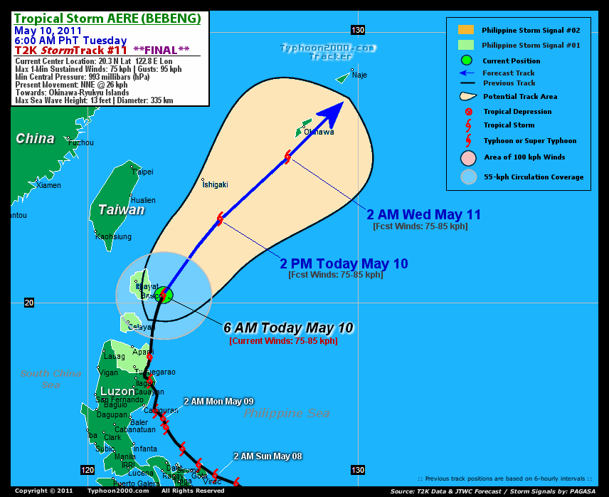
Tropical Storm AERE (BEBENG) has started to accelerate NNE away from Luzon...now passing to the east of Batanes Islands.
Residents and visitors along Ishigaki, Okinawa & Ryukyu Islands should closely monitor the progress of AERE (BEBENG).
Do not use this for life or death decision. This advisory is intended for additional information purposes only. Kindly refer to your country's official weather agency for local warnings, advisories & bulletins.
CURRENT STORM INFORMATION FORECAST OUTLOOK ANALYSIS (up to 48 hours)* EXTENDED FORECAST TRACK (3 days)* EFFECTS & HAZARDS SUMMARY CURRENT ENHANCED SW WINDFLOW INTENSITY: STRONG >> Cloudy with scattered to widespread showers, rains & thunderstorms will be expected along these following affected areas: LUZON INCL. METRO MANILA, BICOL REGION, ROMBLON, MARINDUQUE, ROMBLON, AND THE CALAMIAN GROUP OF ISLANDS. Light to moderate SW'ly winds (not in excess of 35 kph) will also be expected within this windflow.
Time/Date: 6:00 AM PhT Tue May 10 2011
Location of Center: 20.3º N Lat 122.8º E Lon
Distance 1: 85 km (45 nm) East of Basco, Batanes
Distance 2: 175 km (95 nm) NE of Calayan Is.
Distance 3: 245 km (132 nm) NNE of Aparri, Cagayan
Distance 4: 320 km (173 nm) NNE of Tuguegarao City
Distance 5: 500 km (270 nm) SSW of Ishigaki Is.
MaxWinds (1-min avg): 75 kph (40 kts) near the center
Peak Wind Gusts: 95 kph (55 kts)
Present Movement: NNE @ 26 kph (14 kts)
Towards: Okinawa-Ryukyus Area
CPA over Okinawa: 1PM-9PM Tue
24hr Total Rainfall (near center): 175 mm (Heavy)
Minimum Central Pressure: 993 millibars (hPa)
Saffir-Simpson Typhoon Scale: TS
Size (in Diameter): 335 km (180 nm) / Small/Avg
Max Sea Wave Height (near center): 13 ft (3.9 m)
Possible Storm Surge Height: 0-3 ft [0-0.9 m]
T2K Final TrackMap (for Public): 6:00 AM PhT Tue May 10
AERE (BEBENG) is expected to maintain its strength and accelerate NNE to NE-ward for the next 2 days - leaving the Philippine Area of Responsibility (PAR) by tomorrow May 11. It shall pass very close to the south of Okinawa Island before 4-5PM Japan Time tomorrow [2PM MAY 10: 21.0N 123.2E @ 75kph...2AM MAY 11: 23.1N 124.9E @ 75kph]...2PM MAY 12: 25.4N 127.4E @ 75kph...2AM MAY 12: 28.0N 130.7E @ 65kph.
Maximum Sustained Winds (1-min. avg) are near 75 km/hr (40 knots) with higher gusts. AERE (BEBENG) is a Tropical Storm on the Saffir-Simpson Tropical Cyclone Scale. Tropical Storm Force Winds (62-95 km/hr) extend outward up to 75 kilometers (40 nautical miles) from the center. AERE is a small tropical cyclone with a diameter of 335 kilometers (180 nautical miles).  FRIDAY EARLY MORNING: Downgraded into a Tropical Depression (TD)...attains Extratropical status while zooms past to the south of Honshu, Japan...about 210 km SSE of Tokyo, Japan. [2AM MAY 13: 33.9N 140.4E @ 55kph].
*Please be reminded that the Forecast Outlook changes every 6 hours, and the Extended Forecast Track have an average error of 250 km on Day 3...450 km on Day 4...and 650 km on Day 5, while the wind speed forecast error, averages 35 kph per day. Therefore, a turn to the left or right of its future track and changes in its wind speed must be anticipated from time to time.
AERE's circulation has become somewhat disorganized as it accelerates NNE toward Okinawa Area. Below are the summary of the storm's parts and its hazards affecting specific areas: CENTRAL DENSE OVERCAST (CDO) - None. INNER RAINBANDS - over water. Tropical Depression Conditions w/ moderate to strong winds (30-61 kph) will be expected along these bands. OUTER RAINBANDS - spreading across portions of Northern Luzon - where light to moderate winds (<30 kph) will be expected along these bands. (click here to know more about Rainbands). 24HR TOTAL RAINFALL ACCUMULATION - from 5 up to 100 mm (light to moderate rain) can be expected along the outer & inner rainbands...with isolated amounts of up to 175 mm (heavy) near the center of AERE. [click to open NOAA's eTRaP graphic].
Important Note: Please keep in mind that the above forecast outlook, extended forecast, effects-hazards, current monsoon intensity, & tropical cyclone watch changes every 6 to 12 hrs!![]()
PAGASA Philippine Storm Warnings Signals
PHILIPPINE STORM WARNING SIGNAL # ONE (1) 
In Effect: CAGAYAN, APAYAO, BATANES-BABUYAN-CALAYAN GROUP OF ISLANDS.
The above areas will have rains and winds of not more than 60 kph today. Coastal waters will be moderate to rough.
Residents living in low-lying and mountainous areas under Public Storm Warning Signal Number 1 & 2 are alerted against possible flashfloods, mudslides and landslides...while those living in coastal & beach-front areas are advised to seek higher grounds due to possible storm surge (aka. big waves).
JTWC (US NAVY & AIR FORCE) REMARKS:
REMARKS (for Meteorologists): 2 AM (18 GMT) TUE 10 MAY POSITION: 19.0N 122.3E.
*TROPICAL STORM (TS) 03W (AERE), LOCATED APPROXIMATELY 275 NM NORTH-
NORTHEAST OF MANILA, PHILIPPINES, HAS TRACKED NORTHWARD AT 11 KNOTS
OVER THE PAST SIX HOURS. RECENT ANIMATED INFRARED SATELLITE IMAGERY
SHOWS A PARTIALLY EXPOSED LOW LEVEL CIRCULATION CENTER (LLCC) WITH
CONVECTION DISPLACED TO THE NORTHEAST AND SOUTHEAST. A 09/1731Z
AMSRE 89H MICROWAVE IMAGE ALSO INDICATES CURVED CONVECTIVE BANDING
ALONG THE NORTHEASTERN AND SOUTHEASTERN PERIPHERY OF THE LLCC. DUE
TO THE SLIGHTLY DISPLACED CONVECTION, CURRENT INTENSITY (40 KNOTS)
IS SLIGHTLY HIGHER THAN PGTW AND KNES DVORAK INTENSITY ESTIMATES OF
30-35 KNOTS. 09/1200Z UPPER AIR ANALYSIS INDICATES TS 03W IS JUST TO
THE EAST OF AN UPPER-LEVEL SUBTROPICAL TROUGH IN A REGION OF
MODERATE VERTICAL WIND SHEAR (VWS). THIS TROUGH IS INHIBITING
CONVECTION ALONG THE WESTERN PERIPHERY OF THE LLCC WHILE ENHANCING
DIFFLUENCE TO THE NORTHEAST OF THE SYSTEM. THIS STORM IS TRACKING
NORTHWARD ALONG THE WESTERN EDGE OF A POLEWARD-ORIENTED SUBTROPICAL
STEERING RIDGE AND IS EXPECTED TO TRACK MORE NORTHEASTWARD DURING
THE NEXT 12 HOURS AS IT ROUNDS THE RIDGE AXIS. DESPITE FAVORABLE
UPPER-LEVEL OUTFLOW IN MOST QUADRANTS, INCREASING VWS AND DECREASING
SSTS WILL PREVENT INTENSIFICATION. TS AERE WILL BEGIN EXTRATROPICAL
TRANSITION (ET) NEAR TAU 48 AND WILL CONTINUE TO WEAKEN THROUGH TAU
72 AS IT COMPLETES ET. NUMERICAL MODEL GUIDANCE IS IN GOOD
AGREEMENT; THEREFORE THIS FORECAST IS IN GOOD AGREEMENT WITH THE
MODEL CONSENSUS AND IS CONSISTENT WITH PREVIOUS FORECAST...(more)
>> AERE, meaning: A storm. Name contributed by: United States of America.
_______________________________________________________________________________________________________________________________________
RECENT TYPHOON2000.COM TRACKING CHART:
RECENT MULTI-AGENCY TROPICAL CYCLONE FORECAST TRACKING CHART:


> Image source: NOAA SATELLITE CENTER: http://www.ssd.noaa.gov/mtsat/flt/t1/rgb.jpg
> Image source: Wunderground.com Tropical Page (http://www.wunderground.com/tropical)
____________________________________________________________________________________________________________________
LATEST 24HR. TOTAL RAINFALL AMOUNTS / ENSEMBLE TROPICAL RAINFALL POTENTIAL (eTRaP):

> Image source: NOAA Satellite & Information Service (http://www.ssd.noaa.gov/PS/TROP/etrap.html)
>> To know the meteorological terminologies and acronyms used on this update visit the ff:
http://typhoon2000.ph/tcterm.htm
http://www.nhc.noaa.gov/aboutgloss.shtml
http://www.srh.noaa.gov/oun/severewx/glossary.php
http://www.srh.weather.gov/fwd/glossarynation.html
http://www.nhc.noaa.gov/acronyms.shtml
__________________________________________________________________________________________
For the complete details on TS AERE (BEBENG)...go visit our website @:
> http://www.typhoon2000.com
> http://www.maybagyo.com
Copyright © 2011 Typhoon2000.com All Rights Reserved

No comments:
Post a Comment