
for Sunday, 08 May 2011 [12:16 PM PhT]![]()

<<<Typhoon2000.com Mobile >>>
Get the latest 3-Hourly SMS Storm Alerts on BEBENG!
For more details: Text T2K TYPHOON to
2800 (Globe/TM) | 216 (Smart/TNT) | 2288 (Sun)
*only P2.50 (Smart/Globe) / P2.00 (Sun) per msg received.
powered by: Synermaxx
Typhoon2000 (T2K) NEWS (Saturday May 07 2011):
Currently issuing 3-hrly web and e-mail updates (except 12 AM) on TS AERE (BEBENG).
AERE (BEBENG) MAX WIND SPEED PER AGENCY:
+ USA (JTWC/1-min avg): 95 km/hr
+ Japan (JMA/10-min avg): 85 km/hr
+ Philippines (PAGASA/10-min avg): 85 km/hr
+ Beijing (NMC/2-min avg): 85 km/hr
+ Korea (KMA/10-min avg): 90 km/hr
+ Taiwan (CWB/10-min avg): 85 km/hr
+ Hong Kong (HKO/10-min avg): 85 km/hr
:: Click here to see Multi-Agency Forecast Tracks
TROPICAL STORM AERE [BEBENG/03W/1101]
T2K PUBLIC ADVISORY NUMBER 007
12:00 PM PhT (04:00 GMT) Sun 08 May 2011
Sources: T2K Extrap Analysis/JTWC Warning #008/SatFixes
View: Advisory Archives (2004-2011)
Tropical Storm AERE (BEBENG) has begun to accelerate Northward away from the Caramoan Peninsula & Catanduanes Island...Widespread heavy rains continuing across the Bicol Peninsula. The T2K Automated Weather Station in Naga City confirms rising barometric pressure reading of 1000.6 millibars (hPa) with a 12-hour rainfall observation of 205.0 mm.
Residents and visitors along Luzon and Bicol Region should closely monitor the progress of AERE (BEBENG).
Do not use this for life or death decision. This advisory is intended for additional information purposes only. Kindly refer to your country's official weather agency for local warnings, advisories & bulletins.
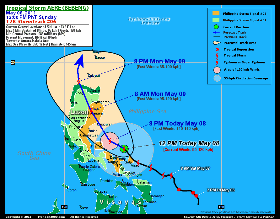
CURRENT STORM INFORMATION FORECAST OUTLOOK ANALYSIS (up to 48 hours)* EXTENDED FORECAST TRACK (3 to 5 days)* EFFECTS & HAZARDS SUMMARY CURRENT ITCZ/MONSOON TROUGH INTENSITY: MODERATE >> Partly sunny to mostly cloudy with scatt$ered showers, rains & thunderstorms can be expected along these following affected areas: PALAWAN & MINDANAO. Light to moderate NW, W, SW to variable winds (not in excess of 35 kph) can be expected today and tomorrow.
Time/Date: 12:00 AM PhT Sun May 08 2011
Location of Center: 14.5º N Lat 123.8º E Lon
Distance 1: 75 km (40 nm) NE of Siruma, CamSur
Distance 2: 80 km (43 nm) North of Caramoan, Cam Sur
Distance 3: 105 km (57 nm) ENE of Daet, CamNorte
Distance 4: 115 km (62 nm) NNW of Virac, Catanduanes
Distance 5: 120 km (65 nm) NE of Metro Naga/CWC
Distance 6: 130 km (70 nm) NNE of Iriga City
Distance 7: 155 km (83 nm) NNE of Legazpi City
Distance 8: 230 km (125 nm) ESE of Infanta, Quezon
Distance 9: 265 km (143 nm) SE of Casiguran, Aurora
Distance 10: 290 km (157 nm) East of Metro Manila
MaxWinds (1-min avg): 95 kph (50 kts) near the center
Peak Wind Gusts: 120 kph (55 kts)
Present Movement: NNW @ 19 kph (10 kts)
Towards: Aurora-Isabela Area
CPA over Aurora-Isabela: 2AM-8AM Monday
24hr Total Rainfall (near center): 400 mm (Very Heavy)
Minimum Central Pressure: 985 millibars (hPa)
Saffir-Simpson Typhoon Scale: TS
Size (in Diameter): 445 km (240 nm) / Average
Max Sea Wave Height (near center): 17 ft (5.1 m)
Possible Storm Surge Height: 0-3 ft [0-0.9 m]
T2K TrackMap (for Public): 12:00 PM PhT Sun May 08
AERE (BEBENG) is expected to maintain its NW to NNW-ward track for the next 2 days and intensify. This system shall make landfall along Aurora-Isabela Area early tomorrow morning (approx 3-5AM)...and cross Northern Luzon, passing over or very close to Cauayan, Isabela around 8AM tomorrow May 09; Kalinga & Apayao Provinces tomorrow afternoon...and shall move out into the Balintang Channel by tomorrow evening [8AM MAY 09: 16.9N 121.7E @ 95kph...8PM MAY 09: 18.8N 120.9E @ 85kph]. By Tuesday morning, AERE is forecast to turn North and shall be over the Bashi Channel or just to the west of Balintang Channel-Batanes Area - with decaying wind speeds [8AM MAY 10: 20.5N 121.0E @ 75kph].
Maximum Sustained Winds (1-min. avg) has increased to near 95 km/hr (50 knots) with higher gusts. AERE (BEBENG) is a strong Tropical Storm on the Saffir-Simpson Tropical Cyclone Scale. Tropical Storm Force Winds (62-117 km/hr) extend outward up to 205 kilometers (110 nautical miles) from the center. AERE is an average-sized tropical cyclone with a diameter of 445 kilometers (240 nautical miles).  WEDNESDAY MORNING: Just a minimal Tropical Storm as it accelerates toward the NE...about 175 km SE of Ishigaki Island [8AM MAY 11: 23.2N 123.3E @ 65kph]. THURSDAY MORNING: Downgraded to a Tropical Depression (TD) as it exits the Philippine Area of Responsibility (PAR)...passing near Okinawa Islands...becoming Extratropical...about 75 km NW of Okinawa Island, Japan [8AM MAY 12: 27.0N 127.5E @ 55kph]. FRIDAY MORNING: Completes Extratropical status...passing along the southern coast of Shikoku, Japan...about 170 km South of Kochi, Japan [8AM MAY 13: 32.1N 133.8E @ 55kph].
*Please be reminded that the Forecast Outlook changes every 6 hours, and the Extended Forecast Track have an average error of 250 km on Day 3...450 km on Day 4...and 650 km on Day 5, while the wind speed forecast error, averages 35 kph per day. Therefore, a turn to the left or right of its future track and changes in its wind speed must be anticipated from time to time.
AERE's circulation slightly in disarray as land interaction separated the Low-Level Circulation Center (LLCC) from the deep raincloud convection after traversing the northern part of Bicol Peninsula. Below are the summary of the storm's parts and its hazards affecting specific areas: CENTRAL DENSE OVERCAST (CDO) - over Partido District of Camarines Sur. Tropical Storm Conditions w/ Tropical Storm Force Winds (62-117 kph) will be expected along the CDO. (click here to know more about CDO). INNER RAINBANDS - affecting the Rest of Bicol Region including Masbate & Burias-Ticao Islands. Tropical Depression Conditions w/ moderate to strong winds (30-61 kph) will be expected along these bands. OUTER RAINBANDS - spreading across Southern Tagalog Provinces including NCR, Quezon, Aurora, Polillo Island, Mindoro, Romblon, Marinduque, Northern Palawan, & the Visayas - where light to moderate winds (<30 kph) will be expected along these bands. (click here to know more about Rainbands). 24HR TOTAL RAINFALL ACCUMULATION - from 5 up to 250 mm (light to heavy rain) can be expected along the outer & inner rainbands...with isolated amounts of up to 400 mm (very heavy) near the center of AERE. [click to open NOAA's eTRaP graphic].
Important Note: Please keep in mind that the above forecast outlook, extended forecast, effects-hazards, current monsoon intensity, & tropical cyclone watch changes every 6 to 12 hrs!![]()
PAGASA Philippine Storm Warnings Signals
PHILIPPINE STORM WARNING SIGNAL # TWO (2) 
In Effect: CATANDUANES, CAMARINES NORTE, CAMARINES SUR, NORTHERN QUEZON, POLILLO ISLAND, AURORA, NUEVA ECIJA, NUEVA VISCAYA, & ISABELA.
The above areas will experience stormy weather today (with winds not exceeding 100 kph). Coastal waters will be rough to very rough and extremely dangerous to all types of seacrafts. PHILIPPINE STORM WARNING SIGNAL # ONE (1) The above areas will have rains and winds of not more than 60 kph today. Coastal waters will be moderate to rough.
In Effect: SORSOGON, ALBAY, SOUTHERN QUEZON, LAGUNA, RIZAL, BULACAN, PAMPANGA, TARLAC, PANGASINAN, LA UNION, MT. PROVINCE, KALINGA, IFUGAO, SOUTHERN CAGAYAN, & NORTHERN SAMAR.
Residents living in low-lying and mountainous areas under Public Storm Warning Signal Number 1 & 2 are alerted against possible flashfloods, mudslides and landslides...while those living in coastal & beach-front areas are advised to seek higher grounds due to possible storm surge (aka. big waves).
JTWC (US NAVY & AIR FORCE) REMARKS:
REMARKS (for Meteorologists): 8 AM (00 GMT) SUN 08 MAY POSITION: 13.8N 124.0E.
*TROPICAL STORM (TS) 03W (AERE), LOCATED APPROXIMATELY 180 NM
EAST-SOUTHEAST OF MANILA, PHILIPPINES, HAS TRACKED WEST-
NORTHWESTWARD AT 07 KNOTS OVER THE PAST SIX HOURS. ANIMATED MULTI-
SPECTRAL SATELLITE IMAGERY (MSI) AND A 072213Z SSMIS 91H MICROWAVE
IMAGE DEPICT A SLIGHT WEAKENING IN CENTRAL CONVECTION ASSOCIATED
WITH WARMING CLOUD TOPS AND LAND INTERACTION. THE CURRENT INTENSITY
IS BASED ON DVORAK INTENSITY ESTIMATES RANGING FROM 45 TO 55 KNOTS
FROM PGTW AND KNES. THERE IS FAIR CONFIDENCE IN THE CURRENT POSITION
BASED ON THE AFOREMENTIONED MICROWAVE IMAGE AND PARTIAL EXPOSURE OF
THE LOW LEVEL CIRCULATION CENTER JUST WEST OF CATANDUANES,
PHILIPPINES IN MSI. A WATER VAPOR LOOP REVEALS GOOD RADIAL OUTFLOW
AND ENHANCED POLEWARD OUTFLOW AHEAD OF A TRANSITORY MID-LATITUDE
TROUGH, WHICH HAS ALLOWED THE SYSTEM TO INTENSIFY SLIGHTLY WITHIN
THE PAST 06 HOURS DESPITE INCREASED LAND INTERACTION. UPPER LEVEL
ANALYSIS CONTINUES TO INDICATE FAVORABLE VERTICAL WIND SHEAR (VWS)
AND STRONGLY DIFFLUENT FLOW ALOFT...(more)
>> AERE, meaning: A storm. Name contributed by: United States of America.
_______________________________________________________________________________________________________________________________________
RECENT TYPHOON2000.COM TRACKING CHART:
RECENT MULTI-AGENCY TROPICAL CYCLONE FORECAST TRACKING CHART:


> Image source: NOAA SATELLITE CENTER: http://www.ssd.noaa.gov/mtsat/flt/t1/rgb.jpg
> Image source: Wunderground.com Tropical Page (http://www.wunderground.com/tropical)
____________________________________________________________________________________________________________________
LATEST 24 HR. TOTAL RAINFALL AMOUNTS / ENSEMBLE TROPICAL RAINFALL POTENTIAL (eTRaP):

> Image source: NOAA Satellite & Information Service (http://www.ssd.noaa.gov/PS/TROP/etrap.html)
>> To know the meteorological terminologies and acronyms used on this update visit the ff:
http://typhoon2000.ph/tcterm.htm
http://www.nhc.noaa.gov/aboutgloss.shtml
http://www.srh.noaa.gov/oun/severewx/glossary.php
http://www.srh.weather.gov/fwd/glossarynation.html
http://www.nhc.noaa.gov/acronyms.shtml
__________________________________________________________________________________________
For the complete details on TS AERE (BEBENG)...go visit our website @:
> http://www.typhoon2000.com
> http://www.maybagyo.com
Copyright © 2011 Typhoon2000.com All Rights Reserved

No comments:
Post a Comment