
for Sunday, 08 May 2011 [3:21 AM PhT]![]()

<<<Typhoon2000.com Mobile >>>
Get the latest 3-Hourly SMS Storm Alerts on BEBENG!
For more details: Text T2K TYPHOON to
2800 (Globe/TM) | 216 (Smart/TNT) | 2288 (Sun)
*only P2.50 (Smart/Globe) / P2.00 (Sun) per msg received.
powered by: Synermaxx
Typhoon2000 (T2K) NEWS (Saturday May 07 2011):
Now issuing 3-hrly web and e-mail updates (except 12 AM) on TS AERE (BEBENG) as it approaches the Bicol Region.
AERE (BEBENG) MAX WIND SPEED PER AGENCY:
+ USA (JTWC/1-min avg): 85 km/hr
+ Japan (JMA/10-min avg): 75 km/hr
+ Philippines (PAGASA/10-min avg): 75 km/hr
+ Beijing (NMC/2-min avg): 85 km/hr
+ Korea (KMA/10-min avg): 75 km/hr
+ Taiwan (CWB/10-min avg): 75 km/hr
+ Hong Kong (HKO/10-min avg): 65 km/hr
:: Click here to see Multi-Agency Forecast Tracks
TROPICAL STORM AERE [BEBENG/03W/1101]
T2K PUBLIC INTERMEDIATE ADVISORY NUMBER 005A
3:00 AM PhT (19:00 GMT) Sun 08 May 2011
Sources: T2K Extrap Analysis/JTWC Warning #006/SatFixes
View: Advisory Archives (2004-2011)
Tropical Storm AERE (BEBENG) remains over Albay Gulf as it drifted Westward for the past 3 hours...Stormy weather being felt across Bicol Region and Samar Provinces.
Residents and visitors along Eastern Luzon, Bicol Region & Eastern Visayas should closely monitor the progress of AERE (BEBENG).
Do not use this for life or death decision. This advisory is intended for additional information purposes only. Kindly refer to your country's official weather agency for local warnings, advisories & bulletins.
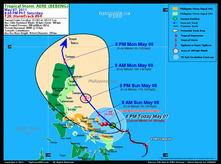
CURRENT STORM INFORMATION
Time/Date: 3:00 AM PhT Sun May 08 2011
Location of Center: 13.3º N Lat 124.6º E Lon
Distance 1: 55 km (30 nm) ESE of Virac, Catanduanes
Distance 2: 90 km (47 nm) North of Catarman, N.Samar
Distance 3: 75 km (40 nm) ENE of Sorsogon City
Distance 4: 100 km (55 nm) ENE of Legazpi City
Distance 5: 105 km (57 nm) ESE of Gota Beach
Distance 6: 130 km (70 nm) East of Iriga City
Distance 7: 155 km (83 nm) ESE of Metro Naga/CWC
Distance 8: 160 km (85 nm) ESE of Siruma, CamSur
Distance 9: 205 km (110 nm) ESE of Daet/Ragay
Distance 10: 405 km (220 nm) ESE of Metro Manila
MaxWinds (1-min avg): 85 kph (45 kts) near the center
Peak Wind Gusts: 100 kph (55 kts)
Present Movement: WNW @ 13 kph (07 kts)
Towards: Catanduanes
CPA over Bicol Area: 2AM-2PM Sunday
24hr Total Rainfall (near center): 460 mm (Very Heavy)
Minimum Central Pressure: 989 millibars (hPa)
Saffir-Simpson Typhoon Scale: TS
Size (in Diameter): 445 km (240 nm) / Average
Max Sea Wave Height (near center): 16 ft (4.8 m)
Possible Storm Surge Height: 0-3 ft [0-0.9 m]
T2K TrackMap (for Public): 3:00 PM PhT Sun May 08
FORECAST OUTLOOK ANALYSIS (up to 48 hours)* EXTENDED FORECAST TRACK (3 to 5 days)*
AERE (BEBENG) is expected to maintain its NW to NNW-ward movement for the next 2 days and will continue to intensify while moving closer towards the eastern coast of Bicol Peninsula. This system will pass very close to the Northern tip of Catanduanes tomorrow morning (Sun May 08) between 7-8AM...or about 75 km to the North of Virac, Catanduanes or about 140 km NE of Metro Naga - its Closest Point of Approach (CPA), and shall be reaching its peak strength of 110 kph tomorrow evening...about 135 km ESE of Casiguran, Aurora [8AM MAY 08: 14.3N 124.3E @ 95kph...8PM MAY 08: 15.6N 123.2E @ 110kph]. AERE shall make landfall just south of Palanan Bay in Isabela between 5-6AM on Monday May 09, and cross Northern Luzon, passing very close to Tuguegarao City, Cagayan around 1-2PM (Monday May 09). On Monday evening, AERE shall exit Northern Luzon via the NW coast of Cagayan...about 50 km NW of Aparri, Cagayan [8AM MAY 09: 17.2N 122.2E @ 100kph...8PM MAY 09: 18.8N 121.4E @ 95kph].
Maximum Sustained Winds (1-min. avg) are now near 85 km/hr (45 knots) with higher gusts. AERE (BEBENG) is a Tropical Storm on the Saffir-Simpson Tropical Cyclone Scale. Continued strengthening can be expected tonight & tomorrow.  TUESDAY EVENING: Weakening gradually while over the Bashi Channel...about 95 km NW of Basco, Batanes [8PM MAY 10: 21.2N 121.5E @ 65kph]. WEDNESDAY EVENING: Downgraded to a Tropical Depression (TD) while passing over the Yaeyama Islands...about 30 km SW of Ishigaki Island [8PM MAY 11: 24.3N 124.0E @ 55kph]. THURSDAY EVENING: Accelerating NE-ward as it exits the Philippine Area of Responsibility (PAR)...becoming an Extratropical Cyclone...about 180 km North of Okinawa Island, Japan [8PM MAY 12: 28.1N 127.7E @ 55kph].
*Please be reminded that the Forecast Outlook changes every 6 hours, and the Extended Forecast Track have an average error of 250 km on Day 3...450 km on Day 4...and 650 km on Day 5, while the wind speed forecast error, averages 35 kph per day. Therefore, a turn to the left or right of its future track and changes in its wind speed must be anticipated from time to time.
EFFECTS & HAZARDS SUMMARY
AERE's circulation rapidly intesifying while over the warm waters of Albau Gulf - with its broad rainbands affecting the Bicol Region, Southern Quezon, Visayas, Northeastern Mindanao & nearby areas. Below are the summary of the storm's parts and its hazards affecting specific areas: CENTRAL DENSE OVERCAST (CDO) - over Albay Gulf. Severe Tropical Storm Conditions w/ near-Typhoon Force Winds (85-100 kph) can be expected (click here to know more about CDO). INNER RAINBANDS - affecting Samar Provinces, Camarines Sur, Catanduanes, Albay, Sorsogon, & Burias-Ticao Islands...expected to reach the rest of Bicol Region tomorrow morning. Tropical Storm Conditions w/ Tropical Storm Force Winds (65-85 kph) can be expected along these bands. OUTER RAINBANDS - spreading across the Rest of Bicol Region, Masbate, Rest of Visayas, Eastern Mindoro, Marinduque, & Southern Quezon - where light to moderate winds (<60 kph) can be expected along these bands. (click here to know more about Rainbands). 24HR TOTAL RAINFALL ACCUMULATION - from 5 up to 300 mm (light to heavy rain) can be expected along the outer & inner rainbands...with isolated amounts of up to 460 mm (very heavy) near the center of 03W. [click to open NOAA's eTRaP graphic].
CURRENT ITCZ/MONSOON TROUGH INTENSITY: MODERATE >> Partly sunny to mostly cloudy with scatt$ered showers, rains & thunderstorms can be expected along these following affected areas: PALAWAN, MINDANAO & SOUTHERN LUZON. Light to moderate NW, W, SW to variable winds (not in excess of 35 kph) can be expected today and tomorrow.
Important Note: Please keep in mind that the above forecast outlook, extended forecast, effects-hazards, current monsoon intensity, & tropical cyclone watch changes every 6 to 12 hrs!![]()
PAGASA Philippine Storm Warnings Signals
PHILIPPINE STORM WARNING SIGNAL # TWO (2) 
In Effect: SORSOGON, TICAO ISLAND, ALBAY, BURIAS ISLAND, CAMARINES SUR, CAMARINES NORTE, SOUTHERN QUEZON, CATANDUANES, & NORTHERN SAMAR.
The above areas will experience stormy weather tonight & tomorrow (with winds not exceeding 100 kph). Coastal waters will be rough to very rough and extremely dangerous to all types of seacrafts. PHILIPPINE STORM WARNING SIGNAL # ONE (1) The above areas will have rains and winds of not more than 60 kph tonight until tomorrow. Coastal waters will be moderate to rough.
In Effect: BILIRAN, MASBATE, ROMBLON, MARINDUQUE, REST OF QUEZON, POLILLO ISLAND, NUEVA ECIJA, NUEVA VISCAYA, QUIRINO, AURORA, ISABELA, EASTERN & WESTERN SAMAR.
Residents living in low-lying and mountainous areas under Public Storm Warning Signal Number 1 & 2 are alerted against possible flashfloods, mudslides and landslides...while those living in coastal & beach-front areas are advised to seek higher grounds due to possible storm surge (aka. big waves).
_______________________________________________________________________________________________________________________________________
RECENT TYPHOON2000.COM TRACKING CHART:
RECENT MULTI-AGENCY TROPICAL CYCLONE FORECAST TRACKING CHART:


> Image source: NOAA SATELLITE CENTER: http://www.ssd.noaa.gov/mtsat/flt/t1/rgb.jpg
> Image source: Wunderground.com Tropical Page (http://www.wunderground.com/tropical)
____________________________________________________________________________________________________________________
LATEST 24 HR. TOTAL RAINFALL AMOUNTS / ENSEMBLE TROPICAL RAINFALL POTENTIAL (eTRaP):

> Image source: NOAA Satellite & Information Service (http://www.ssd.noaa.gov/PS/TROP/etrap.html)
>> To know the meteorological terminologies and acronyms used on this update visit the ff:
http://typhoon2000.ph/tcterm.htm
http://www.nhc.noaa.gov/aboutgloss.shtml
http://www.srh.noaa.gov/oun/severewx/glossary.php
http://www.srh.weather.gov/fwd/glossarynation.html
http://www.nhc.noaa.gov/acronyms.shtml
__________________________________________________________________________________________
For the complete details on TS AERE (BEBENG)...go visit our website @:
> http://www.typhoon2000.com
> http://www.maybagyo.com
Copyright © 2011 Typhoon2000.com All Rights Reserved

No comments:
Post a Comment