
for Wednesday, 20 October 2010 [10:01 AM PhT]![]()

<<<Typhoon2000.com Mobile >>>
Get the latest 6-hrly SMS Storm Alerts on JUAN!
For more details: Text T2K TYPHOON to
2800 (Globe/TM) | 216 (Smart/TNT) | 2288 (Sun)
*only P2.50 (Smart/Globe) / P2.00 (Sun) per msg received.
powered by: Synermaxx
Typhoon2000 (T2K) NEWS (Tuesday Oct 19 2010):
Ending the 3-hrly Web & SMS updates (except 12 AM) on MEGI (JUAN)...now back to its usual 6-hrly updates.
MEGI (JUAN) MAX WIND SPEED PER AGENCY:
+ USA (JTWC/1-min avg): 215 km/hr
+ Japan (JMA/10-min avg): 165 km/hr
+ Philippines (PAGASA/10-min avg): 175 km/hr
+ Korea (KMA/10-min avg): 160 km/hr
+ Taiwan (CWB/10-min avg): 170 km/hr
+ Beijing (NMC/2-min avg): 185 km/hr
+ Hong Kong (HKO/10-min avg): 175 km/hr
TYPHOON MEGI [JUAN/15W/1013]
T2K E-MAIL ADVISORY NUMBER 022
6:00 AM PhT (22:00 GMT) Wed 20 October 2010
Sources: T2K Extrap Analysis/JTWC Wrng #028/SatFixes
View: Advisory Archives (2004-2010)
Typhoon MEGI (JUAN) rapidly re-intensifies into Category 4...crawling WNW across the South China Sea...away from Luzon, Philippines...threatens Southern China particularly Central & Eastern Guangdong.
Residents and visitors along Southern China should closely monitor the progress of MEGI (JUAN).
Do not use this for life or death decision. This advisory is intended for additional information purposes only. Kindly refer to your country's official weather agency for local warnings, advisories & bulletins.
CURRENT STORM INFORMATION ANALYSIS & FORECAST OUTLOOK (up to 48 hours)* EXTENDED FORECAST TRACK (3 to 5 days)* EFFECTS & HAZARDS SUMMARY TROPICAL CYCLONE WATCH Important Note: Please keep in mind that the above forecast outlook, extended forecast, effects-hazards, current monsoon intensity, & tropical cyclone watch changes every 6 to 12 hrs! PHILIPPINE STORM WARNING SIGNAL # ONE (1) The above areas will have rains and winds of not more than 60 kph today. Coastal waters will be moderate to rough.
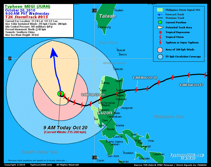
Time/Date: 6:00 AM PhT Tue Oct 20 2010
Location of Eye: 17.1º N Lat 117.2º E Lon
Distance 1: 290 km (155 nm) WNW of Bolinao, Pangasinan
Distance 2: 335 km (180 nm) WNW of San Fernando City
Distance 3: 345 km (187 nm) WSW of Vigan City
Distance 4: 350 km (190 nm) WNW of Dagupan City
Distance 5: 500 km (270 nm) NW of Metro Manila
Distance 6: 650 km (352 nm) SE of Hong Kong
MaxWinds (1-min avg): 215 kph (115 kts) near the center
Peak Wind Gusts: 260 kph (140 kts)
Present Movement: WNW @ 11 kph (06 kts)
Towards: Southern China (Eastern Guangdong)
24-hr Total Rainfall (near center): 500 mm (Very Heavy)
Minimum Central Pressure: 945 millibars (hPa)
Saffir-Simpson Typhoon Scale: Category 4
Size (in Diameter): 925 km (500 nm) / Very Large
Max Sea Wave Height (near center): 34 ft (10.3 m)
Possible Storm Surge Height: 13-18 ft [4-5.5 m]
T2K TrackMap #013 (for Public): 9 AM PhT Wed Oct 20
MEGI is currently showing an improved organization with a 28-km irregular eye at the center...and continues to have a very large circulation (>890 km) covering the whole extent of the South China Sea. The typhoon is expected to turn slowly NW to NNW-ward towards Southern China within the next two days. MEGI is forecast to intensify to near-Super Typhoon strength sometime tomorrow and will start to decay as it approaches the shores of Eastern Guangdong, just to the east of Hong Kong on Friday [2AM OCT 21: 18.4N 117.3E @ 230kph...2AM OCT 22: 20.7N 116.8E @ 195kph].
Maximum Sustained Winds (1-min. avg) have rapidly increased to near 215 km/hr (115 knots) with higher gusts. MEGI is now a Category 4 Typhoon on the Saffir-Simpson Tropical Cyclone Scale. Additional strengthening can still be expected tomorrow - as the system moves across the warm waters of the South China Sea. Typhoon Force Winds (118 km/hr or more) extend outward up to 110 kilometers (60 nautical miles) from the center...and Tropical Storm Force Winds (62-117 km/hr) extend outward up to 270 kilometers (145 nautical miles). MEGI remains a very large-sized tropical cyclone, measuring 925 kilometers (500 nautical miles) across.  SATURDAY EARLY MORNING: Making landfall over Eastern Guangdong, about 100 km SW of Shantou City or 200 km ENE of Hong Kong...downgraded to Cateogry 2 [2AM OCT 23: 22.9N 116.0E @ 175kph]. SUNDAY EARLY MORNING: Rapidly dissipating off the mountains of Guangdong Province...about 215 km NE of Hong Kong...weakens into a tropical storm [2AM OCT 24: 23.9N 115.2E @ 110kph]. MONDAY EARLY MORNING Just barely a tropical storm as it continues to dissipate along the Jiangxi-Gunagdong Border...about 280 km north of Hong Kong. [2AM OCT 25: 24.7N 114.2E @ 65kph].
*Please be reminded that the Forecast Outlook changes every 6 hours, and the Extended Forecast Track have an average error of 250 km on Day 3...450 km on Day 4...and 650 km on Day 5, while the wind speed forecast error, averages 35 kph per day. Therefore, a turn to the left or right of its future track and changes in its wind speed must be anticipated from time to time.
MEGI's very large convective circulation continues to cover the whole of Luzon including Palawan and Mindoro. IRREGULAR EYE [28-km diameter] - remains over water (South China Sea). EASTERN EYEWALL - over water (South China Sea). INNER RAINBANDS - its outer edges still affecting the western shoreline of Pangasinan, where Tropical Storm Conditions w/ Tropical Storm Force Winds (65-117 kph) will prevail today. OUTER RAINBANDS - spreading across the whole of Luzon (except Cagayan, Isabela & Northern Aurora), Mindoro, Lubang Is, Calamian Group, & Northern Palawan. Moderate to strong winds with passing on-and-off rains or showers will continue to prevail along these areas today. 24-HR TOTAL RAINFALL ACCUMULATION - from 5 up to 200 mm (light to heavy rain) can be expected along the outer and inner rainbands...with isolated amounts of up to 500 mm (very heavy) near the center of MEGI [view current NOAA's eTRaP graphic]. COASTAL STORM SURGE FLOODING - possible 13 to 18 feet above normal tide levels...accompanied by large and dangerous battering waves are possible along the coastal and beach front areas of Southern China beginning Friday. Extreme damage is likely on this type of storm surge. Danger from large swells and Rip Currents or Rip Tides can be expected along the rest of the beach-front areas of Vietnam and Western Luzon in the Philippines today.
A new and strong Tropical Disturbance 95W (LPA/1006 MB) has been spotted to the ENE of Guam in the Marianas. It was located near lat 10.5N lon 140.8E...or about 250 km east of Saipan, CNMI...with 1-min maximum sustained winds of 35 kph near the center...moving West @ 19 kph towards Northern Marianas. The 24 to 48-Hr. Tropical Cyclone Formation Potential on this system is at 60%. Click here to view current satellite image and flash animation. ![]()
PAGASA Philippine Storm Warnings Signals

In Effect: ILOCOS NORTE, ILOCOS SUR, LA UNION, BENGUET, PANGASINAN, & ZAMBALES.
Residents living in low-lying and mountainous areas under Public Storm Warning Signal Numbers 2, & 1 are alerted against flashfloods, mudslides and landslides...while those living in coastal & beach-front areas are advised to seek higher grounds due to possible storm surge (aka. big waves).
External Links for TY MEGI (JUAN)
View NOAA-CIRA's Latest Wind Analysis
JTWC Latest Tracking Chart: wp1510.gif
Multi-Agency Forecast TrackMap: Near Real-Time
TSR Wind Probabilities: Current to 120 hrs Ahead
NASA-JAXA TMI Page: Latest Rainrate 01
EORC-JAXA TRMM Page: Latest Rainrate 02
Zoomed Satellite Pic: NOAA's Near Real-Time
Wunderground Animation: 6-12 hr. GIF Loop
*TYPHOON 15W (MEGI), LOCATED APPROXIMATELY 385 NM SOUTH-SOUTHEAST
OF HONG KONG, HAS TRACKED NORTHWESTWARD AT 04 KNOTS OVER THE PAST
SIX HOURS. ANIMATED INFRARED SATELLITE IMAGERY AND A 191819Z AMSU
89 GHZ IMAGE SHOW IMPROVED ORGANIZATION WITH A 15 NM IRREGULAR EYE
AND STRONG CONVECTIVE BANDING OVER THE WESTERN SEMI-CIRCLE. BASED
ON THE IMPROVED SIGNATURE AND DVORAK ESTIMATES AS HIGH AS 115 KNOTS,
THE CURRENT INTENSITY HAS BEEN INCREASED TO 115 KNOTS. THERE IS
HIGH CONFIDENCE IN THE CURRENT POSITION BASED ON THE IR EYE AND
THE AMSU IMAGE. THE 19/12Z 500 MB ANALYSIS INDICATES THAT THE
WESTERN SUBTROPICAL RIDGE (STR) HAS FURTHER WEAKENED AND SHIFTED
WEST OF HAINAN ISLAND IN RESPONSE TO A DEEPENING MIDLATITUDE
SHORTWAVE TROUGH MOVING INTO SOUTHEAST CHINA. THIS SIGNIFICANT
WEAKENING OF THE WESTERN STR COMBINED WITH SOME EROSION OF THE
EASTERN STR HAS PRODUCED A POLEWARD-ORIENTED STEERING INFLUENCE.
SUBSEQUENTLY, ALL THE DYNAMIC MODELS HAVE SHIFTED TO A POLEWARD
TRACK AND THE OFFICIAL FORECAST HAS FOLLOWED. THE SYSTEM IS
STILL EXPECTED TO TRACK SLOWLY POLEWARD THEN SHOULD TURN
NORTHWESTWARD INTO CHINA AND DISSIPATE NEAR TAU 120...(more)
>> MEGI, meaning: Catfish. Name contributed by: RO Korea.
RECENT TYPHOON2000 TRACKING CHART:
RECENT MULTI-AGENCY TROPICAL CYCLONE FORECAST TRACKING CHART:


> Image source: NOAA SATELLITE & INFORMATION SERVICE
> Image source: Wunderground.com (http://www.wunderground.com/)
____________________________________________________________________________________________________________________
LATEST 24 HR. TOTAL RAINFALL AMOUNTS / ENSEMBLE TROPICAL RAINFALL POTENTIAL (eTRaP):

> Image source: NOAA Satellite & Information Service (http://www.ssd.noaa.gov/PS/TROP/etrap.html)
>> To know the meteorological terminologies and acronyms used on this update visit the ff:
http://typhoon2000.ph/tcterm.htm
http://www.nhc.noaa.gov/aboutgloss.shtml
http://www.srh.noaa.gov/oun/severewx/glossary.php
http://www.srh.weather.gov/fwd/glossarynation.html
http://www.nhc.noaa.gov/acronyms.shtml
__________________________________________________________________________________________
For the complete details on TY MEGI (JUAN)...go visit our website @:
> http://www.typhoon2000.com
> http://www.maybagyo.com
Copyright © 2010 Typhoon2000.com All Rights Reserved

No comments:
Post a Comment