
for Saturday, 16 October 2010 [6:15 AM PhT]![]()

<<<Typhoon2000.com Mobile >>>
Get the latest 6-hrly SMS Storm Alerts on JUAN!
For more details: Text T2K TYPHOON to
2800 (Globe/TM) | 216 (Smart/TNT) | 2288 (Sun)
*only P2.50 (Smart/Globe) / P2.00 (Sun) per msg received.
powered by: Synermaxx
Typhoon2000 (T2K) NEWS (Saturday Oct 16 2010):
Currently issuing 6-hrly web, SMS & email advisories (except 12 AM PhT) on MEGI (JUAN).
MEGI (JUAN) MAX WIND SPEED PER AGENCY:
+ USA (JTWC/1-min avg): 175 km/hr
+ Japan (JMA/10-min avg): 130 km/hr
+ Philippines (PAGASA/10-min avg): 140 km/hr
+ Korea (KMA/10-min avg): 130 km/hr
+ Taiwan (CWB/10-min avg): 145 km/hr
+ Beijing (NMC/2-min avg): --- km/hr
+ Hong Kong (HKO/10-min avg): 130 km/hr
TYPHOON MEGI [JUAN/15W/1013]
T2K E-MAIL ADVISORY NUMBER 009
6:00 AM PhT (22:00 GMT) Sat 16 October 2010
Sources: T2K Extrap Analysis/JTWC Wrng #012/SatFix/Recon
View: Advisory Archives (2004-2010)
Typhoon MEGI (JUAN) has already entered the Philippine Area of Responsibility (PAR)...intensifies slightly as it turns WNW across the Philippine Sea...threatens Northern Luzon.
Residents and visitors along Luzon particularly the Northern and Eastern Coastlines should closely monitor the progress of MEGI (JUAN).
Do not use this for life or death decision. This advisory is intended for additional information purposes only. Kindly refer to your country's official weather agency for local warnings, advisories & bulletins.
CURRENT STORM INFORMATION ANALYSIS & FORECAST OUTLOOK (up to 48 hours)* EXTENDED FORECAST TRACK (3 to 5 days)* EFFECTS & HAZARDS Important Note: Please keep in mind that the above forecast outlook, extended forecast, effects-hazards, current monsoon intensity, & tropical cyclone watch changes every 6 to 12 hrs!
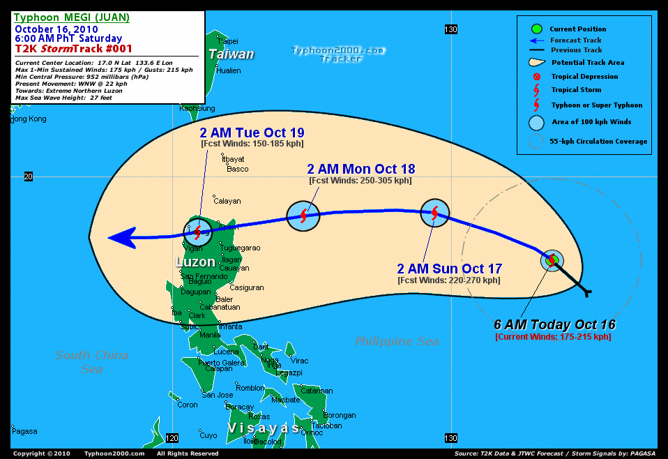
Time/Date: 6:00 AM PhT Sat Oct 16 2010
Location of Center: 17.0º N Lat 133.6º E Lon
Distance 1: 1,175 km (635 nm) ENE of Metro Naga/CWC
Distance 2: 1,230 km (665 nm) ENE of Casiguran, Aurora
Distance 3: 1,265 km (583 nm) ESE of Tuguegarao City
Distance 4: 1,375 km (743 nm) ENE of Metro Manila
MaxWinds (1-min avg): 175 kph (95 kts) near the center
Peak Wind Gusts: 215 kph (115 kts)
Present Movement: WNW @ 22 kph (12 kts)
Towards: Philippine Sea
24-hr Rain Amounts (near center): 300 mm (Heavy)
Minimum Central Pressure: 952 millibars (hPa)
Saffir-Simpson Typhoon Scale: Category 2
Size (in Diameter): 665 km (360 nm) / Avg/Large
Max Sea Wave Height (near center): 27 ft (8.2 m)
Possible Storm Surge Height: 6-8 ft [1.8-2.6 m]
T2K TrackMap #001 (for Public): 6 AM PhT Sat Oct 16
MEGI's eye still cloud-filled...circulation becoming better organized on all quadrants except the southern part. The storm is expected to resume moving WNW across the warm Philippine Sea for the next 24 hours, before it bends westward through 48 hours. It will become a Major Typhoon (Category 3) today...and further strengthening to Category 4 by early tomorrow morning [2PM OCT 16: 18.0N 131.9E @ 195kph...2AM OCT 17: 18.7N 129.4E @ 220kph]. By Monday early morning, MEGI is forecast to become a Super Typhoon w/ 1-minute sustained winds of 250 km/hr...tracking more slightly WSW-ward...approaching the coast of Cagayan [2AM OCT 18: 18.6N 124.7E @ 250kph]. Projected Landfall Area (Time): Over Escarpada Point, Northern Cagayan...about 75 km East of Aparri at sunset on Monday (approx between 5-6 PM)
Maximum Sustained Winds (1-min. avg) are near 175 km/hr (95 knots) with higher gusts. MEGI is a Category 2 Typhoon on the Saffir-Simpson Tropical Cyclone Scale...continued strengthening is expected through Sunday. Typhoon Force Winds (118 km/hr or more) extend outward up to 55 kilometers (30 nautical miles) from the center...and Tropical Storm Force Winds (62-117 km/hr) extend outward up to 160 kilometers (85 nautical miles). MEGI remains an average-sized tropical cyclone with a diameter of 665 kilometers (360 nautical miles) across.
TUESDAY EARLY MORNING: Downgraded to a Category 1 Typhoon after crossing Cagayan-Apayao Area while moving slightly WSW. Its core over Ilocos Norte-Apayao-Abra Border...40 km ESE of Laoag City [2AM OCT 19: 18.0N 120.9E @ 150kph].
WEDNESDAY EARLY MORNING: Turns more westward while over the South China Sea...regains Category 2 [2AM OCT 20: 17.4N 117.2E @ 160kph].
THURSDAY EARLY MORNING: Movement changes to WNW-ward in the direction of Hainan Island, China...intensifies over the South China Sea [2AM OCT 21: 17.8N 113.8E @ 175kph].
Alternate Forecast Scenario (AFS): There is a possibility that MEGI will track west-northwest towards Batanes and Taiwan -- if the rebuilding of the High Pressure Ridge north of the typhoon will not happen.
*Please be reminded that the Forecast Outlook changes every 6 hours, and the Extended Forecast Track have an average error of 250 km on Day 3...450 km on Day 4...and 650 km on Day 5, while the wind speed forecast error, averages 35 kph per day. Therefore, a turn to the left or right of its future track and changes in its wind speed must be anticipated from time to time.
MEGI's rainbands remain at sea and are not yet affecting any major land areas at this time (click here to view the latest NOAA-CIRA's Wind Analysis). 24-hr total rainfall amounts of 5 up to 150 mm (light to moderate rain) can be expected along its outer and inner bands...with isolated amounts of up to 300 mm (heavy) near the center of MEGI, especially along the northern portion (Click here to view the latest NOAA's eTRaP graphic on the storm's rainfall amount). ![]()
External Links for TY MEGI (15W)
View NOAA-CIRA's Latest Wind Analysis
JTWC Latest Tracking Chart: wp1510.gif
Multi-Agency Forecast TrackMap: Near Real-Time
TSR Wind Probabilities: Current to 120 hrs Ahead
NASA-JAXA TMI Page: Latest Rainrate 01
EORC-JAXA TRMM Page: Latest Rainrate 02
Zoomed Satellite Pic: NOAA's Near Real-Time
Wunderground Animation: 6-12 hr. GIF Loop
*TYPHOON 15W (MEGI), LOCATED APPROXIMATELY 780 NM EAST OF MANILA,
PHILIPPINES, HAS TRACKED NORTHWESTWARD AT 15 KNOTS OVER THE PAST SIX
HOURS. ANIMATED INFRARED (IR) SATELLITE IMAGERY AND A 151719Z AMSU
89 GHZ MICROWAVE IMAGE DEPICT A WELL-DEFINED LOW LEVEL CIRCULATION
CENTER (LLCC) WITH TIGHTLY-CURVED BANDING. ANIMATED WATER VAPOR
IMAGERY CONTINUES TO INDICATE GOOD OVERALL OUTFLOW WITH SOME
IMPROVEMENT ALONG THE NORTHWEST QUADRANT AS THE TUTT LOW, PREVIOUSLY
LOCATED NEAR 20N 130E, BEGINS TO FILL AND MOVE NORTHWESTWARD. THERE
IS GOOD CONFIDENCE IN THE CURRENT POSITION BASED ON THE
AFOREMENTIONED AMSU MICROWAVE IMAGE AND CONCURRENT SATELLITE FIXES
FROM PGTW AND RJTD AT 15/18Z. THE CURRENT INTENSITY OF 95 KNOTS IS
SLIGHTLY HIGHER THEN DVORAK ESTIMATES OF 90 KNOTS FROM PGTW AND RJTD
BASED ON AN IMPROVED BANDING SIGNATURE IN IR IMAGERY OVER THE PAST
06 HOURS. TY 15W IS CURRENTLY TRACKING NORTHWESTWARD ALONG THE
SOUTHWESTERN PERIPHERY OF THE MID-LEVEL SUBTROPICAL RIDGE (STR)
TOWARD A WEAKNESS ASSOCIATED WITH A MAJOR MID-LATITUDE SHORTWAVE
TROUGH. AS THE TROUGH CONTINUES TO PROPAGATE NORTHEASTWARD, THE STR
IS EXPECTED TO REORIENT AND RE-BUILD TO THE WEST ALLOWING THE SYSTEM
TO TURN WESTWARD BETWEEN TAU 24 AND TAU 36. TY 15W IS FORECAST TO
CONTINUE TO INTENSIFY UNDER FAVORABLE UPPER LEVEL AND OCEANIC (HIGH
SST AND HIGH OCEAN HEAT CONTENT) CONDITIONS AS IT APPROACHES LUZON.
TY MEGI IS EXPECTED TO MAKE LANDFALL OVER NORTHERN LUZON BETWEEN TAU
48 AND TAU 72 AT OR NEAR SUPER TYPHOON INTENSITY AND SHOULD WEAKEN
CONSIDERABLY DUE TO INTERACTION WITH THE MOUNTAINOUS TERRAIN OF
LUZON. AFTER TAU 72 TY 15W IS EXPECTED TO RE-EMERGE INTO THE SOUTH
CHINA SEA AT TYPHOON INTENSITY AND TRACK WESTWARD TOWARD HAINAN.
NUMERICAL MODEL GUIDANCE IS IN FAIR AGREEMENT, WITH THE EXCEPTION OF
NOGAPS AND WBAR, WHICH ERRONEOUSLY DRIVE THE SYSTEM POLEWARD INTO
THE LOW TO MID-LEVEL STR SITUATED OVER NORTHEAST ASIA. THIS FORECAST
FAVORS THE EGRR, ECMWF, JGSM, AND GFS TRACKERS WHICH HAVE BEEN
CONSISTENTLY TRACKING THE SYSTEM WESTWARD TOWARD LUZON...(more)
>> MEGI, meaning: Catfish. Name contributed by: RO Korea.
RECENT TYPHOON2000 TRACKING CHART:
RECENT MULTI-AGENCY TROPICAL CYCLONE FORECAST TRACKING CHART:


> Image source: NOAA SATELLITE CENTER
> Image source: Wunderground.com (http://www.wunderground.com/)
____________________________________________________________________________________________________________________
LATEST 24 HR. TOTAL RAINFALL AMOUNTS / ENSEMBLE TROPICAL RAINFALL POTENTIAL (eTRaP):

> Image source: NOAA Satellite & Information Service (http://www.ssd.noaa.gov/PS/TROP/etrap.html)
>> To know the meteorological terminologies and acronyms used on this update visit the ff:
http://typhoon2000.ph/tcterm.htm
http://www.nhc.noaa.gov/aboutgloss.shtml
http://www.srh.noaa.gov/oun/severewx/glossary.php
http://www.srh.weather.gov/fwd/glossarynation.html
http://www.nhc.noaa.gov/acronyms.shtml
__________________________________________________________________________________________
For the complete details on TY MEGI (JUAN)...go visit our website @:
> http://www.typhoon2000.com
> http://www.maybagyo.com
Copyright © 2010 Typhoon2000.com All Rights Reserved

No comments:
Post a Comment