
for Tuesday, 13 July 2010 [12:54 PM PhT]

<<<Typhoon2000.
Get the latest 3-Hrly SMS Storm Alerts on BASYANG!
For more details: Text T2K TYPHOON to
2800 (Globe/TM) | 216 (Smart/TNT) | 2288 (Sun)
*only P2.50 (Smart/Globe) / P2.00 (Sun) per msg received.
powered by: Synermaxx
Typhoon2000 (T2K) NEWS (Tue July 13 2010):
Now issuing 3-hrly advisories on TY CONSON (BASYANG). Meanwhile, those who are automatically subscribed to the T2K ON service of SMART/TNT, we are sorry to announce - that service is currently OFFLINE. Smart tech guys are fixing the problem. For the meantime, kindly use the ON-DEMAND SMS by texting T2K TYPHOON to get the latest info on this approaching storm.
CONSON (BASYANG) MAX WIND SPEED PER AGENCY:
+ USA (JTWC/1-min avg): 130 km/hr
+ Japan (JMA/10-min avg): 110 km/hr
+ Philippines (PAGASA/10-min avg): 120 km/hr
+ Korea (KMA/10-min avg): 120 km/hr
+ Hong Kong (HKO/10-min avg): 110 km/hr
+ Taiwan (CWB/10-min avg): 120 km/hr
+ Beijing (NMC/2-min avg): 120 kph
TYPHOON CONSON [BASYANG/03W/
T2K EMAIL ADVISORY NUMBER 05
12:00 PM PhT (04:00 GMT) Tue 13 July 2010
Source: T2K Analysis/JTWC Warning #007
View: Advisory Archives (2004-2010)
*Residents and visitors along Samar, Bicol Region and Luzon should closely monitor the progress of CONSON (BASYANG).
*Do not use this for life or death decision. This advisory is intended for additional information purposes only. Kindly refer to your country's official weather agency for local warnings, advisories & bulletins.
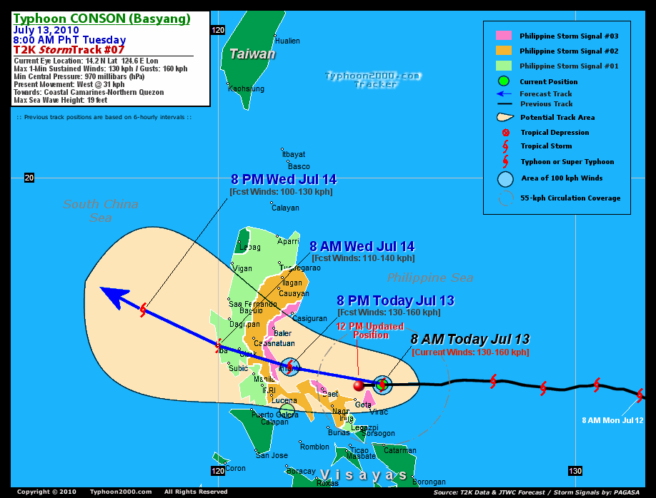
Current Storm Information
Time/Date: 12:00 PM PhT Tue Jul 13 2010
Location of Eye: 14.2º N Lat 124.0º E Lon
Distance 1: 50 km (28 nm) NNE of Gota, Caramoan
Distance 2: 70 km (38 nm) NNW of Virac, Catanduanes
Distance 3: 75 km (40 nm) East of Siruma, Cam. Sur
Distance 4: 110 km (60 nm) NE of Metro Naga/CWC
Distance 5: 120 km (65 nm) East of Daet, Cam. Norte
Distance 6: 125 km (67 nm) NNE of Legazpi City
Distance 7: 255 km (137 nm) ESE of Infanta, Quezon
Distance 8: 315 km (170 nm) ESE of Metro Manila
MaxWinds (1-min avg): 130 kph (70 kts) near the center
Peak Wind Gusts: 160 kph (85 kts)
6-hr Rain Amounts (near the center): 200 mm [Heavy]
Minimum Central Pressure: 970 millibars (hPa)
Saffir-Simpson Typhoon Scale: Category 1
Present Movement: West @ 28 kph (15 kts)
Towards: Northern Quezon-Aurora
Size (in Diameter): 555 km (300 nm) / Average
Max Sea Wave Height (near center): 19 ft (5.7 m)
Coastal Storm Surge Height: 4-5 feet [1.2-1.7 m]
T2K TrackMap #07 (for Public): 12 PM PhT Tue Jul 13
+ Forecast Outlook: CONSON (BASYANG) is expected to pass about 100 km. north of Naga City around 3-4 PM...and about 50 km. north of Daet, Camarines Norte around 5-6 PM today. The eye shall be in the vicinity of Polillo Island around 8-9 PM tonight [8PM JUL 13: 14.7N 122.0E]. CONSON shall make landfall near Infanta, Quezon around 10 PM tonight and cross Central luzon. It shall be in the vicinity of Bulacan early tomorrow morning @ 2 AM or about 50 km. North of Quezon City. It will then move out into the South China Sea or off the coast of Zambales tomorrow morning [8 AM JUL 14: 15.3N 120.0E]. The 3 to 5-Day Long-Range Forecast shows the system downgraded into a Tropical Storm as it turns more to the NW to NNW by Thursday across the South China Sea and shall make its final landfall early Saturday morning along Southern China or just west of Macau [8AM JUL 17: 22.4N 112.2E]. *Alternate Forecast Scenario (AFS): There is a possibility that CONSON will continue tracking Westward and pass less than 50 km. to the north of Naga this afternoon, and traverse the northern tip of Camarines Norte by sunset today -- if the strong, steering High Pressure Ridge which extends east of Taiwan will not weaken. Please be reminded that the Forecast Outlook changes every 6 hours, so a turn to the left or right of its future track and other possibilities must be considered.
+ Effects & Hazards: CONSON's (BASYANG) outer rain bands now covering the whole of Southern Luzon and portions of Central Luzon including Metro Manila, while its Inner rain bands now spreading across the Bicol Region, where strong winds of up to 80 kph can be expected. The Southern Eyewall of CONSON is now affecting Catanduanes and is expected to reach the Northern Coastline of Camarines Provinces later this afternoon through the evening. 6-hr total rainfall amounts of 5 up to 150 mm (light, moderate to heavy rain) can be expected along the outer and inner rainbands...
PAGASA's Philippine Storm Warnings Signals
PHILIPPINE STORM SIGNAL # THREE (3)

Now In Effect: CATANDUANES, CAMARINES NORTE, NORTHERN QUEZON, POLILLO ISLAND, AND AURORA.
PHILIPPINE STORM WARNING SIGNAL # TWO (2)
Now In Effect: CAMARINES SUR, SOUTHERN QUEZON, LAGUNA, RIZAL, BULACAN, N.ECIJA, N.VIZCAYA, QUIRINO, IFUGAO, AND ISABELA.
The above areas will experience stormy weather later today (with winds not exceeding 100 kph for #02) and more than 100 kph for #03). Coastal waters will be rough to very rough and extremely dangerous to all types of seacrafts.
PHILIPPINE STORM WARNING SIGNAL # ONE (1)
Now In Effect: METRO MANILA, REST OF BICOL, REST OF SOUTHERN TAGALOG PROVINCES AND REST OF LUZON (EXCEPT ILOCOS NORTE, MINDORO, & BATANES).
The above areas will have rains and winds of not more than 60 kph can be expected beginning today. Coastal waters will be moderate to rough.
Residents living in low-lying and mountainous areas under Public Storm Warning Signal Numbers 1, 2 & 3 are alerted against flashfloods, mudflows, mudslides and landslides..
External Links for TY CONSON (BASYANG)
View NOAA-CIRA's Latest Wind Analysis
JTWC Latest Tracking Chart: wp0310.gif
Multi-Agency Forecast TrackMap: 11 AM Tue Jul 13
TSR Wind Probabilities: Current to 120 hrs Ahead
Zoomed Satellite Pic: NOAA's Near Real-Time
Wunderground Animation: 6-12 hr. GIF Loop
REMARKS (for Meteorologists): 2 AM (18 GMT) MON 12 JULY POSITION: 14.2N 126.4E.
*TYPHOON (TY) 03W HAS STEADILY INTENSIFIED AND TRACKED DUE WEST-
WARD AT AN AVERAGE SPEED OF 15 KNOTS ALONG THE SOUTHERN PERIPHERY OF
A MID-LEVEL SUBTROPICAL RIDGE TO THE NORTH. ANIMATED MULTISPECTRAL
SATELLITE IMAGERY DEPICTS TIGHTLY WRAPPED DEEP CONVECTION WITH
MODERATE EQUATORIAL OUTFLOW. THE SOUTHWEST FLANK OF THE CYCLONE HAS
BEGUN TO INTERACT WITH THE ISLANDS OF SOUTHERN LUZON. UPPER LEVEL
ANALYSIS INDICATES THE SYSTEM IS WELL SOUTH OF THE RIDGE AXIS IN AN
AREA OF LOW VERTICAL WIND SHEAR (VWS). IN ADDITION TO THE LOW VWS,
HIGH OCEAN HEAT CONTENT (OHC) HAS FUELED THE SYSTEM'S STEADY
INTENSIFICATION. THE CURRENT POSITION IS EXTRAPOLATED FROM A 122256Z
SSMI-S MICROWAVE-EYE FIX WITH HIGH CONFIDENCE..... (more)
>> CONSON, meaning: A historical place. Name contributed by: Vietnam.
____________*TYPHOON (TY) 03W HAS STEADILY INTENSIFIED AND TRACKED DUE WEST-
WARD AT AN AVERAGE SPEED OF 15 KNOTS ALONG THE SOUTHERN PERIPHERY OF
A MID-LEVEL SUBTROPICAL RIDGE TO THE NORTH. ANIMATED MULTISPECTRAL
SATELLITE IMAGERY DEPICTS TIGHTLY WRAPPED DEEP CONVECTION WITH
MODERATE EQUATORIAL OUTFLOW. THE SOUTHWEST FLANK OF THE CYCLONE HAS
BEGUN TO INTERACT WITH THE ISLANDS OF SOUTHERN LUZON. UPPER LEVEL
ANALYSIS INDICATES THE SYSTEM IS WELL SOUTH OF THE RIDGE AXIS IN AN
AREA OF LOW VERTICAL WIND SHEAR (VWS). IN ADDITION TO THE LOW VWS,
HIGH OCEAN HEAT CONTENT (OHC) HAS FUELED THE SYSTEM'S STEADY
INTENSIFICATION. THE CURRENT POSITION IS EXTRAPOLATED FROM A 122256Z
SSMI-S MICROWAVE-EYE FIX WITH HIGH CONFIDENCE..
>> CONSON, meaning: A historical place. Name contributed by: Vietnam.
PAGASA CURRENT POSITION, MOVEMENT AND INTENSITY (10-min. ave.):
> 10 AM (02 GMT) TUE 13 JULY: 14.3N 124.4E / WEST @ 22 kph / 120 kph
:: For the complete PAGASA bulletin, kindly visit their website at:
http://www.pagasa.dost.gov.ph/wb/tcupdate.shtml
_______________________________________________________________________________________________________________________________________
:: For the complete PAGASA bulletin, kindly visit their website at:
http://www.pagasa.
____________
RECENT TYPHOON2000.
________________________
RECENT MTSAT-1R "DAY & NIGHT VISION" SATELLITE IMAGE:

> Image source: NOAA SATELLITE CENTER
RECENT WUNDERGROUND SATELLITE ANIMATION:
***THIS SATELLITE ANIMATION IS ALREADY ALIGNED.***

> Image source: Wunderground.com (http://www.wunderground.com/ ) ____________________________________________________________________________________________________________________
> Image source: NOAA SATELLITE CENTER
____________________________________________________________________________________________________________________
RECENT WUNDERGROUND SATELLITE ANIMATION:
***THIS SATELLITE ANIMATION IS ALREADY ALIGNED.***
> Image source: Wunderground.
LATEST 6 HR. TOTAL RAINFALL AMOUNTS / ENSEMBLE TROPICAL RAINFALL POTENTIAL (eTRaP):

> Image source: NOAA Satellite & Information Service (http://www.ssd.noaa.gov/PS/TROP/etrap.html )____________________________________________________________________________________________________________________
> Image source: NOAA Satellite & Information Service (http://www.ssd.
NOTE:
* - JTWC commentary remarks (for Meteorologists) from their latest warning.
__________________________________________________________________________________________
>> To know the meteorological terminologies and acronyms used on this update visit the ff:
http://typhoon2000.ph/tcterm.htm
http://www.nhc.noaa.gov/aboutgloss.shtml
http://www.srh.noaa.gov/oun/severewx/glossary.php
http://www.srh.weather.gov/fwd/glossarynation.html
http://www.nhc.noaa.gov/acronyms.shtml
__________________________________________________________________________________________
For the complete details on TY CONSON (BASYANG)...go visit our website @:
> http://www.typhoon2000.com
> http://www.maybagyo.com
>> To know the meteorological terminologies and acronyms used on this update visit the ff:
http://typhoon2000.
http://www.nhc.
http://www.srh.
http://www.srh.
http://www.nhc.
____________
>
> http://www.maybagyo
Copyright © 2010 Typhoon2000.
__._,_.___
MARKETPLACE
.
__,_._,___

No comments:
Post a Comment