
for Wednesday, 24 March 2010 [6:41 PM PhT]


<<<Typhoon2000.com Mobile >>>
Get the latest 6-Hrly SMS Storm Alerts on AGATON!
For more details: Text T2K TYPHOON to
2800 (Globe/TM) | 216 (Smart/TNT) | 2288 (Sun)
*only P2.50 (Smart/Globe) / P2.00 (Sun) per msg received.
powered by: Synermaxx
Typhoon2000 (T2K) NEWS (Wed March 24 2010):
Currently issuing 6-hrly advisories (except 12 AM PhT) on TS 02W (AGATON).
02W (AGATON) MAX WIND SPEED PER AGENCY:
+ USA (JTWC/1-min avg): 65 km/hr
+ Japan (JMA/10-min avg): 55 km/hr
+ Philippines (PAGASA/10-min avg): 55 km/hr
TROPICAL STORM 02W [AGATON]
T2K E-MAIL ADVISORY NUMBER 008
6:00 PM PhT (10:00 GMT) Wed 24 March 2010
Source: T2K Analysis/JTWC Warning #011
View: Advisory Archives (2004-2010)
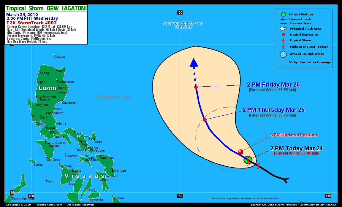
Tropical Storm 02W (AGATON) has slowed down as it enters the Central Philippine Sea...remains a small system.
*Do not use this for life or death decision. This advisory is intended for additional information purposes only. Kindly refer to your country's official weather agency for local warnings, advisories & bulletins.
Current Storm Information
Time/Date: 6:00 PM PhT Wed Mar 24 2010
Location of Center: 12.8º N Lat 134.1º E Lon
Distance 1: 955 km (515 nm) ENE of Borongan, E.Samar
Distance 2: 1,075 km (580 nm) ESE of Virac, Catanduanes
Distance 3: 1,120 km (605 nm) ESE of Gota, Caramoan
Distance 4: 1,185 km (640 nm) ESE of Naga City
MaxWinds (1-min avg): 65 kph (35 kts) near the center
Peak Wind Gusts: 85 kph (45 kts)
6-hr Rain Amounts (near the center): 180 mm [Heavy]
Minimum Central Pressure: 996 millibars (hPa)
Saffir-Simpson Typhoon Scale: TS
Present Movement: WNW @ 15 kph (08 kts)
Towards: Central Philippine Sea
Size (in Diameter): 320 km (170 nm) / Small
Max Sea Wave Height (near center): 18 ft (5.4 m)
Coastal Storm Surge Height: 0-3 feet [0-0.9 m]
T2K TrackMap #02 (for Public): 6 PM PhT Wed Mar 24
+ Forecast Outlook: 02W (AGATON) is expected to continue moving WNW to NW-ward within 24 hours across the central part of the Philippine Sea [2AM MAR 25: 13.4N 132.9E]. It will be downgraded into a Tropical Depression (TD) tomorrow afternoon [2PM MAR 25: 14.9N 131.7E...about 800 km ENE of Bicol Region]. The 2-day Short-Range Forecast shows 02W turning NNW-ward as it dissipates into a Tropical Disturbance (LPA) on Friday afternoon [2PM MAR 26: 17.1N 131.1E...about 915 km East of Casiguran, Aurora] due to unfavorable atmospheric environment (eg. increased upper-level winds, cooler SST) affecting the system. Majority of Global Forecast Guidance Models agree on this scenario. Please be reminded that the Forecast Outlook changes every 6 hours, so a turn to the left or right of its future track and other possibilities must be considered.
+ Effects & Hazards: 02W's rainbands remain over the ocean...no effects & hazards are in place. 6-hr total rainfall amounts of 5 up to 100 mm (light to moderate rain) can be expected along the outer and inner bands...with isolated amounts of up to 180 mm (heavy rain) near the center of 02W. Click here to view the latest NOAA's eTRaP graphic on the storm's rainfall amount.
[Important Note: Please keep in mind that the above forecast outlook, effects, current monsoon intensity, & tropical cyclone watch changes every 6 to 12 hrs!]
External Links for TS 02W (AGATON)
View NOAA-CIRA's Latest Wind Analysis
JTWC Latest Tracking Chart: wp0210.gif
TSR Wind Probabilities: Current to 2-days Ahead
Zoomed Satellite Pic: NOAA's Near Real-Time
Wunderground Animation: 6-12 hr. GIF Loop
JTWC (US NAVY / AIR FORCE) 12, 24, & 48 HR. FORECAST & REMARKS:
2 AM (18 GMT) 25 MARCH: 13.4N 132.9E / 65-85 KPH (TS) / NW @ 17 KPH
2 PM (06 GMT) 25 MARCH: 14.9N 131.7E / 55-75 KPH (TD) / NNW @ 13 KPH
2 PM (06 GMT) 26 MARCH: 17.1N 131.1E / 35-55 KPH (LPA)
<<<Typhoon2000.
Get the latest 6-Hrly SMS Storm Alerts on AGATON!
For more details: Text T2K TYPHOON to
2800 (Globe/TM) | 216 (Smart/TNT) | 2288 (Sun)
*only P2.50 (Smart/Globe) / P2.00 (Sun) per msg received.
powered by: Synermaxx
Typhoon2000 (T2K) NEWS (Wed March 24 2010):
Currently issuing 6-hrly advisories (except 12 AM PhT) on TS 02W (AGATON).
02W (AGATON) MAX WIND SPEED PER AGENCY:
+ USA (JTWC/1-min avg): 65 km/hr
+ Japan (JMA/10-min avg): 55 km/hr
+ Philippines (PAGASA/10-min avg): 55 km/hr
TROPICAL STORM 02W [AGATON]
T2K E-MAIL ADVISORY NUMBER 008
6:00 PM PhT (10:00 GMT) Wed 24 March 2010
Source: T2K Analysis/JTWC Warning #011
View: Advisory Archives (2004-2010)
*Do not use this for life or death decision. This advisory is intended for additional information purposes only. Kindly refer to your country's official weather agency for local warnings, advisories & bulletins.
Current Storm Information
Time/Date: 6:00 PM PhT Wed Mar 24 2010
Location of Center: 12.8º N Lat 134.1º E Lon
Distance 1: 955 km (515 nm) ENE of Borongan, E.Samar
Distance 2: 1,075 km (580 nm) ESE of Virac, Catanduanes
Distance 3: 1,120 km (605 nm) ESE of Gota, Caramoan
Distance 4: 1,185 km (640 nm) ESE of Naga City
MaxWinds (1-min avg): 65 kph (35 kts) near the center
Peak Wind Gusts: 85 kph (45 kts)
6-hr Rain Amounts (near the center): 180 mm [Heavy]
Minimum Central Pressure: 996 millibars (hPa)
Saffir-Simpson Typhoon Scale: TS
Present Movement: WNW @ 15 kph (08 kts)
Towards: Central Philippine Sea
Size (in Diameter): 320 km (170 nm) / Small
Max Sea Wave Height (near center): 18 ft (5.4 m)
Coastal Storm Surge Height: 0-3 feet [0-0.9 m]
T2K TrackMap #02 (for Public): 6 PM PhT Wed Mar 24
+ Forecast Outlook: 02W (AGATON) is expected to continue moving WNW to NW-ward within 24 hours across the central part of the Philippine Sea [2AM MAR 25: 13.4N 132.9E]. It will be downgraded into a Tropical Depression (TD) tomorrow afternoon [2PM MAR 25: 14.9N 131.7E...about 800 km ENE of Bicol Region]. The 2-day Short-Range Forecast shows 02W turning NNW-ward as it dissipates into a Tropical Disturbance (LPA) on Friday afternoon [2PM MAR 26: 17.1N 131.1E...about 915 km East of Casiguran, Aurora] due to unfavorable atmospheric environment (eg. increased upper-level winds, cooler SST) affecting the system. Majority of Global Forecast Guidance Models agree on this scenario. Please be reminded that the Forecast Outlook changes every 6 hours, so a turn to the left or right of its future track and other possibilities must be considered.
+ Effects & Hazards: 02W's rainbands remain over the ocean...no effects & hazards are in place. 6-hr total rainfall amounts of 5 up to 100 mm (light to moderate rain) can be expected along the outer and inner bands...with isolated amounts of up to 180 mm (heavy rain) near the center of 02W. Click here to view the latest NOAA's eTRaP graphic on the storm's rainfall amount.
[Important Note: Please keep in mind that the above forecast outlook, effects, current monsoon intensity, & tropical cyclone watch changes every 6 to 12 hrs!]
External Links for TS 02W (AGATON)
View NOAA-CIRA's Latest Wind Analysis
JTWC Latest Tracking Chart: wp0210.gif
TSR Wind Probabilities: Current to 2-days Ahead
Zoomed Satellite Pic: NOAA's Near Real-Time
Wunderground Animation: 6-12 hr. GIF Loop
2 AM (18 GMT) 25 MARCH: 13.4N 132.9E / 65-85 KPH (TS) / NW @ 17 KPH
2 PM (06 GMT) 25 MARCH: 14.9N 131.7E / 55-75 KPH (TD) / NNW @ 13 KPH
2 PM (06 GMT) 26 MARCH: 17.1N 131.1E / 35-55 KPH (LPA)
REMARKS (for Meteorologists)
*ANIMATED MULTISPECTRAL SATELLITE IMAGERY SHOWS THE LOW LEVEL
CIRCULATION CENTER (LLCC) REMAINS PARTIALLY EXPOSED AND DECOUPLED
FROM THE MAIN CONVECTION TO THE NORTHWEST DUE TO MODERATE
SOUTHEASTERLY VERTICAL WIND SHEAR (VWS). HOWEVER, UPPER LEVEL
ANALYSIS INDICATES THE SYSTEM IS LOCATED NEAR THE SUBTROPICAL RIDGE
AXIS THAT IS ENHANCING A POLEWARD OUTFLOW. THE CURRENT POSITION IS
BASED ON THE ABOVE SATELLITE ANIMATION AND THE CURRENT INTENSITY IS
BASED ON DVORAK ESTIMATES FROM PGTW AND KNES OF T2.5. TS 02W IS
FORECAST TO CONTINUE TRACKING ALONG THE SOUTHWESTERN PERIPHERY OF A
LOW- TO MID-LEVEL SUBTROPICAL STEERING RIDGE THROUGHOUT THE FORECAST
PERIOD. AN UPPER LEVEL TROUGH IS PREDICTED TO WEAKEN THIS STEERING
RIDGE AND ALLOW TS 02W TO TURN MORE POLEWARD AFTER 12 HRS. THE TROUGH
WILL ALSO CAUSE AN INCREASE IN VWS THAT WILL BEGIN WEAKENING THE
SYSTEM AFTER 24 HRS. THE SYSTEM WILL THEN FULLY DISSIPATE AS A
SIGNIFICANT TROPICAL CYCLONE OVER WATER BY 48 HRS. THE NUMERICAL
MODELS ARE IN AGREEMENT WITH THE TURN NORTHWARD AND ALSO INDICATE THE
SYSTEM WILL RE-CURVE INTO THE MID-LATITUDE WESTERLIES. THE FORECAST
TRACK IS GENERALLY IN AGREEMENT WITH THE NUMERICAL MODEL CONSENSUS
THROUGH 36 HOURS WHILE THE FORECAST INTENSITY IS LOWER THAN THE MODEL
GUIDANCE DUE TO THE EVIDENT VWS AND FORECASTED DISSIPATION BEFORE THE
SYSTEM CAN TURN INTO THE MID-LATITUDES.
____________
____________
RECENT TYPHOON2000.
________________________
RECENT MTSAT-1R "DAY & NIGHT VISION" SATELLITE IMAGE:

> Image source: NOAA SATELLITE CENTER
RECENT WUNDERGROUND SATELLITE ANIMATION:

> Image source: Wunderground.com (http://www.wunderground.com/ ) ____________________________________________________________________________________________________________________
> Image source: NOAA SATELLITE CENTER
____________________________________________________________________________________________________________________
RECENT WUNDERGROUND SATELLITE ANIMATION:
> Image source: Wunderground.
LATEST 6 HR. TOTAL RAINFALL AMOUNTS / ENSEMBLE TROPICAL RAINFALL POTENTIAL (eTRaP):

> Image source: NOAA Satellite & Information Service (http://www.ssd.noaa.gov/PS/TROP/etrap.html )____________________________________________________________________________________________________________________
> Image source: NOAA Satellite & Information Service (http://www.ssd.
NOTE:
* - JTWC commentary remarks (for Meteorologists) from their latest warning.
__________________________________________________________________________________________
>> To know the meteorological terminologies and acronyms used on this update visit the ff:
http://typhoon2000.ph/tcterm.htm
http://www.nhc.noaa.gov/aboutgloss.shtml
http://www.srh.noaa.gov/oun/severewx/glossary.php
http://www.srh.weather.gov/fwd/glossarynation.html
http://www.nhc.noaa.gov/acronyms.shtml
__________________________________________________________________________________________
For the complete details on TS 02W (AGATON)...go visit our website @:
> http://www.typhoon2000.com
> http://www.maybagyo.com
>> To know the meteorological terminologies and acronyms used on this update visit the ff:
http://typhoon2000.
http://www.nhc.
http://www.srh.
http://www.srh.
http://www.nhc.
____________
> http://www.typhoon2
> http://www.maybagyo
Copyright © 2010 Typhoon2000.
__._,_.___
.
__,_._,___

No comments:
Post a Comment