
for Wednesday, 25 November 2009 [6:21 AM PST]


<<<Typhoon2000.com Mobile >>>
Get the latest SMS Storm Alerts on URDUJA!
For more details: Text T2K TYPHOON to
2800 (Globe/TM) | Offline (Smart/TNT) | 2288 (Sun)
*only P2.50 (Smart/Globe) / P2.00 (Sun) per msg received.
powered by: Synermaxx
Typhoon2000 (T2K) NEWS (Mon November 23 2009):
Currently issuing 6-hrly Advisories (except 12:00 AM) on TD URDUJA (27W). Meanwhile, our SMS Updates for SMART (216) is currently OFFLINE due to technical problems. Synermaxx and SMART engineers are now fixing the problem which started a few days ago. Please bear with us.
URDUJA (27W) MAX WIND SPEED PER AGENCY:
+ USA (JTWC/1-min avg): 35 km/hr
+ Japan (JMA/10-min avg): 45 km/hr
+ Philippines (PAGASA/10-min avg): 55 km/hr
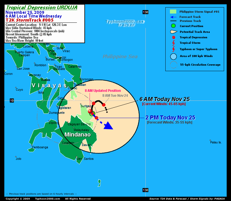
TROPICAL DEPRESSION URDUJA [27W]
T2K PUBLIC ADVISORY NUMBER 006
6:00 AM PST (22:00 GMT) Wed 25 November 2009
Source: T2K Analysis & JTWC/NOAA SatFixes
View: Advisory Archives (2004-2009)
Tropical Depression URDUJA (27W) drifting south and is now along the east coast of Surigao Del Sur, just west of the town of Tandag. Strong and displaced rainbands still affecting Mindanao and Southern Visayas.
*Residents and visitors along Eastern and Central Visayas should closely monitor the progress of URDUJA.
*Do not use this for life or death decision. This advisory is intended for additional information purposes only. Kindly refer to your country's official weather agency for local warnings, advisories & bulletins.
Current Storm Information
Time/Date: 6:00 AM PST Wed Nov 25 2009
Location of Center: 9.1º N Lat 126.3º E Lon
Distance 1: 85 km (45 nm) SSE of Siargao Island
Distance 2: 115 km (62 nm) SE of Surigao City
Distance 3: 280 km (150 nm) ESE of Tagbilaran City
MaxWinds (1-min avg): 45 kph (25 kts) near the center
Peak Wind Gusts: 65 kph (35 kts)
6-hr Rain Amounts (near the center): 250 mm
Minimum Central Pressure: 1004 millibars (hPa)
Saffir-Simpson Typhoon Scale: TD
Present Movement: South @ 05 kph (03 kts)
Towards: Surigao Provinces
Size (in Diameter): 250 km (135 nm) / Small
Max Sea Wave Height (near center): 10 ft (3.0 m)
Coastal Storm Surge Height: 0 feet [0 m]
T2K TrackMap #005 (for Public): 8 AM PST Wed Nov 25
+ Forecast Outlook: URDUJA is expected to continue drifting South to Southeastward along the east coast of Surigao Del Sur within the next 12 to 24 hours. The 12-hr Short-Range Forecast shows the system moving back into the Southern Philippine Sea and dissipate into a tropical disturbance [LPA] (2PM Nov 25: 8.8N 126.6E) - due to increasing vertical wind shear that creates unfavorable conditions across the area. Please be reminded that the Forecast Outlook changes every 6 hours, so a turn to the left or right of its future track and other possibilities must be considered.
+ Effects & Hazards: URDUJA's rainbands remains displaced west of the center, and continues to dump scattered to widespread rains across Mindanao and Southern Visayas. 6-hr total rainfall amounts of 2 up to 150 mm (light to very heavy rain) can be expected along the outer bands...with isolated amounts of 250 mm (very heavy to extreme rain) off its inner bands especially along the coastal areas of Misamis Occidental, Lanao Del Norte and Misamis Oriental. Click here to view the latest NOAA's eTRaP graphic on the storm's rainfall amount. Residents in low-lying areas & steep slopes must remain alert & seek evacuation for possible life-threatening flash floods, mudslides & landslides due to the anticipated heavy rains brought about by this system. Precautionary measures must be initiated if necessary.
[Important Note: Please keep in mind that the above forecast outlook, effects, current monsoon intensity, & tropical cyclone watch changes every 6 to 12 hrs!]
PHILIPPINE STORM WARNING SIGNAL # ONE (1)
In Effect: SOUTHERN LEYTE, SURIGAO DEL NORTE, SURIGAO DEL SUR, AGUSAN DEL NORTE, DINAGAT ISLAND, & SIARGAO ISLAND.
The above areas will have rains and winds of not more than 55 kph today. Coastal waters will be moderate to rough.
Residents living along river banks, low-lying and mountainous areas which are under Public Storm Warning Signal Number 1 are alerted against flashfloods, mudflows, mudslides and landslides.
External Links for TD URDUJA (27W)
View NOAA-CIRA's Latest Wind Analysis
JTWC Latest Tracking Chart: wp9309.gif
Zoomed Satellite Pic: NOAA's Near Real-Time
T2K 12 HR. FORECAST:
2 PM (06 GMT) 25 NOVEMBER: 8.8N 126.6E / 35-55 KPH (LPA) / ... @ .. KPH
__________________________________________________________________________________________________________________________________________________________
<<<Typhoon2000.
Get the latest SMS Storm Alerts on URDUJA!
For more details: Text T2K TYPHOON to
2800 (Globe/TM) | Offline (Smart/TNT) | 2288 (Sun)
*only P2.50 (Smart/Globe) / P2.00 (Sun) per msg received.
powered by: Synermaxx
Typhoon2000 (T2K) NEWS (Mon November 23 2009):
Currently issuing 6-hrly Advisories (except 12:00 AM) on TD URDUJA (27W). Meanwhile, our SMS Updates for SMART (216) is currently OFFLINE due to technical problems. Synermaxx and SMART engineers are now fixing the problem which started a few days ago. Please bear with us.
URDUJA (27W) MAX WIND SPEED PER AGENCY:
+ USA (JTWC/1-min avg): 35 km/hr
+ Japan (JMA/10-min avg): 45 km/hr
+ Philippines (PAGASA/10-min avg): 55 km/hr
TROPICAL DEPRESSION URDUJA [27W]
T2K PUBLIC ADVISORY NUMBER 006
6:00 AM PST (22:00 GMT) Wed 25 November 2009
Source: T2K Analysis & JTWC/NOAA SatFixes
View: Advisory Archives (2004-2009)
*Residents and visitors along Eastern and Central Visayas should closely monitor the progress of URDUJA.
*Do not use this for life or death decision. This advisory is intended for additional information purposes only. Kindly refer to your country's official weather agency for local warnings, advisories & bulletins.
Current Storm Information
Time/Date: 6:00 AM PST Wed Nov 25 2009
Location of Center: 9.1º N Lat 126.3º E Lon
Distance 1: 85 km (45 nm) SSE of Siargao Island
Distance 2: 115 km (62 nm) SE of Surigao City
Distance 3: 280 km (150 nm) ESE of Tagbilaran City
MaxWinds (1-min avg): 45 kph (25 kts) near the center
Peak Wind Gusts: 65 kph (35 kts)
6-hr Rain Amounts (near the center): 250 mm
Minimum Central Pressure: 1004 millibars (hPa)
Saffir-Simpson Typhoon Scale: TD
Present Movement: South @ 05 kph (03 kts)
Towards: Surigao Provinces
Size (in Diameter): 250 km (135 nm) / Small
Max Sea Wave Height (near center): 10 ft (3.0 m)
Coastal Storm Surge Height: 0 feet [0 m]
T2K TrackMap #005 (for Public): 8 AM PST Wed Nov 25
+ Forecast Outlook: URDUJA is expected to continue drifting South to Southeastward along the east coast of Surigao Del Sur within the next 12 to 24 hours. The 12-hr Short-Range Forecast shows the system moving back into the Southern Philippine Sea and dissipate into a tropical disturbance [LPA] (2PM Nov 25: 8.8N 126.6E) - due to increasing vertical wind shear that creates unfavorable conditions across the area. Please be reminded that the Forecast Outlook changes every 6 hours, so a turn to the left or right of its future track and other possibilities must be considered.
+ Effects & Hazards: URDUJA's rainbands remains displaced west of the center, and continues to dump scattered to widespread rains across Mindanao and Southern Visayas. 6-hr total rainfall amounts of 2 up to 150 mm (light to very heavy rain) can be expected along the outer bands...with isolated amounts of 250 mm (very heavy to extreme rain) off its inner bands especially along the coastal areas of Misamis Occidental, Lanao Del Norte and Misamis Oriental. Click here to view the latest NOAA's eTRaP graphic on the storm's rainfall amount. Residents in low-lying areas & steep slopes must remain alert & seek evacuation for possible life-threatening flash floods, mudslides & landslides due to the anticipated heavy rains brought about by this system. Precautionary measures must be initiated if necessary.
[Important Note: Please keep in mind that the above forecast outlook, effects, current monsoon intensity, & tropical cyclone watch changes every 6 to 12 hrs!]
PHILIPPINE STORM WARNING SIGNAL # ONE (1)
In Effect: SOUTHERN LEYTE, SURIGAO DEL NORTE, SURIGAO DEL SUR, AGUSAN DEL NORTE, DINAGAT ISLAND, & SIARGAO ISLAND.
The above areas will have rains and winds of not more than 55 kph today. Coastal waters will be moderate to rough.
Residents living along river banks, low-lying and mountainous areas which are under Public Storm Warning Signal Number 1 are alerted against flashfloods, mudflows, mudslides and landslides.
External Links for TD URDUJA (27W)
View NOAA-CIRA's Latest Wind Analysis
JTWC Latest Tracking Chart: wp9309.gif
Zoomed Satellite Pic: NOAA's Near Real-Time
2 PM (06 GMT) 25 NOVEMBER: 8.8N 126.6E / 35-55 KPH (LPA) / ... @ .. KPH
____________
PAGASA CURRENT POSITION, MOVEMENT AND INTENSITY (10-min. ave.):
> 4 AM (20 GMT) WED 25 NOVEMBER: 9.8N 126.3E / East Slowly / 55 kph
:: For the complete PAGASA bulletin, kindly visit their website at:
http://www.pagasa.dost.gov.ph/wb/tcupdate.shtml
_______________________________________________________________________________________________________________________________________
:: For the complete PAGASA bulletin, kindly visit their website at:
http://www.pagasa.
____________
RECENT TYPHOON2000.
________________________
RECENT MTSAT-1R SATELLITE IMAGE:

> Image source: NOAA SATELLITE CENTER
RECENT WUNDERGROUND SATELLITE ANIMATION:

> Image source: Wunderground.com (http://www.wunderground.com/ ) ____________________________________________________________________________________________________________________
> Image source: NOAA SATELLITE CENTER
____________________________________________________________________________________________________________________
RECENT WUNDERGROUND SATELLITE ANIMATION:
> Image source: Wunderground.
LATEST 6 HR. TOTAL RAINFALL AMOUNTS / ENSEMBLE TROPICAL RAINFALL POTENTIAL (eTRaP):

> Image source: NOAA Satellite & Information Service (http://www.ssd.noaa.gov/PS/TROP/etrap.html?storm=27W )____________________________________________________________________________________________________________________
> Image source: NOAA Satellite & Information Service (http://www.ssd.
NOTE:
^ - JTWC commentary remarks (for Meteorologists) from their latest warning.
__________________________________________________________________________________________
>> To know the meteorological terminologies and acronyms used on this update visit the ff:
http://typhoon2000.ph/tcterm.htm
http://www.nhc.noaa.gov/aboutgloss.shtml
http://www.srh.noaa.gov/oun/severewx/glossary.php
http://www.srh.weather.gov/fwd/glossarynation.html
http://www.nhc.noaa.gov/acronyms.shtml
__________________________________________________________________________________________
For the complete details on TD URDUJA (27W)...go visit our website @:
> http://www.typhoon2000.com
> http://www.maybagyo.com
>> To know the meteorological terminologies and acronyms used on this update visit the ff:
http://typhoon2000.
http://www.nhc.
http://www.srh.
http://www.srh.
http://www.nhc.
____________
> http://www.typhoon2
> http://www.maybagyo
Copyright © 2009 Typhoon2000.
__._,_.___
MARKETPLACE
.
__,_._,___

No comments:
Post a Comment