
Typhoon2000 STORM UPDATE #005
Name: TYPHOON FENGSHEN [FRANK/07W/0806]
Issued: 7:00 AM MANILA TIME (23:00 GMT) SAT 21 JUNE 2008
Source: JTWC TROPICAL CYCLONE WARNING NUMBER 010 / SATFIX
Note: Kindly refer to your country's official warnings or bulletins. This update is for additional information purposes only.
Source: JTWC TROPICAL CYCLONE WARNING NUMBER 010 / SATFIX
Note: Kindly refer to your country's official warnings or bulletins. This update is for additional information purposes only.
_____________________________________________________________________________
TYPHOON FENGSHEN (FRANK) CONTINUES TO INTENSIFY AS IT GRAZES THE NORTHERN
COAST OF PANAY ISLAND...THE EYE IS EXPECTED TO PASS BETWEEN ROMBLON
COAST OF PANAY ISLAND...THE EYE IS EXPECTED TO PASS BETWEEN ROMBLON
AND BORACAY THIS AFTERNOON.
+ FORECAST OUTLOOK: FENGSHEN is expected to pass over or very close to
+ FORECAST OUTLOOK: FENGSHEN is expected to pass over or very close to
Boracay around 12 noon today, before heading towards Mindoro. The Eye
is expected to make landfall over Southern Mindoro late this afternoon
and cross the island. It shall be over the South China Sea by tomorrow
morning.
+ EFFECTS: The Eye of FENGSHEN is now passing along the northern coast
+ EFFECTS: The Eye of FENGSHEN is now passing along the northern coast
Panay with its EyeWall affecting the provinces of Capiz & Aklan inclu-
ding Roxas City. Boracay Island Resort, Tablas Island and Romblon shall
expect the arrival of the EyeWall around 8 AM today. Meanwhile, Its inner
bands continues to spread across the rest of Panay, Northern Negros,
Masbate, Cuyo Is. & Northern Cebu. Strong winds of up to 85 km/hr with
moderate to heavy rains can be expected along the inner bands. Meanwhile,
whole Bicol Region, Metro Manila, Southern Luzon, the whole of Visayas,
Mindoro and Palawan remains under the effects of FENGSHEN's outer (rain)
bands. Moderate to heavy rains with winds not exceeding 40 km/hr can be
expected today. Residents in low-lying areas must seek higher grounds for
possible flooding & landslides due to the anticipated heavy rains brought
about by this system. Precautionary measures must be implemented today.
Coastal Storm Surge flooding of 6 to 8 feet above normal tide levels...
along with large and dangerous battering waves can be expected near and
to the north of FRANK's projected path particularly on where the center
makes landfall in Northern Panay & Mindoro. Moderate damage is possible
on this type of storm surge. Far-fetched storm surge is possible along
coastal areas of Eastern Philippines with surf reaching 2-4 feet at most.
Important Note: Please keep in mind that the above forecast outlook,
effects & current monsoon intensity, and tropical cyclone watch changes
every 06 to 12 hours!
____________
EYEWALL PASSAGE FORECAST TIMES (EPFT):
+ Northern Panay: Ongoing until 2PM today.
+ Romblon-Boracay: 8AM today until 4PM today.
+ Mindoro: 4PM today until 4AM tomorrow.
Note: The EyeWall - is the ring of rain clouds surrounding the "EYE" of a Typhoon. It is here where the
strongest winds and heaviest rain of a typhoon can be found. EPFT will show what local times on a given
area the most damaging winds and heaviest rainfall could be experienced. EPFT changes everytime a
new warning synopsis is issued. Important: This is only an estimate analysis, do not use this for life
or death decisions.
____________
LOCATION OF EYE: LATITUDE 11.8º N...LONGITUDE 123.0º E {Sat Fix}
DISTANCE 1: 30 KM (15 NM) NE OF ROXAS CITY, PH
DISTANCE 2: 80 KM (43 NM) SW OF MASBATE, MASBATE, PH
DISTANCE 3: 120 KM (65 NM) EAST OF BORACAY, PH
DISTANCE 4: 215 KM (115 NM) ESE OF SAN JOSE, OCCIDENTAL MINDORO, PH
DISTANCE 5: 200 KM (108 NM) SSW OF NAGA CITY, PH
DISTANCE 6: 165 KM (90 NM) SW OF LEGAZPI CITY, PH
MAX WINDS [1-MIN AVG]: 165 KM/HR (90 KTS) NEAR THE CENTER
PEAK WIND GUSTS: 205 KM/HR (110 KTS)
SAFFIR-SIMPSON SCALE: CATEGORY TWO (2)
MINIMUM CENTRAL PRESSURE (est.): 956 MILLIBARS (hPa)
RECENT MOVEMENT: WEST @ 13 KM/HR (07 KTS)
GENERAL DIRECTION: BORACAY-ROMBLON AREA
STORM'S SIZE (IN DIAMETER): 555 KM (300 NM)/AVERAGE
MAX WAVE HEIGHT**: 18 FEET (5.4 METERS)
VIEW T2K TRACKING MAP: 5 AM MANILA TIME SAT JUNE 21
TSR WIND PROBABILITIES: CURRENT TO 120 HRS LEAD
PHILIPPINE STORM SIGNALS*:
#03 - BORACAY, LUBANG IS., MINDORO, ROMBLON, MARINDUQUE, BURIAS
IS., CALAMIAN GROUP, AKLAN, NORTHERN ANTIQUE, CAPIZ &
NORTHERN ILOILO.
#02 - LAGUNA, CAVITE, BATANGAS, SOUTHERN QUEZON, CAMARINES SUR,
ALBAY, SORSOGON, NORTHERN PALAWAN, CUYO IS., SAMAR PROVINCES,
BILIRAN IS., LEYTE, REST OF ANTIQUE, REST OF ILOILO, NORTHERN
NEGROS OCCIDENTAL, & NORTHERN CEBU.
ALBAY, SORSOGON, NORTHERN PALAWAN, CUYO IS., SAMAR PROVINCES,
BILIRAN IS., LEYTE, REST OF ANTIQUE, REST OF ILOILO, NORTHERN
NEGROS OCCIDENTAL, & NORTHERN CEBU.
#01 - METRO MANILA, REST OF PALAWAN, BATAAN, ZAMBALES, PAMPANGA,
BULACAN, RIZAL, REST OF QUEZON, POLILLO IS., CAMARINES NORTE,
CATANDUANES, REST OF NEGROS OCCIDENTAL, NEGROS ORIENTAL, REST
OF CEBU, BOHOL, SOUTHERN LEYTE, & DINAGAT IS.
CATANDUANES, REST OF NEGROS OCCIDENTAL, NEGROS ORIENTAL, REST
OF CEBU, BOHOL, SOUTHERN LEYTE, & DINAGAT IS.
12, 24, 48 & 72 HR. FORECAST:
2 PM (06 GMT) 21 JUNE: 12.2N 122.2E / 160-195 KPH / WNW @ 15 KPH
2 AM (18 GMT) 22 JUNE: 12.9N 120.8E / 140-165 KPH / NW @ 15 KPH
2 AM (18 GMT) 23 JUNE: 15.0N 118.4E / 160-195 KPH / NNW @ 15 KPH
2 AM (18 GMT) 24 JUNE: 18.1N 117.1E / 175-215 KPH / NNW @ 15 KPH
REMARKS: 2 AM (18 GMT) 21 JUNE POSITION: 11.6N 123.4E.
^OVER THE PAST 12 HOURS, TY 07W HAS INTENSIFIED SLIGHTLY
WHILE TRACKING STEADILY WEST-NORTHWESTWARD ALONG THE EQUATOR-
WARD PERIPHERY OF A SUBTROPICAL STEERING RIDGE TO THE NORTH.
METSAT DATA INDICATE THAT THE SYSTEM CENTER IS MOVING ACROSS
THE VISAYAN SEA, AMONG THE CENTRAL PHILIPPINE ISLANDS. THE
TYPHOON HAS MAINTAINED A SYMMETRIC STRUCTURE AND DISPLAYS A
RAGID EYE FEATURE DESPITE INCREASING NORTHERLY VERTICAL WIND
SHEAR AND LAND INTERACTION...(more).
>> FENGSHEN {pronounced: feng~shen}, meaning: God of Wind.
Name contributed by: China.
_____________________________________________________________________________
PAGASA CURRENT POSITION, MOVEMENT AND INTENSITY (10-min. ave.):
RECENT T2K TRACKING CHART:
2 AM (18 GMT) 24 JUNE: 18.1N 117.1E / 175-215 KPH / NNW @ 15 KPH
REMARKS: 2 AM (18 GMT) 21 JUNE POSITION: 11.6N 123.4E.
^OVER THE PAST 12 HOURS, TY 07W HAS INTENSIFIED SLIGHTLY
WHILE TRACKING STEADILY WEST-NORTHWESTWARD ALONG THE EQUATOR-
WARD PERIPHERY OF A SUBTROPICAL STEERING RIDGE TO THE NORTH.
METSAT DATA INDICATE THAT THE SYSTEM CENTER IS MOVING ACROSS
THE VISAYAN SEA, AMONG THE CENTRAL PHILIPPINE ISLANDS. THE
TYPHOON HAS MAINTAINED A SYMMETRIC STRUCTURE AND DISPLAYS A
RAGID EYE FEATURE DESPITE INCREASING NORTHERLY VERTICAL WIND
SHEAR AND LAND INTERACTION...(more).
>> FENGSHEN {pronounced: feng~shen}, meaning: God of Wind.
Name contributed by: China.
____________
PAGASA CURRENT POSITION, MOVEMENT AND INTENSITY (10-min. ave.):
> 4 AM (20 GMT) 21 JUNE: 11.9N 123.2E / WNW @ 15 KPH / 140 kph
:: For the complete PAGASA bulletin, kindly visit their website at:
http://www.pagasa.dost.gov.ph/wb/tcupdate.shtml
_____________________________________________________________________________
:: For the complete PAGASA bulletin, kindly visit their website at:
http://www.pagasa.
____________
RECENT T2K TRACKING CHART:

________________________
RECENT MTSAT-1R SATELLITE IMAGE:
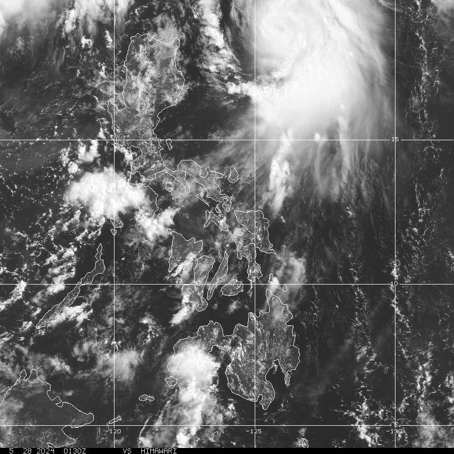
> Image source: NOAA Satellite and Information Service (http://www.goes.noaa.gov/ )
__________________________________________________________________________________________
NOTES:
> Image source: NOAA Satellite and Information Service (http://www.goes.
____________
^ - JTWC commentary remarks (for Meteorologists) from their
latest warning.
latest warning.
* - Based on PAGASA's Philippine Storm Warning Signals,
# 4 being the highest. For more explanations on these
signals, visit: http://www.typhoon2000.ph/signals.htm
** - Based on the Tropical Cyclone's Wave Height near
its center.
__________________________________________________________________________________________
>> To know the meteorological terminologies and acronyms
used on this update visit the ff:
http://typhoon2000.ph/tcterm.htm
http://www.nhc.noaa.gov/aboutgloss.shtml
http://www.srh.noaa.gov/oun/severewx/glossary.php
http://www.srh.weather.gov/fwd/glossarynation.html
http://www.nhc.noaa.gov/acronyms.shtml
__________________________________________________________________________________________
:: Typhoon2000.com (T2K) Mobile >> Powered by: Synermaxx
Receive the latest storm updates directly to your mobile phones! To know more:
Send T2K HELP to: 2800 (GLOBE & TM) | 216 (SMART & TNT) | 2288 (SUN)
Note: Globe & Smart charges P2.50 per message, while Sun at P2.00.
__________________________________________________________________________________________
For the complete details on TY FENGSHEN (FRANK)...go visit
our website @:
> http://www.typhoon2000.com
> http://www.maybagyo.com
# 4 being the highest. For more explanations on these
signals, visit: http://www.typhoon2
** - Based on the Tropical Cyclone's Wave Height near
its center.
____________
>> To know the meteorological terminologies and acronyms
used on this update visit the ff:
http://typhoon2000.
http://www.nhc.
http://www.srh.
http://www.srh.
http://www.nhc.
____________
:: Typhoon2000.
Receive the latest storm updates directly to your mobile phones! To know more:
Send T2K HELP to: 2800 (GLOBE & TM) | 216 (SMART & TNT) | 2288 (SUN)
Note: Globe & Smart charges P2.50 per message, while Sun at P2.00.
For the complete details on TY FENGSHEN (FRANK)...go visit
our website @:
> http://www.typhoon2
> http://www.maybagyo
Copyright © 2008 Typhoon2000.
MARKETPLACE
Attention, Yahoo! Groups users! Sign up now for a one-month free trial from Blockbuster. Limited time offer.
Change settings via the Web (Yahoo! ID required)
Change settings via email: Switch delivery to Daily Digest | Switch format to Traditional
Visit Your Group | Yahoo! Groups Terms of Use | Unsubscribe
.
__,_._,___

No comments:
Post a Comment