
Typhoon2000 STORM UPDATE #009
Name: TROPICAL STORM HALONG [COSME/05W/0804]
Issued: 7:00 AM MANILA TIME (23:00 GMT) SUN 18 MAY 2008
Source: JTWC TROPICAL CYCLONE WARNING NUMBER 010
Note: Kindly refer to your country's official warnings or bulletins. This update is for additional information purposes only.
Source: JTWC TROPICAL CYCLONE WARNING NUMBER 010
Note: Kindly refer to your country's official warnings or bulletins. This update is for additional information purposes only.
_____________________________________________________________________________
HALONG (COSME) WEAKENS INTO A TROPICAL STORM...DUE TO THE EFFECTS
OF LAND INTERACTION AND THE ENTRAINMENT OF DRY AIR FROM THE LUZON
MAINLAND (TAKE NOTE, STORMS GETS THEIR POWER/ENERGY FROM WARM OCEAN
MOIST AIR)...NOW IN THE VICINITY OF KALINGA.
+ FORECAST OUTLOOK: HALONG shall weaken further as it passes over
+ FORECAST OUTLOOK: HALONG shall weaken further as it passes over
Cagayan this morning. It shall be over the Philippine Sea this after-
noon. The 1 to 2-day short range forecast shows the storm reintensi-
fying back to Typhoon strength while passing to the South of Okinawa,
Japan tomorrow afternoon (Monday, May 19). By Tuesday morning, HALONG
shall become Extratropical prior in making its second landfall over
Honshu, Japan on Tuesday afternoon, May 20th.
+ EFFECTS: HALONG's weakening inner and outer rain bands continues to
+ EFFECTS: HALONG's weakening inner and outer rain bands continues to
dump moderate to heavy rains with strong gale-force winds across much
of Northern Luzon. People living in low-lying areas must seek higher
grounds for possible flooding & landslides due to the anticipated heavy
rains brought about by this system. Precautionary measures must remain
fully implemented at this time. Coastal Storm Surge flooding of 1 to 3
feet above normal tide levels...along with large and dangerous battering
waves can be expected near and to the north of HALONG's projected path
particularly when the system returns back to Sea or over Cagayan-Isabela
Coastline. Minimal damage is possible on this type of storm surge.
+ CURRENT MONSOON INTENSITY: Intensified Southwest (SW) Monsoon which is
+ CURRENT MONSOON INTENSITY: Intensified Southwest (SW) Monsoon which is
locally induced by HALONG continues to affect Palawan, Western Visayas
including Boracay Island Resort & Southern Tagalog Provinces. The
monsoon-affected areas will have cloudy skies with light to moderate
rains & SW'ly winds not exceeding 40 km/hr today. Landslides, mudflows
(lahars) and flooding is likely to occur along steep mountain/volcano
slopes, river banks, low-lying & flood-prone areas of the affected areas.
Meanwhile, big sea waves or surges generated by this monsoon can affect
the coastal and beach-front areas of the abovementioned areas. Meanwhile,
the rest of the Philippines is under the active ITCZ (Monsoon Trough),
which will bring scattered rains and thunderstorms most especially in
the afternoon or evening.
Important Note: Please keep in mind that the above forecast outlook,
effects & current monsoon intensity, and tropical cyclone watch changes
every 06 to 12 hours!
_____________________________________________________________________________
TIME/DATE: 5:00 AM MANILA TIME (21:00 GMT) 18 MAY
LOCATION OF CENTER: LATITUDE 17.4º N...LONGITUDE 121.3º E
DISTANCE 1: 50 KM (27 NM) WSW OF TUGUEGARAO CITY, PH
effects & current monsoon intensity, and tropical cyclone watch changes
every 06 to 12 hours!
____________
LOCATION OF CENTER: LATITUDE 17.4º N...LONGITUDE 121.3º E
DISTANCE 1: 50 KM (27 NM) WSW OF TUGUEGARAO CITY, PH
DISTANCE 2: 100 KM (55 NM) ESE OF VIGAN CITY, PH
DISTANCE 3: 115 KM (62 NM) SE OF LAOAG CITY, PH
DISTANCE 4: 115 KM (62 NM) SSW OF APARRI, CAGAYAN, PH
DISTANCE 5: 135 KM (73 NM) NNE OF BAGUIO CITY, PH
DISTANCE 6: 325 KM (175 NM) NORTH OF MANILA, PH
MAX WINDS [1-MIN AVG]: 100 KM/HR (55 KTS) NEAR THE CENTER
PEAK WIND GUSTS: 130 KM/HR (70 KTS)
SAFFIR-SIMPSON SCALE: N/A
MINIMUM CENTRAL PRESSURE (est.): 982 MILLIBARS (hPa)
FORECAST MOVEMENT: NE @ 19 KPH (10 KTS)
GENERAL DIRECTION: CAGAYAN
STORM'S SIZE (IN DIAMETER): 665 KM (360 NM)/AVG/LARGE
MAX WAVE HEIGHT**: .. FEET (... METERS)
VIEW T2K TRACKING MAP: 5 AM MANILA TIME SUN MAY 18
TSR WIND PROBABILITIES: CURRENT TO 72 HOURS LEAD
PHILIPPINE STORM SIGNALS*:
#02 - ILOCOS NORTE, ILOCOS SUR, APAYAO, KALINGA, CAGAYAN, BABUYAN
GROUP OF ISLANDS, ABRA, MT. PROVINCE, ISABELA, NUEVA VIZCAYA,
IFUGAO, QUIRINO, BENGUET, PANGASINAN, & LA UNION.
#01 - ZAMBALES, TARLAC, NUEVA ECIJA, AURORA & BATANES.
12, 24, 48 & 72 HR. FORECAST:
2 PM (06 GMT) 18 MAY: 18.8N 122.7E / 95-120 KPH / NE @ 26 KPH
2 AM (18 GMT) 19 MAY: 20.8N 124.8E / 110-140 KPH / NE @ 39 KPH
2 AM (18 GMT) 20 MAY: 27.8N 131.8E / 100-130 KPH / NNE @ 72 KPH
2 AM (18 GMT) 21 MAY: 40.4N 143.0E / 65-85 KPH / NNE @ 75 KPH
REMARKS: 2 AM (18 GMT) 18 MAY POSITION: 17.0N 120.9E.
^TYPHOON (TY) 05W (HALONG) HAS BEGUN INTERACTING WITH LAND
AS IT IS CURRENTLY LOCATED OFF THE WEST COAST OF THE ISLAND OF
LUZON OVER THE LINGAYEN GULF. THE SYSTEM STEADILY INTENSIFIED
TO AN INTENSITY OF 80 KNOTS (150 KPH) PRIOR TO A BRIEF LANDFALL
OVER CAPE BOLINAO. IT HAS SINCED WEAKENED DUE TO ITS PROXIMITY
TO LAND OVER THE PAST 03 HOURS. RECENT INFRARED SATELLITE
IMAGERY REVEALED THE BRIEF PRESENCE OF AN EYE FEATURE PRIOR
TO LANDFALL...(more)
>> HALONG {pronounced: ha~long}, meaning: A famous picturesque place
in Viet Nam which was claimed heritage by UNESCO, lies in the Bacbo
Gulf and consists of more than 1,000 isles, most of them are lime-
stone islands. Name contributed by: Vietnam.
_____________________________________________________________________________
PAGASA CURRENT POSITION, MOVEMENT AND INTENSITY (10-min. ave.):
REMARKS: 2 AM (18 GMT) 18 MAY POSITION: 17.0N 120.9E.
^TYPHOON (TY) 05W (HALONG) HAS BEGUN INTERACTING WITH LAND
AS IT IS CURRENTLY LOCATED OFF THE WEST COAST OF THE ISLAND OF
LUZON OVER THE LINGAYEN GULF. THE SYSTEM STEADILY INTENSIFIED
TO AN INTENSITY OF 80 KNOTS (150 KPH) PRIOR TO A BRIEF LANDFALL
OVER CAPE BOLINAO. IT HAS SINCED WEAKENED DUE TO ITS PROXIMITY
TO LAND OVER THE PAST 03 HOURS. RECENT INFRARED SATELLITE
IMAGERY REVEALED THE BRIEF PRESENCE OF AN EYE FEATURE PRIOR
TO LANDFALL...(more)
>> HALONG {pronounced: ha~long}, meaning: A famous picturesque place
in Viet Nam which was claimed heritage by UNESCO, lies in the Bacbo
Gulf and consists of more than 1,000 isles, most of them are lime-
stone islands. Name contributed by: Vietnam.
____________
PAGASA CURRENT POSITION, MOVEMENT AND INTENSITY (10-min. ave.):
> 4 AM (20 GMT) 18 MAY: 17.1N 121.0E / NNE @ 13 KPH / 95 kph
:: For the complete PAGASA bulletin, kindly visit their website at:
http://www.pagasa.dost.gov.ph/wb/tcupdate.shtml
_____________________________________________________________________________
RECENT T2K TRACKING CHART:
:: For the complete PAGASA bulletin, kindly visit their website at:
http://www.pagasa.
____________
RECENT T2K TRACKING CHART:

________________________
RECENT MTSAT-1R SATELLITE IMAGE:
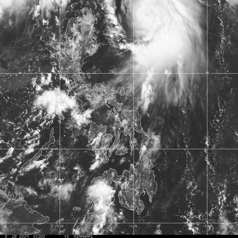
> Image source: NOAA Satellite & Information Service (http://www.goes.noaa.gov/sohemi/ )
__________________________________________________________________________________________
NOTES:
> Image source: NOAA Satellite & Information Service (http://www.goes.
____________
^ - JTWC commentary remarks (for Meteorologists) from their
latest warning.
latest warning.
* - Based on PAGASA's Philippine Storm Warning Signals,
# 4 being the highest. Red letters indicate new areas
being hoisted. For more explanations on these signals,
visit: http://www.typhoon2000.ph/signals.htm
** - Based on the Tropical Cyclone's Wave Height near
its center.
__________________________________________________________________________________________
>> To know the meteorological terminologies and acronyms
used on this update visit the ff:
http://typhoon2000.ph/tcterm.htm
http://www.nhc.noaa.gov/aboutgloss.shtml
http://www.srh.noaa.gov/oun/severewx/glossary.php
http://www.srh.weather.gov/fwd/glossarynation.html
http://www.nhc.noaa.gov/acronyms.shtml
__________________________________________________________________________________________
:: Typhoon2000.com (T2K) Mobile >> Powered by: Synermaxx
Receive the latest storm updates directly to your mobile phones! To know more:
Send T2K HELP to: 2800 (GLOBE & TM) | 216 (SMART & TNT) | 2288 (SUN)
Note: Globe & Smart charges P2.50 per message, while Sun at P2.00.
__________________________________________________________________________________________
For the complete details on TS HALONG (COSME/05W)...go visit
our website @:
> http://www.typhoon2000.com
> http://www.maybagyo.com
# 4 being the highest. Red letters indicate new areas
being hoisted. For more explanations on these signals,
visit: http://www.typhoon2
** - Based on the Tropical Cyclone's Wave Height near
its center.
____________
>> To know the meteorological terminologies and acronyms
used on this update visit the ff:
http://typhoon2000.
http://www.nhc.
http://www.srh.
http://www.srh.
http://www.nhc.
____________
:: Typhoon2000.
Receive the latest storm updates directly to your mobile phones! To know more:
Send T2K HELP to: 2800 (GLOBE & TM) | 216 (SMART & TNT) | 2288 (SUN)
Note: Globe & Smart charges P2.50 per message, while Sun at P2.00.
For the complete details on TS HALONG (COSME/05W).
our website @:
> http://www.typhoon2
> http://www.maybagyo
Copyright © 2008 Typhoon2000.
Change settings via the Web (Yahoo! ID required)
Change settings via email: Switch delivery to Daily Digest | Switch format to Traditional
Visit Your Group | Yahoo! Groups Terms of Use | Unsubscribe
.
__,_._,___

No comments:
Post a Comment