
Typhoon2000 STORM UPDATE #010
Name: TROPICAL DEPRESSION HAGIBIS [LANDO/23W/0724]
Issued: 8:00 AM MANILA TIME (00:00 GMT) THU 29 NOVEMBER 2007
Source: JMA TROPICAL CYCLONE ADVISORY: 27/06UTC
Note: Kindly refer to your country's official warnings or bulletins. This update is for additional information purposes only.
Source: JMA TROPICAL CYCLONE ADVISORY: 27/06UTC
Note: Kindly refer to your country's official warnings or bulletins. This update is for additional information purposes only.
_____________________________________________________________________________
HAGIBIS (LANDO) DOWNGRADED TO A TROPICAL DEPRESSION...DISSPATION
EXPECTED.
**THIS IS THE FINAL UPDATE ON THIS LONG-LIVED SYSTEM.
Important Note: Please keep in mind that the above forecast outlook,
effects & current monsoon intensity, and tropical cyclone watch changes
every 06 to 12 hours!
_____________________________________________________________________________
TIME/DATE: 2:00 PM MANILA TIME (06:00 GMT) 28 NOVEMBER
LOCATION OF CENTER: LATITUDE 15.0º N...LONGITUDE 126.0º E
DISTANCE 1: 250 KM (135 NM) NE OF VIRAC, CATANDUANES, PH
effects & current monsoon intensity, and tropical cyclone watch changes
every 06 to 12 hours!
____________
LOCATION OF CENTER: LATITUDE 15.0º N...LONGITUDE 126.0º E
DISTANCE 1: 250 KM (135 NM) NE OF VIRAC, CATANDUANES, PH
DISTANCE 2: 340 KM (185 NM) ENE OF NAGA CITY, PH
MAX WINDS [10-MIN AVG]: 45 KM/HR (25 KTS) NEAR THE CENTER
PEAK WIND GUSTS: 65 KM/HR (35 KTS)
SAFFIR-SIMPSON SCALE: N/A
MINIMUM CENTRAL PRESSURE (est.): 1004 MILLIBARS (hPa)
RECENT MOVEMENT: ENE @ 07 KM/HR (04 KTS)
GENERAL DIRECTION: PHILIPPINE SEA
STORM'S SIZE (IN DIAMETER): 610 KM (330 NM)/AVERAGE
MAX WAVE HEIGHT**: 10 FEET (3.0 METERS)
VIEW T2K TRACKING MAP: 11 AM MANILA TIME WED NOVEMBER 28
TSR WIND PROBABILITIES: CURRENT TO 24 HRS LEAD
PHILIPPINE STORM SIGNALS*: None
_____________________________________________________________________________
_____________________________________________________________________________
RECENT T2K TRACKING CHART:
____________
RECENT T2K TRACKING CHART:

________________________
RECENT MTSAT-1R SATELLITE IMAGE:
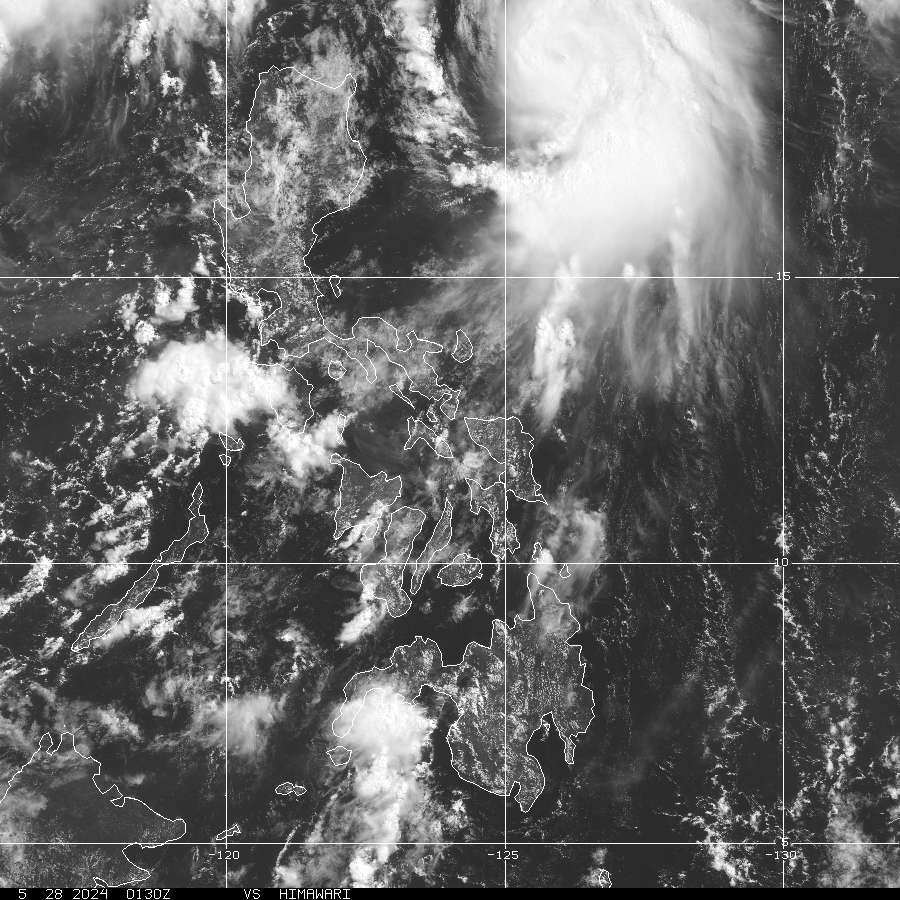
> Image source: NOAA
__________________________________________________________________________________________
NOTES:
> Image source: NOAA
____________
^ - JTWC commentary remarks (for Meteorologists) from their
latest warning.
latest warning.
* - Based on PAGASA's Philippine Storm Warning Signals,
# 4 being the highest. Red letters indicate new areas
being hoisted. For more explanations on these signals,
visit: http://www.typhoon2000.ph/signals.htm
** - Based on the Tropical Cyclone's Wave Height near
its center.
__________________________________________________________________________________________
>> To know the meteorological terminologies and acronyms
used on this update visit the ff:
http://typhoon2000.ph/tcterm.htm
http://www.nhc.noaa.gov/aboutgloss.shtml
http://www.srh.noaa.gov/oun/severewx/glossary.php
http://www.srh.weather.gov/fwd/glossarynation.html
http://www.nhc.noaa.gov/acronyms.shtml
__________________________________________________________________________________________
:: Typhoon2000.com (T2K) Mobile >> Powered by: Synermaxx
Receive the latest storm updates directly to your mobile phones! To know more:
Send T2K HELP to: 2800 (GLOBE & TM) | 216 (SMART & TNT) | 2288 (SUN)
Note: Globe & Smart charges P2.50 per message, while Sun at P2.00.
__________________________________________________________________________________________
For the complete details on TD HAGIBIS (LANDO)...go visit
our website @:
> http://www.typhoon2000.com
> http://www.maybagyo.com
# 4 being the highest. Red letters indicate new areas
being hoisted. For more explanations on these signals,
visit: http://www.typhoon2
** - Based on the Tropical Cyclone's Wave Height near
its center.
____________
>> To know the meteorological terminologies and acronyms
used on this update visit the ff:
http://typhoon2000.
http://www.nhc.
http://www.srh.
http://www.srh.
http://www.nhc.
____________
:: Typhoon2000.
Receive the latest storm updates directly to your mobile phones! To know more:
Send T2K HELP to: 2800 (GLOBE & TM) | 216 (SMART & TNT) | 2288 (SUN)
Note: Globe & Smart charges P2.50 per message, while Sun at P2.00.
For the complete details on TD HAGIBIS (LANDO)...go visit
our website @:
> http://www.typhoon2
> http://www.maybagyo
Change settings via the Web (Yahoo! ID required)
Change settings via email: Switch delivery to Daily Digest | Switch format to Traditional
Visit Your Group | Yahoo! Groups Terms of Use | Unsubscribe
.
__,_._,___

No comments:
Post a Comment