Typhoon2000 STORM UPDATE #008
Name: TROPICAL STORM LEKIMA [HANNA/16W/0714]
Issued: 7:00 AM MANILA TIME (23:00 GMT) MON 01 OCTOBER 2007
Next Update: 7:00 PM (11:00 GMT) MON 01 OCTOBER
Source: JTWC TROPICAL CYCLONE WARNING NUMBER 004
Note: Kindly refer to your country's official warnings or bulletins. This update is for additional information purposes only.
Next Update: 7:00 PM (11:00 GMT) MON 01 OCTOBER
Source: JTWC TROPICAL CYCLONE WARNING NUMBER 004
Note: Kindly refer to your country's official warnings or bulletins. This update is for additional information purposes only.
_____________________________________________________________________________
TROPICAL STORM LEKIMA (HANNA) STRENGTHENED MORE WHILE MOVING SLOWLY
OVER THE SOUTH CHINA SEA...AIMING FOR THE GULF OF TONKIN AND NORTHERN
VIETNAM.OVER THE SOUTH CHINA SEA...AIMING FOR THE GULF OF TONKIN AND NORTHERN
+ FORECAST OUTLOOK: LEKIMA is expected to move West to WNW across the
South China Sea for the next 12 hours before turning sharply NW'ly. It
is likely to become a Typhoon this afternoon. The 2 to 4-day forecast
shows LEKIMA passing just to the SW of Hainan Island around tomorrow
morning, bringing typhoon conditions to the southern part of island.
Upon moving into the Gulf of Tonkin and reaching its peak winds of
150 km/hr, LEKIMA shall resume its WNW track until its landfall over
North-Central Vietnam early Thursday morning, Oct 04. LEKIMA shall be
downgraded into a Tropical Storm upon crossing the terrain of North
Vietnam, dissipating on Friday morning Oct 05 over Laos.
+ EFFECTS: LEKIMA's inner rain bands continues to expand but remains
+ EFFECTS: LEKIMA's inner rain bands continues to expand but remains
over the South China Sea near the coast of Central Vietnam, however,
the NW, Western and SW outer bands continues to spread across Central
& Southern Vietnam, Hainan and portions of Myanmar, Laos & Cambodia.
Cloudy skies with passing light to moderate and sometimes heavy
downpour can be expected along Lekima's outer bands...becoming more
intense and windy as the inner bands moves through. Flash floods and
mudslides are imminent along river banks, low-lying and mountainous
Monsoon enhanced by a new strong Tropical Disturbance (LPA) over the
Philippine Sea - will continue to bring cloudy skies with "on & off"
rains & South to SW'ly winds of 20 km/hr or higher across Western
Philippines becoming more frequent over NCR, Western portions of
Central Luzon, Western Visayas, Southern Luzon and Bicol Region.
Landslides and flooding is likely to occur along steep mountain
slopes, river banks, low-lying & flood-prone areas of the
affected areas.
+ TROPICAL CYCLONE WATCH: A new and strong Tropical Disturbance
+ TROPICAL CYCLONE WATCH: A new and strong Tropical Disturbance
(LPA/91W/1006 MB) has been observed developing over the Philippine
Sea, some 900 km East of Casiguran, Aurora (15.9N 130.6E)...barely
moving...with max sustained winds of 30 km/hr. This system may become
a Tropical Cyclone within a day or two as depicted on almost all of the
computer forecast models. Watch for more updates on this newly-formed
disturbance.
Important Note: Please keep in mind that the above forecast outlook,
effects & current monsoon intensity, and tropical cyclone watch changes
every 06 to 12 hours!
_____________________________________________________________________________
TIME/DATE: 5:00 AM MANILA TIME (21:00 GMT) 01 OCTOBER
LOCATION OF CENTER: LATITUDE 14.7º N...LONGITUDE 113.0º E
DISTANCE 1: 535 KM (290 NM) ESE OF DA NANG, VIETNAM
effects & current monsoon intensity, and tropical cyclone watch changes
every 06 to 12 hours!
____________
LOCATION OF CENTER: LATITUDE 14.7º N...LONGITUDE 113.0º E
DISTANCE 1: 535 KM (290 NM) ESE OF DA NANG, VIETNAM
DISTANCE 2: 610 KM (330 NM) ESE OF HUE, VIETNAM
DISTANCE 3: 540 KM (292 NM) SE OF SANYA, HAINAN IS.
DISTANCE 4: 565 KM (305 NM) SSE OF QIONGHAI, HAINAN IS.
DISTANCE 5: 870 KM (470 NM) WEST OF METRO MANILA, PH
PEAK WIND GUSTS: 130 KM/HR (70 KTS)
SAFFIR-SIMPSON SCALE: N/A
MINIMUM CENTRAL PRESSURE (est.): 982 MILLIBARS (hPa)
RECENT MOVEMENT: WEST @ 07 KM/HR (04 KTS)
GENERAL DIRECTION: GULF OF TONKIN-VIETNAM AREA
STORM'S SIZE (IN DIAMETER): 835 KM (450 NM)/LARGE
MAX WAVE HEIGHT**: 20 FEET (6.0 METERS)
VIEW TRACKING MAP: 2 AM HONG KONG TIME MON OCTOBER 01
TSR WIND PROBABILITIES: CURRENT TO 96 HRS LEAD
PHILIPPINE STORM SIGNALS*: N/A
12, 24 & 48 HR. FORECAST:
2 PM (06 GMT) 01 OCTOBER: 15.0N 112.2E / 120-150 KPH / NW @ 11 KPH
2 AM (18 GMT) 02 OCTOBER: 15.8N 111.3E / 140-165 KPH / NW @ 11 KPH
2 AM (18 GMT) 03 OCTOBER: 17.3N 109.3E / 150-185 KPH / WNW @ 15 KPH
REMARKS: 2 AM (18 GMT) 01 OCTOBER POSITION: 14.6N 113.3E.
^TROPICAL STORM (TS) 16W (LEKIMA) HAS SEEN INCREASED CONVECTION
NEAR THE LOW LEVEL CIRCULATION CENTER (LLCC), ALTHOUGH IT REMAINS
PARTIALLY EXPOSED. AN UPPER LEVEL LOW JUST TO THE WEST OF LUZON, AND
EAST OF TS 16W SEEMS TO BE INHIBITING DEEP CONVECTION FROM FORMING
DIRECTLY OVER THE LLCC. TO THE WEST OF THE UPPER LEVEL LOW IS AN
AREA OF EXCELLENT DIFFLUENCE ALOFT, WHICH IS AIDING CONVECTION ON
THE WESTERN SIDE OF THE STORM. OVER THE PAST 06 HOURS, ANIMATED
INFRARED IMAGERY HAS SHOWN SOME SIGNS OF A BANDING EYE BEGINNING TO
DEVELOP. THE STORM HAS TRACKED WEST-SOUTHWESTWARD ON THE SOUTHERN
PERIPHERY OF A RIDGE EXTENDING FROM SHANGHAI ACROSS SOUTHEASTERN
CHINA...(more)
_____________________________________________________________________________
REMARKS: 2 AM (18 GMT) 01 OCTOBER POSITION: 14.6N 113.3E.
^TROPICAL STORM (TS) 16W (LEKIMA) HAS SEEN INCREASED CONVECTION
NEAR THE LOW LEVEL CIRCULATION CENTER (LLCC), ALTHOUGH IT REMAINS
PARTIALLY EXPOSED. AN UPPER LEVEL LOW JUST TO THE WEST OF LUZON, AND
EAST OF TS 16W SEEMS TO BE INHIBITING DEEP CONVECTION FROM FORMING
DIRECTLY OVER THE LLCC. TO THE WEST OF THE UPPER LEVEL LOW IS AN
AREA OF EXCELLENT DIFFLUENCE ALOFT, WHICH IS AIDING CONVECTION ON
THE WESTERN SIDE OF THE STORM. OVER THE PAST 06 HOURS, ANIMATED
INFRARED IMAGERY HAS SHOWN SOME SIGNS OF A BANDING EYE BEGINNING TO
DEVELOP. THE STORM HAS TRACKED WEST-SOUTHWESTWARD ON THE SOUTHERN
PERIPHERY OF A RIDGE EXTENDING FROM SHANGHAI ACROSS SOUTHEASTERN
CHINA...(more)
____________
_____________________________________________________________________________
RECENT TRACKING CHART:
RECENT TRACKING CHART:
________________________
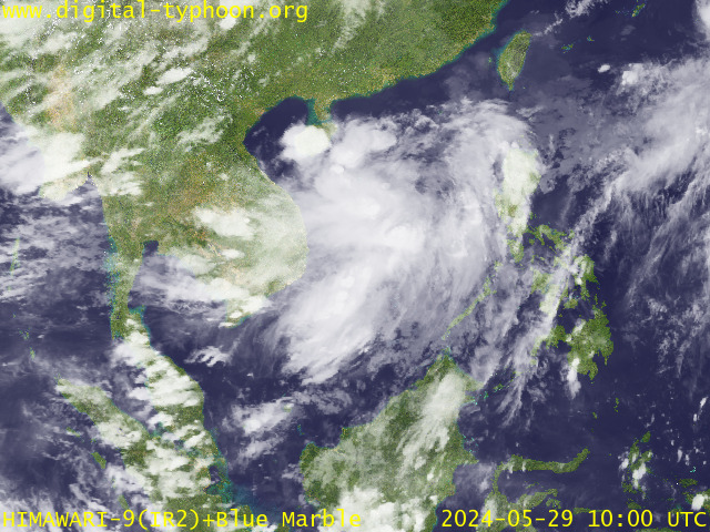
RECENT MTSAT-1R SATELLITE IMAGE:

> Image source: Digital-Typhoon.org (Nat'l. Institute of Informatics) (http://www.digital-typhoon.org )
__________________________________________________________________________________________
NOTES:

> Image source: Digital-Typhoon.
^ - JTWC commentary remarks (for Meteorologists) from their
latest warning.
latest warning.
* - Based on PAGASA's Philippine Storm Warning Signals,
# 4 being the highest. Red letters indicate new areas
being hoisted. For more explanations on these signals,
visit: http://www.typhoon2000.ph/signals.htm
** - Based on the Tropical Cyclone's Wave Height near
its center.
__________________________________________________________________________________________
>> To know the meteorological terminologies and acronyms
used on this update visit the ff:
http://typhoon2000.ph/tcterm.htm
http://www.nhc.noaa.gov/aboutgloss.shtml
http://www.srh.noaa.gov/oun/severewx/glossary.php
http://www.srh.weather.gov/fwd/glossarynation.html
http://www.nhc.noaa.gov/acronyms.shtml
__________________________________________________________________________________________
:: Typhoon2000.com (T2K) Mobile >> Powered by: Synermaxx
Receive the latest storm updates directly to your mobile phones! To know more:
Send T2K HELP to: 2800 (GLOBE & TM) | 216 (SMART & TNT) | 2288 (SUN)
Note: Globe & Smart charges P2.50 per message, while Sun at P2.00.
__________________________________________________________________________________________
For the complete details on TS LEKIMA (HANNA)...go visit
our website @:
> http://www.typhoon2000.com
> http://www.maybagyo.com
# 4 being the highest. Red letters indicate new areas
being hoisted. For more explanations on these signals,
visit: http://www.typhoon2
** - Based on the Tropical Cyclone's Wave Height near
its center.
____________
>> To know the meteorological terminologies and acronyms
used on this update visit the ff:
http://typhoon2000.
http://www.nhc.
http://www.srh.
http://www.srh.
http://www.nhc.
____________
:: Typhoon2000.
Receive the latest storm updates directly to your mobile phones! To know more:
Send T2K HELP to: 2800 (GLOBE & TM) | 216 (SMART & TNT) | 2288 (SUN)
Note: Globe & Smart charges P2.50 per message, while Sun at P2.00.
For the complete details on TS LEKIMA (HANNA)...go visit
our website @:
> http://www.typhoon2
> http://www.maybagyo
Change settings via the Web (Yahoo! ID required)
Change settings via email: Switch delivery to Daily Digest | Switch format to Traditional
Visit Your Group | Yahoo! Groups Terms of Use | Unsubscribe
.
__,_._,___
No comments:
Post a Comment