
Typhoon2000 STORM UPDATE #011 **FINAL**
Name: TROPICAL STORM FITOW [10W/0709]
Issued: 7:00 PM MANILA TIME (11:00 GMT) FRI 07 SEPTEMBER 2007
Source: JTWC TROPICAL CYCLONE WARNING #039 (FINAL)
Source: JTWC TROPICAL CYCLONE WARNING #039 (FINAL)
_______________________________________________________________________
TYPHOON FITOW (10W) BECOMES EXTRATROPICAL AS IT TRAVERSES NOR-
THERN HONSHU AND HOKKAIDO, MOVING IN A FAST NORTH-NORTHEASTTRACK.
*THIS IS THE FINAL UPDATE ON THIS SYSTEM.
+ FORECAST OUTLOOK: FITOW is expected to continue accelerating
*THIS IS THE FINAL UPDATE ON THIS SYSTEM.
+ FORECAST OUTLOOK: FITOW is expected to continue accelerating
NNE'ly to NE'ly across Hokkaido tonight.
+ EFFECTS: FITOW's weakening circulation is expected to conti-
+ EFFECTS: FITOW's weakening circulation is expected to conti-
nue bringing Tropical Storm force winds with rains along the
central and northern portions of Honshu and Hokkaido. Inner
and outer rain bands spreading across other parts of Honshu.
Flash floods and mudslides are imminent along river banks,
low-lying and mountainous regions of the affected areas.
Precautionary measures must be initiated as the powerful
system approaches.
+ TROPICAL CYCLONE WATCH: Meanwhile, the other Tropical
+ TROPICAL CYCLONE WATCH: Meanwhile, the other Tropical
Disturbance (LPA/1006 MB) NW of Wake Island is now Tropical
Depression 11W. Kindly check out the "Other Tropical Cyclone"
link located on the main page. Typhoon2000.ph will not issue
storm updates on this new depression since the system is
over open ocean and is not affecting any Pacific Islands.
Important Note: Please keep in mind that the above forecast
outlook, effects & current monsoon intensity, and tropical
cyclone watch changes every 06 to 12 hours!
_______________________________________________________________________
TIME/DATE: 5:00 PM MANILA TIME (09:00 GMT) 07 SEPTEMBER
LOCATION OF EYE: LATITUDE 40.7º N...LONGITUDE 141.5º E
DISTANCE 1: 255 KM (137 NM) SOUTH OF SAPPORO, JAPAN
Important Note: Please keep in mind that the above forecast
outlook, effects & current monsoon intensity, and tropical
cyclone watch changes every 06 to 12 hours!
____________
TIME/DATE: 5:00 PM MANILA TIME (09:00 GMT) 07 SEPTEMBER
LOCATION OF EYE: LATITUDE 40.7º N...LONGITUDE 141.5º E
DISTANCE 1: 255 KM (137 NM) SOUTH OF SAPPORO, JAPAN
DISTANCE 2: 270 KM (145 NM) NNE OF SENDAI, JAPAN
DISTANCE 3: 580 KM (313 NM) NNE OF TOKYO, JAPAN
DISTANCE 4: 375 KM (203 NM) NE OF NIIGATA, JAPAN
MAX SUSTAINED WINDS [1-MIN AVG]: 85 KM/HR (45 KTS)PEAK WIND GUSTS: 100 KM/HR (55 KTS)
SAFFIR-SIMPSON SCALE: N/A
MINIMUM CENTRAL PRESSURE (est.): 990 MILLIBARS (hPa)
RECENT MOVEMENT: NNE @ 48 KM/HR (26 KTS)
GENERAL DIRECTION: HOKKAIDO, JAPAN
STORM'S SIZE (IN DIAMETER): 775 KM (420 NM)/LARGE
MAX WAVE HEIGHT**: 29 FEET (8.8 METERS)
VIEW TRACKING MAP: 3 PM JAPAN TIME FRI SEPTEMBER 07
TSR WIND PROBABILITIES: CURRENT TO 12 HRS LEAD
PHILIPPINE STORM SIGNALS*: N/A
12 HR. FORECAST:
2 AM (18 GMT) 08 SEPTEMBER: 43.8N 143.6E / 75-95 KPH [ETC]
REMARKS: 2 PM (06 GMT) 07 SEPTEMBER POSITION: 39.6N 140.8E.
^...(more)
>> FITOW {pronounced: fee~tow}, meaning: Yapese name for a
beautiful fragrant flower. Name contributed by: Micronesia.
_______________________________________________________________________
_______________________________________________________________________
RECENT TRACKING CHART:
____________
____________
RECENT TRACKING CHART:
________________________
RECENT MTSAT-1R SATELLITE IMAGE:
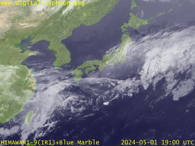
> Image source: Digital-Typhoon.org (Nat'l. Institute of Informatics) (http://www.digital-typhoon.org )
__________________________________________________________________________________________
NOTES:
> Image source: Digital-Typhoon.
^ - JTWC commentary remarks (for Meteorologists) from their
latest warning.
latest warning.
* - Based on PAGASA's Philippine Storm Warning Signals,
# 4 being the highest. Red letters indicate new areas
being hoisted. For more explanations on these signals,
visit: http://www.typhoon2000.ph/signals.htm
** - Based on the Tropical Cyclone's Wave Height near
its center.
__________________________________________________________________________________________
>> To know the meteorological terminologies and acronyms
used on this update visit the ff:
http://typhoon2000.ph/tcterm.htm
http://www.nhc.noaa.gov/aboutgloss.shtml
http://www.srh.noaa.gov/oun/severewx/glossary.php
http://www.srh.weather.gov/fwd/glossarynation.html
http://www.nhc.noaa.gov/acronyms.shtml
__________________________________________________________________________________________
:: Typhoon2000.com (T2K) Mobile >> Powered by: Synermaxx
Receive the latest storm updates directly to your mobile phones! To know more:
Send T2K HELP to: 2800 (GLOBE & TM) | 216 (SMART & TNT) | 2288 (SUN)
Note: Globe & Smart charges P2.50 per message, while Sun at P2.00.
__________________________________________________________________________________________
For the complete details on TS FITOW (10W)...go visit
our website @:
> http://www.typhoon2000.com
> http://www.maybagyo.com
# 4 being the highest. Red letters indicate new areas
being hoisted. For more explanations on these signals,
visit: http://www.typhoon2
** - Based on the Tropical Cyclone's Wave Height near
its center.
____________
>> To know the meteorological terminologies and acronyms
used on this update visit the ff:
http://typhoon2000.
http://www.nhc.
http://www.srh.
http://www.srh.
http://www.nhc.
____________
:: Typhoon2000.
Receive the latest storm updates directly to your mobile phones! To know more:
Send T2K HELP to: 2800 (GLOBE & TM) | 216 (SMART & TNT) | 2288 (SUN)
Note: Globe & Smart charges P2.50 per message, while Sun at P2.00.
For the complete details on TS FITOW (10W)...go visit
our website @:
> http://www.typhoon2
> http://www.maybagyo
Change settings via the Web (Yahoo! ID required)
Change settings via email: Switch delivery to Daily Digest | Switch format to Traditional
Visit Your Group | Yahoo! Groups Terms of Use | Unsubscribe
.
__,_._,___

No comments:
Post a Comment