
Typhoon2000 STORM UPDATE #002
Name: TYPHOON FITOW [10W/0709]
Issued: 7:00 PM MANILA TIME (11:00 GMT) FRI 31 AUGUST 2007
Next Update: 7:00 AM (23:00 GMT) SAT 01 SEPTEMBER
Source: JTWC TROPICAL CYCLONE WARNING #011
Next Update: 7:00 AM (23:00 GMT) SAT 01 SEPTEMBER
Source: JTWC TROPICAL CYCLONE WARNING #011
_______________________________________________________________________
TYPHOON FITOW (10W) HAS TURNED NORTHWEST AS IT REACHED
WIND SPEED OF 150-KM/HR...THREATENS JAPAN.+ FORECAST OUTLOOK: FITOW is expected to continue on its
WNW track in response to a building high pressure steering
ridge situated to the North of Fitow, or just to the East
of Japan. The 2 to 5-day forecast shows the system conti-
nuing moving WNW in the direction of Japan, turning NW'ly
on Tuesday afternoon (Sep 4). It shall reach Category 3
status (205 km/hr) on Wednesday afternoon Sep 5. Initial
Impact Forecast (IIF) calls for a Southern Honshu landfall
on Sep 6.
+ EFFECTS: FITOW's rainbands continues to affect the tiny
+ EFFECTS: FITOW's rainbands continues to affect the tiny
island of Marcus. Increasing winds with rains will continue
to prevail over the island tonight. Coastal Storm Surge
flooding of 04 to 05 feet above normal tide levels...along
with large and dangerous battering waves can be expected
near and to the north of FITOW's projected path particu-
larly along Marcus Island.
+ TROPICAL CYCLONE WATCH: The new Tropical Disturbance
+ TROPICAL CYCLONE WATCH: The new Tropical Disturbance
(LPA/1008 MB) over the South China Sea, or just to the
West of Subic Bay, PH has been drifting Southward during
the past 6 hours and continues to organize. It was estima-
ted about 325 km West of Quezon City (14.7N 118.0E). With
sustained winds of 30 km/hr, this system is showing signs
of developing into a Tropical Depression (TD). Provinces
of Pangasinan, Zambales, Tarlac, Pampanga, Bataan and
Metro Manila can expect rains and thunderstorms tonight
or tomorrow due to its developing outer bands. More up-
dates soon as the system continues to develop. Kindly
check out the latest zoomed satellite pic here.
Important Note: Please keep in mind that the above forecast
outlook, effects & current monsoon intensity, and tropical
cyclone watch changes every 06 to 12 hours!
____________
TIME/DATE: 5:00 PM MANILA TIME (09:00 GMT) 31 AUGUST
LOCATION OF EYE: LATITUDE 27.3º N...LONGITUDE 154.4º E
DISTANCE 1: 370 KM (202 NM) NNW OF MARCUS ISLAND
DISTANCE 2: 1,335 KM (720 NM) ENE OF IWO TO
DISTANCE 3: 1,675 KM (903 NM) SE OF TOKYO
DISTANCE 4: 3,460 KM (1,867 NM) ENE OF LUZON, PH
MAX SUSTAINED WINDS [1-MIN AVG]: 150 KM/HR (80 KTS)DISTANCE 4: 3,460 KM (1,867 NM) ENE OF LUZON, PH
PEAK WIND GUSTS: 185 KM/HR (100 KTS)
SAFFIR-SIMPSON SCALE: CATEGORY ONE (1)
MINIMUM CENTRAL PRESSURE (est.): 963 MILLIBARS (hPa)
RECENT MOVEMENT: NW @ 11 KM/HR (06 KTS)
GENERAL DIRECTION: JAPAN
STORM'S SIZE (IN DIAMETER): 590 KM (320 NM)/AVERAGE
MAX WAVE HEIGHT**: 24 FEET (7.3 METERS)
VIEW TRACKING MAP: 3 PM JAPAN TIME FRI AUGUST 31
TSR WIND PROBABILITIES: CURRENT TO 120 HRS LEAD
PHILIPPINE STORM SIGNALS*: N/A
12, 24 & 48 HR. FORECAST:
2 AM (18 GMT) 01 SEPTEMBER: 27.8N 153.3E / 160-195 KPH / WNW @ 13 KPH
2 PM (06 GMT) 01 SEPTEMBER: 28.4N 151.8E / 165-205 KPH / W @ 13 KPH
2 PM (06 GMT) 02 SEPTEMBER: 28.9N 148.7E / 175-215 KPH / WNW @ 11 KPH
REMARKS: 2 PM (06 GMT) 31 AUGUST POSITION: 27.1N 154.8E.
^TYPHOON (TY) 10W (FITOW) HAS TAKEN A SHARP WESTWARD TURN
DURING THE PAST 12 HOURS AND SLOWED SLIGHTLY, WITH WEAK SUB-
TROPICAL RIDGING TO THE NORTHEAST NOW PROVIDING THE DOMINANT
STEERING INFLUENCE. ANIMATED WATER VAPOR IMAGERY REVEALS THAT
UPPER LEVEL TROUGHING TO THE SOUTH OF THE SYSTEM HAS RESTRICTED
EQUATORWARD OUTFLOW. HOWEVER, POLEWARD OUTFLOW HAS SHOWN SIGNS
OF IMPROVEMENT ASSOCIATED WITH AN UPPER LEVEL LOW TO THE NORTH
OF THE STORM
beautiful fragrant flower. Name contributed by: Micronesia.
_______________________________________________________________________
_______________________________________________________________________
RECENT TRACKING CHART:
____________
____________
RECENT TRACKING CHART:
________________________
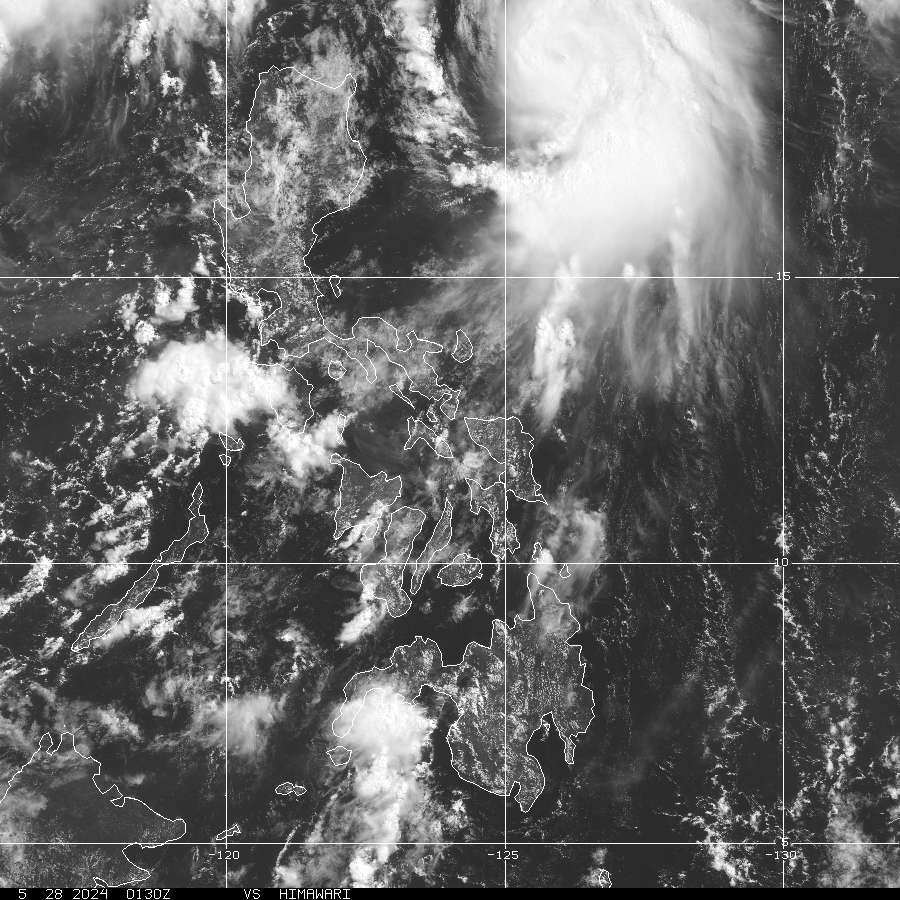
RECENT MTSAT-1R SATELLITE IMAGE:

> Image source: Digital-Typhoon.org (Nat'l. Institute of Informatics) (http://www.digital-typhoon.org )
__________________________________________________________________________________________
NOTES:
> Image source: Digital-Typhoon.
^ - JTWC commentary remarks (for Meteorologists) from their
latest warning.
latest warning.
* - Based on PAGASA's Philippine Storm Warning Signals,
# 4 being the highest. Red letters indicate new areas
being hoisted. For more explanations on these signals,
visit: http://www.typhoon2000.ph/signals.htm
** - Based on the Tropical Cyclone's Wave Height near
its center.
__________________________________________________________________________________________
>> To know the meteorological terminologies and acronyms
used on this update visit the ff:
http://typhoon2000.ph/tcterm.htm
http://www.nhc.noaa.gov/aboutgloss.shtml
http://www.srh.noaa.gov/oun/severewx/glossary.php
http://www.srh.weather.gov/fwd/glossarynation.html
http://www.nhc.noaa.gov/acronyms.shtml
__________________________________________________________________________________________
:: Typhoon2000.com (T2K) Mobile >> Powered by: Synermaxx
Receive the latest storm updates directly to your mobile phones! To know more:
Send T2K HELP to: 2800 (GLOBE & TM) | 216 (SMART & TNT) | 2288 (SUN)
Note: Globe & Smart charges P2.50 per message, while Sun at P2.00.
__________________________________________________________________________________________
For the complete details on TY FITOW (10W)...go visit
our website @:
> http://www.typhoon2000.com
> http://www.maybagyo.com
# 4 being the highest. Red letters indicate new areas
being hoisted. For more explanations on these signals,
visit: http://www.typhoon2
** - Based on the Tropical Cyclone's Wave Height near
its center.
____________
>> To know the meteorological terminologies and acronyms
used on this update visit the ff:
http://typhoon2000.
http://www.nhc.
http://www.srh.
http://www.srh.
http://www.nhc.
____________
:: Typhoon2000.
Receive the latest storm updates directly to your mobile phones! To know more:
Send T2K HELP to: 2800 (GLOBE & TM) | 216 (SMART & TNT) | 2288 (SUN)
Note: Globe & Smart charges P2.50 per message, while Sun at P2.00.
For the complete details on TY FITOW (10W)...go visit
our website @:
> http://www.typhoon2
> http://www.maybagyo
Change settings via the Web (Yahoo! ID required)
Change settings via email: Switch delivery to Daily Digest | Switch format to Traditional
Visit Your Group | Yahoo! Groups Terms of Use | Unsubscribe
.
__,_._,___

No comments:
Post a Comment